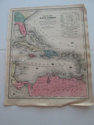
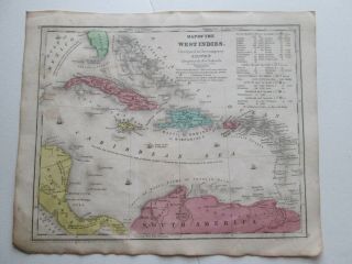
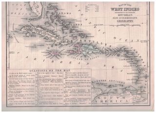
Map Of WEST INDIES C1820 For Walkers Atlas, Engraved, Hand Colour


Item History & Price

Information:
Reference Number: Avaluer:1232645
Original Description:
Antique Map of WEST INDIESEngraved by Thompson for Walkers New Atlas
engraved with later hand colour, good condition, some age tone blank to verso, folds as original issueEngraved area approx: 7" x 8.25" (180mm x 210mm)
MORE GENUINE ANTIQUE MAPS
FROM RARE MAPS AND PRINTS


    Similar items


  • (1) 1848 " Map Of " West Indies ".  1850 Smith

    (1) 1848 " Map Of " West Indies ". 1850 Smith ' S Atlas

  • 1839 Smith

    1839 Smith ' S Atlas " Map Of West Indies "

  • Vintage 1948 Us Navy Map Of West Indies Hispaniola Dominican Republic 18 " X 27 "

    Vintage 1948 Us Navy Map Of West Indies Hispaniola Dominican Republic 18 " X 27 "

  • Map; Mexico & Central America - Map Of West Indies 1887

    Map; Mexico & Central America - Map Of West Indies 1887

  • Mayfairstamps St Vincent 1950 Map Of West Indies Federation First Day Cover Wwb3

    Mayfairstamps St Vincent 1950 Map Of West Indies Federation First Day Cover Wwb3

  • 1700s Map Of South America - Engraved For Walker

    1700s Map Of South America - Engraved For Walker ' S Geography

  • Vintage Lovely Detailed Cartoon Map The Story Map Of West Indies Caribbean 1936

    Vintage Lovely Detailed Cartoon Map The Story Map Of West Indies Caribbean 1936

  • 1879 Map Of West Indies - Details And Colors

    1879 Map Of West Indies - Details And Colors


    • You might also like


Avaluer          About Us          Privacy Policy          Contact Us          UP
© 2022, avaluer.net, Inc. or its affiliates