1850 Antique Map " ISLANDS INDIAN OCEAN " Mauritius Madagascar TALLIS - COLOUR (10

Item History & Price
| Reference Number: Avaluer:15395 |
1850 Antique Map "ISLANDS INDIAN OCEAN" Mauritius Madagascar TALLIS - COLOUR (10 1850 Antique Map "ISLANDS INDIAN OCEAN" Mauritius Madagascar TALLIS - COLOUR (10 1850 Antique Map "ISLANDS INDIAN OCEAN" Mauritius Madagascar TALLIS - COLOUR (10 Click image to enlarge Description "ISLANDS IN THE INDIAN OCEAN" Drawn & engraved by John Rapkin for "The Illustrated Atlas and Modern History of the World" by Martin Montgomery. An attractive and decorative map from the RARE First Editi...on map with vignette engravings of POINT DE GALLE, CEYLON - FALL OF THE RIVER ROCHE ISLE OF BOURBON - PORT LOUIS, MAURITIUS - NORTH BEACH PRINCE OF WALES ISLAND - NATIVE VILLAGE MADAGASCAR. This example with superb full early hand colouring of the decorative border and all of the vignettes Original outline hand colouring. An excellent example of the preferred Montgomery Martin edition. As this example is from the 1st edition, it is not folded and in excellent overall condition. Approx 360mm x 280mm and printed on heavy grade paper. Will look outstanding once mounted and framed. John Tallis is considered to be one of the most renowned cartographers and publisher of the C19th . His maps are considered to be the last of the lavishly decorated and ornamental maps, works of art as much of geography. He was born in Stourbridge in Worcestershire in about 1818 and it is possible he stayed working in the Midlands working as a publisher in Birmingham, until he moved to London in the early 1840’s.John then set up the first of his publishing businesses, in Cripplegate, with Frederick Tallis, who was quite possibly his brother. This business lasted from 1842 to 1849 when it was dissolved. By 1846 the business had moved to Smithfield.From 1851 – 54, John set up another business, operating as John Tallis and Company and it was during this period that he produced the Illustrated World Atlas, produced for the 1851 Great Exhibition The intriguing thing is, that at some point, John Tallis made the acquaintance of an engraver called John Rapkin who was an inspiration to Tallis. His stunning illustrations enabled the maps they produced to be beautiful illumanitive works of art. John Rapkin’s work inspired John Tallis and they used travelogues extensively to guide Joh Rapkin as he produced vignettes and ornamental engravings to embelish the Tallis maps. All our items are original Antiques and as described. We provide a No Quibble Money Back Guarantee Payment We prefer payment via PAYPAL. In some circumstances, we are able to accept a Cheque from UK Buyers, drawn on a UK Bank. Buyers will need to wait for 7 working days for the cheque to clear before any items are sent out. We can also accept Cash Payment in UK Pounds Stirling, Euros or US Dollars, but payment by cash methods are sent at the risk of the buyer. If you want to pay in any way apart from PAYPAL, please contact us PRIOR to making any bid or outright purchase. Shipping We always try to ship items within 3 working days of any order. We are very happy to combine many items for a single postal charge. All our items are sent in either Board Backed envelopes or Art Tubes and are in the case of sending to tropical areas of the world, additionally provded with sealed plastic envelopes. We ship to almost anywhere in the world but there are just a few territories we are unable to ship to. About Us Antique Paper Company are established dealers in Antique Maps, Prints, Stamps, Postal History, Antiquarian Books and in fact all forms of Antique Paper also including Post Cards, Old Posters, Archives, Manuscripts, Ephemera etc. We are keen buyers and are prepared to travel throughout the UK, Europe and most of the world in search of opportunites to buy. Cash funds of up to £250, 000 are available immediately for the right opportunities. We work closely with Libraries & Solicitors/probate situations where they are looking for disposal options and seek better single items to large quantities and also Specialised Collections of almost any genre. Please do not hesitate to contact us with details of any items you might have for sale. Contact Us Pictures sell!Auctiva offers Free Image Hosting and Editing.250+ Listing Templates!Auctiva gets you noticed!The complete eBay Selling Solution. 1850 Antique Map "ISLANDS INDIAN OCEAN" Mauritius Madagascar TALLIS - COLOUR (10 1850 Antique Map "ISLANDS INDIAN OCEAN" Mauritius Madagascar TALLIS - COLOUR (10
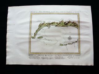
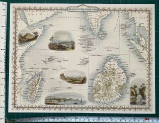
1850 Antique Map "ISLANDS INDIAN OCEAN" Mauritius Madagascar TALLIS - COLOUR (10 Click image to enlarge Description "ISLANDS IN THE INDIAN OCEAN"
Drawn & engraved by John Rapkin for "The Illustrated Atlas and Modern History of the World" by Martin Montgomery.An attractive and decorative map from the RARE First Edition map with vignette engravings of POINT DE GALLE, CEYLON - FALL OF THE RIVER ROCHE ISLE OF BOURBON - PORT LOUIS, MAURITIUS - NORTH BEACH PRINCE OF WALES ISLAND - NATIVE VILLAGE MADAGASCAR.
This example with superb full early hand colouring of the decorative border and all of the vignettes
Original outline hand colouring. An excellent example of the preferred Montgomery Martin edition.
As this example is from the 1st edition, it is not folded and in excellent overall condition. Approx 360mm x 280mm and printed on heavy grade paper. Will look outstanding once mounted and framed. John Tallis is considered to be one of the most renowned cartographers and publisher of the C19th .His maps are considered to be the last of the lavishly decorated and ornamental maps, works of art as much of geography. He was born in Stourbridge in Worcestershire in about 1818 and it is possible he stayed working in the Midlands working as a publisher in Birmingham, until he moved to London in the early 1840’s.John then set up the first of his publishing businesses, in Cripplegate, with Frederick Tallis, who was quite possibly his brother. This business lasted from 1842 to 1849 when it was dissolved. By 1846 the business had moved to Smithfield.From 1851 – 54, John set up another business, operating as John Tallis and Company and it was during this period that he produced the Illustrated World Atlas, produced for the 1851 Great ExhibitionThe intriguing thing is, that at some point, John Tallis made the acquaintance of an engraver called John Rapkin who was an inspiration to Tallis. His stunning illustrations enabled the maps they produced to be beautiful illumanitive works of art.John Rapkin’s work inspired John Tallis and they uséd travelogues extensively to guide Joh Rapkin as he produced vignettes and ornamental engravings to embelish the Tallis maps.All our items are original Antiques and as described.We provide a No Quibble Money Back Guarantee Payment We prefer payment via PAYPAL. In some circumstances, we are able to accept a Cheque from UK Buyers, drawn on a UK Bank. Buyers will need to wait for 7 working days for the cheque to clear before any items are sent out. We can also accept Cash Payment in UK Pounds Stirling, Euros or US Dollars, but payment by cash methods are sent at the risk of the buyer. If you want to pay in any way apart from PAYPAL, please contact us PRIOR to making any bid or outright purchase. Shipping We always try to ship items within 3 working days of any order. We are very happy to combine many items for a single postal charge. All our items are sent in either Board Backed envelopes or Art Tubes and are in the case of sending to tropical areas of the world, additionally provded with sealed plastic envelopes.
We ship to almost anywhere in the world but there are just a few territories we are unable to ship to.
About Us Antique Paper Company are established dealers in Antique Maps, Prints, Stamps, Postal History, Antiquarian Books and in fact all forms of Antique Paper also including Post Cards, Old Posters, Archives, Manuscripts, Ephemera etc.
We are keen buyers and are prepared to travel throughout the UK, Europe and most of the world in search of opportunites to buy. Cash funds of up to £250, 000 are available immediately for the right opportunities. We work closely with Libraries & Solicitors/probate situations where they are looking for disposal options and seek better single items to large quantities and also Specialised Collections of almost any genre.
Please do not hesitate to contact us with details of any items you might have for sale. Contact Us
Pictures sell!
Auctiva offers Free Image Hosting and Editing.250+ Listing Templates!
Auctiva gets you noticed!
The complete eBay Selling Solution.
Track Page Views With
Auctiva's FREE Counter ×
Buy now and save! Tell a friend Visit store Watch now Postage info Click the Postage tab above the listing description for more info FREE Postage See more... Royal Mail 1st Class Signed For - £0.00 Royal Mail Special Delivery (TM) 1:00 pm - £7.50 Royal Mail International Tracked - £10.00 Click the Postage tab above the listing description for more info! Additional delivery notes PICK UP OPTION Sorry, our items are NOT available for pick-up. PAYING VIA PAYPAL
We accept PayPal on our all our items so you can shop with confidence. Simple choose the PayPal option when proceeding through the checkout. Additional Information No additional information at this time Ask seller a question You might also like 1855 Antique Print - RUSSIA Crimea Sebastopol Trenches Crowe Soldiers (322) 1855 Antique Print LONDON Westminster Royal Commissioners Patriotic Fund (120) 1855 FINE ART Antique Print - Runaway Knock George Cruikshank British Dogs (92) 1855 Antique Print - FRANCE Paris New Years Gifts Family Table Bonnet Chair(244) Contact To contact our Customer Service Team, simply click the button here and our Customer Service team will be happy to assist. Ask seller a question © antiquepapercompany Postage Shipping is FREE for this item Payment Accepted Payment Methods PayPal Returns Returns are accepted Items must be returned within 30 days of the auction ending Buyer will pay for return shipping. eBay integration by