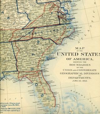
CIVIL WAR ATLAS MAP: UNITED STATES, CONFEDERATE STATES June 30, 1861


Item History & Price
| Reference Number: Avaluer:16354588 |
One complete, uncut, ORIGINAL Civil War Atlas map sheet...18" by 29"...from the 1890's U.S. Government limited issue ATLAS TO ACCOMPANY THE OFFICIAL RECORDS OF THE UNION AND CONFEDERATE ARMIES. Plate number 163, in immaculate original condition, is a large map showing The United States and Confederate States as they were June 30, 1861!The full US-CS maps are by far the most prized from within The Official Atlas, and this early War map is immaculate, very clearly defined and a true trea...sure.Union and Confederate Divisions and Departments are shown; states and territories, including Indian Territory; exploration routes, early roads, US mail routes including the Pony Express Route and so much more.
THE OFFICIAL ATLAS, as it is called, represents the culmination of decades of research after The War, and was contributed to by the military leaders of The War, civil engineers and cartographers, and was intended to be THE companion to The OFFICIAL RECORDS OF THE CIVIL WAR. The complete ATLASES were not available to the public, rather they were sent in a series of five sheets at a time, 178 sheets in total, to the three branches of government and to federal and state agencies and libraries. When THE OFFICIAL ATLAS was printed, over 120 years ago, each large map sheet was folded once, neatly, left side over right and this plate has been preserved well, and has retained its original sharp, bold, crisp character. The map is immaculate. The plate has a complete one inch border all the way around. Please note, and this is important. This is an ENTIRE Atlas map sheet. It is NOT part of a plate nor is it a cut piece, but it is a whole plate, as it was lithographed over a century ago. I will never cut pieces from these rare antique map sheets and sell the smaller slips of paper separately. Besides the obvious beauty and historic charm of these pieces, a very large part of their long term investment value is in their entirety. I will cover your fully insured Priority mailing. Map will be rolled carefully, packed extremely well into a rigid tube, and sent to you in a Priority mailer. This is one exceptional piece!
00046