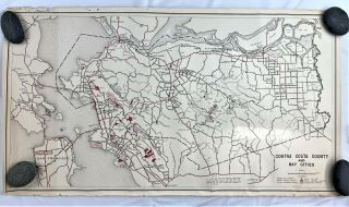
San Francisco Bay Area, CALIFORNIA - Topographical View - MAP


Item History & Price
| Reference Number: Avaluer:3490421 | City/Region: San Francisco Bay Area |
| Era: Linen (c. 1930-1945) | Type: Printed (Lithograph) |
| Features: MAP | Topographical Map: San Francisco Bay Area, CA |
San Francisco Bay Area, CALIFORNIA - Topographical View - MAP: This Linen Era (1930-45) postcard offers a topographical view of the San Francisco Bay Area, commonly referred to as the Bay Area. It is a populated region that surrounds the San Francisco and San Pablo estuaries in Northern California. The region encompasses the major cities and metropolitan areas of San Francisco, Oakland, and San Jose, along with smaller urban and rural areas. The Bay Area's nine counties are Alameda, Co...ntra Costa, Marin, Napa, San Francisco, San Mateo, Santa Clara, Solano, and Sonoma. Home to approximately 7.44 million people, the nine-county Bay Area contains many cities, towns, airports, and associated regional, state, and national parks, connected by a network of roads, highways, railroads, bridges, tunnels and commuter rail. The combined statistical area of the region is the second-largest in California (after the Greater Los Angeles area), the fifth-largest in the United States, and the 43rd-largest urban area in the world. The owner indicated the directions of the compass shown. As on looks from West (the Pacific Ocean) east. The card is in good condition, but shows some edge wear. The author notes in his/her comments "Good 'layout' of the area considering it is an air view. But shows the position of all 'neighboring' cities, although Sacramento (north) is almost 100 miles distant. The Bay, from Vallejo (north) to near San Jose (south) is about 60 miles long, and at San Francisco is 4 miles in width to Oakland's shore line. Note Alameda (center, island) and Berkley (left from Oakland) and Mt. Diablo in east distance, with the "Peninsula" cities to the south from San Francisco. The San Joaquin and Sacramento rivers flow in just above Suisun Bay (left). Fresno (far south) is five hours via train. Regards and 'superb' mint and used 'finds'. Mappin." The card is in good condition, but shows some edge wear. Scenic View Card Co., San Francisco, Cal. No. 43701. Nature Tone Views.