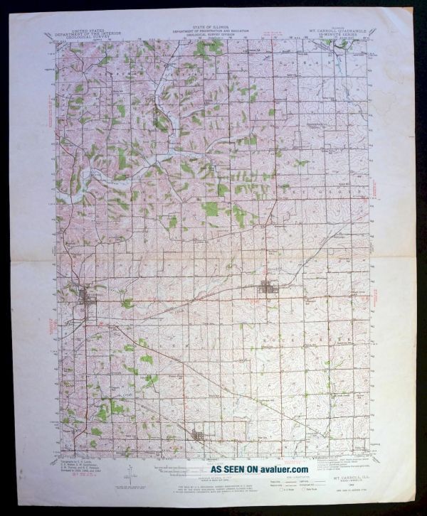
1942 Mount Carroll Illinois Lanark 15 - Minute USGS Topographic Topo Map
Item History & Price
1942 MOUNT CARROLL ILLINOIS USGS TOPO MAP Vintage Cartographics Illinois Maps ∙ Antique Prints ∙ Bargain Bin ∙ Browse Nearby Sheets 1942
Mount Carroll
Illinois
USGS TOPOGRAPHIC MAP
1972 print in good condition
For sale is the 1942 edition of the Mount Carroll 15-minute map. This map would be ideal for framing or display, historical refe...rence or research, genealogy studies, adding to your collection, treasure hunting, a nice conversation piece, a gift for a history or map enthusiast, or for anyone interested in this area. Maps of this vintage are printed on durable stock and are well-suited for outdoor activities and recreation of all kinds. This sheet includes the only survey produced by the United States Geological Survey for the Mount Carroll 15-minute quadrangle. The map sheet is an original 1972 USGS print in good condition. The Mount Carroll 15-minute map shows all roads, paths, towns, railroads, rivers, creeks, elevation contour lines, public land survey lines, county, state, and other administrative boundaries as they existed at the time of the survey in 1939 through 1942. A reddish tint may be used on this sheet to indicate urban areas where only landmark buildings will be shown. Outside of those areas, all known structures (houses, businesses churches, schools, barns, cabins, etc) are shown. Maps from the 15-minute series for the continental United States are no longer produced or printed by the USGS and original prints are becoming increasingly difficult to find. They are a valuable historical record for an area, as they contain many placenames and features that have been dropped from more recent maps. MAP DETAILS Title Mount Carroll State Illinois Series 15-minute Surveyed 1939 through 1942 Aerial and Field Survey Edition 1942 Printed 1972 Woodland Tint Yes Scale 1:62500 Contour Interval 20 Foot Sheet Dimensions 16 1/2 x 20 inches (approximate) Map Dimensions 13 x 17 1/2 inches Coverage Area 13 x 17 miles SHEET CONDITION Overall Condition GOOD Sheet Notes moderately handled, midsheet horizontal foldline Map Area no markings, no blemishes, slight age discoloration along centerline fold, minor pencil notations found within map area Collar Area very minor markings, minor blemishes, collars show signs of considerable handling, upper right collar area has light moisture blemishes MAP COVERAGE Quadrangle extent overlaid on current basemap. Browse Nearby
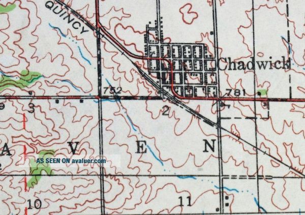
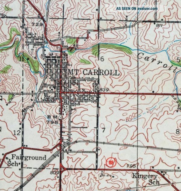
Sheets PLACENAMES Depending on map series and survey date, all of the features listed below may not be shown on this map. This list contains features that currently exist or historically existed within the area covered by this map. The list can be used as a reference to determine if this map covers your area of interest. Placenames are listed alphabetically next to each feature type. Cities and Towns (current) Chadwick, Lanark, and Mount Carroll Counties Covered Carroll, Jo Daviess, and Stephenson Rivers and Streams Boone Branch, Carroll Creek, Davis Creek, East Fork Creek, East Johnson Creek, East Plum River, Johnson Creek, Lost Creek, Muddy Plum River, Otter Creek, Rock Creek, Sand Creek, Spring Branch, Straddle Creek, and Yellow Creek Water Bodies Lake Carroll Populated Places: Ashdale Junction, Chadwick, Georgetown, Kittredge, Lanark, Loran, Mount Carroll, and Zier Cors. Post Offices: Lanark Post Office and Mount Carroll Post Office. Locations: Carroll County Farm and Watermans Mills. Administrative Boundaries: Township of Berreman, Township of Cherry Grove-Shannon, Township of Freedom, Township of Jefferson, Township of Loran, Township of Rock Creek-Lima, and Township of Salem. Valleys and Canyons: Dyslin Valley and Skunk Hollow. Parks: Mount Carroll Historic District. Drainages: Boone Branch, East Fork Creek, Lost Creek, and Spring Branch. Churches: Black Oak Church, Sabin Church, Trinity Church, Union Church, and Woodland Church. Dams: Lake Carroll Dam and Timber Lake Dam. Reservoirs and Tanks: Lake Carroll and Timber Lake. Airports: Block Airport, Kenneth Moll Airport, Plum Creek Farm Airport, Swan Valley Farm Airport, Tautz Brothers Airport, and Williard Nycum RLA Airport. Schools: Arnold Grove School, Arnold School, Center School, Central School, Chadwick Junior High School, Cloverdale School, Daggett School, Dimon School, Dyslin Valley School, Eastland High School, Eastwood School, Emerson School, Fairground School, Fairview School, Ferrin School, Freedom School, Grissinger School, Hayes School, Hazel Green School, Hershey School, Hillside School, Honberger School, Kingery School, Lamb School, Libertyville School, Maple Grove School, Mission Ridge School, Mount Carroll High School, North Otter Creek School, Oakville School, Pleasant Hill School, Ray School, Reede School, Renner School, Rogers School, Rowland School, Sage School, Shriner School, Slick School, Spring Valley School, Star School, Straw School, Union School, Valley View School, and Vinegar Hill School. SHIPPING AND RETURNS This map sheet will be carefully rolled in a sturdy tube and shipped via the US Postal Service. Shipping and handling costs are included in the purchase price.
If you find that the sheet you receive is not as described in the listing, you may ship it back to us for a refund of the purchase price. 15~4628 15~4629 15~4630 15~4829 15~4830 15~4831 15~4832 15~4833 15~4834 15~4835 15~5035 15~5036 15~5037 15~5038 15~5039 15~5040 15~5041 15~5243 15~5244 15~5245 15~5246 15~5247 15~5248 15~5249 15~5459 15~5460 15~5461 15~5462 15~5463 30~1203 30~1306 30~1413 30~1414 75~17717 75~17718 75~17719 75~17871 75~18100 75~18101 75~18102 75~18103 75~18104 75~18266 75~18510 75~18511 75~18512 75~18513 75~18514 75~18515 75~18516 75~18517 75~18902 75~18903 75~18904 75~18905 75~18906 75~18907 75~19076 75~19077 75~19291 75~19292 75~19293 75~19294 75~19295 75~19474 75~19721 75~19722 75~19723 75~19724
Mount Carroll
Illinois
USGS TOPOGRAPHIC MAP
1972 print in good condition
For sale is the 1942 edition of the Mount Carroll 15-minute map. This map would be ideal for framing or display, historical refe...rence or research, genealogy studies, adding to your collection, treasure hunting, a nice conversation piece, a gift for a history or map enthusiast, or for anyone interested in this area. Maps of this vintage are printed on durable stock and are well-suited for outdoor activities and recreation of all kinds. This sheet includes the only survey produced by the United States Geological Survey for the Mount Carroll 15-minute quadrangle. The map sheet is an original 1972 USGS print in good condition. The Mount Carroll 15-minute map shows all roads, paths, towns, railroads, rivers, creeks, elevation contour lines, public land survey lines, county, state, and other administrative boundaries as they existed at the time of the survey in 1939 through 1942. A reddish tint may be used on this sheet to indicate urban areas where only landmark buildings will be shown. Outside of those areas, all known structures (houses, businesses churches, schools, barns, cabins, etc) are shown. Maps from the 15-minute series for the continental United States are no longer produced or printed by the USGS and original prints are becoming increasingly difficult to find. They are a valuable historical record for an area, as they contain many placenames and features that have been dropped from more recent maps. MAP DETAILS Title Mount Carroll State Illinois Series 15-minute Surveyed 1939 through 1942 Aerial and Field Survey Edition 1942 Printed 1972 Woodland Tint Yes Scale 1:62500 Contour Interval 20 Foot Sheet Dimensions 16 1/2 x 20 inches (approximate) Map Dimensions 13 x 17 1/2 inches Coverage Area 13 x 17 miles SHEET CONDITION Overall Condition GOOD Sheet Notes moderately handled, midsheet horizontal foldline Map Area no markings, no blemishes, slight age discoloration along centerline fold, minor pencil notations found within map area Collar Area very minor markings, minor blemishes, collars show signs of considerable handling, upper right collar area has light moisture blemishes MAP COVERAGE Quadrangle extent overlaid on current basemap. Browse Nearby
Sheets PLACENAMES Depending on map series and survey date, all of the features listed below may not be shown on this map. This list contains features that currently exist or historically existed within the area covered by this map. The list can be used as a reference to determine if this map covers your area of interest. Placenames are listed alphabetically next to each feature type. Cities and Towns (current) Chadwick, Lanark, and Mount Carroll Counties Covered Carroll, Jo Daviess, and Stephenson Rivers and Streams Boone Branch, Carroll Creek, Davis Creek, East Fork Creek, East Johnson Creek, East Plum River, Johnson Creek, Lost Creek, Muddy Plum River, Otter Creek, Rock Creek, Sand Creek, Spring Branch, Straddle Creek, and Yellow Creek Water Bodies Lake Carroll Populated Places: Ashdale Junction, Chadwick, Georgetown, Kittredge, Lanark, Loran, Mount Carroll, and Zier Cors. Post Offices: Lanark Post Office and Mount Carroll Post Office. Locations: Carroll County Farm and Watermans Mills. Administrative Boundaries: Township of Berreman, Township of Cherry Grove-Shannon, Township of Freedom, Township of Jefferson, Township of Loran, Township of Rock Creek-Lima, and Township of Salem. Valleys and Canyons: Dyslin Valley and Skunk Hollow. Parks: Mount Carroll Historic District. Drainages: Boone Branch, East Fork Creek, Lost Creek, and Spring Branch. Churches: Black Oak Church, Sabin Church, Trinity Church, Union Church, and Woodland Church. Dams: Lake Carroll Dam and Timber Lake Dam. Reservoirs and Tanks: Lake Carroll and Timber Lake. Airports: Block Airport, Kenneth Moll Airport, Plum Creek Farm Airport, Swan Valley Farm Airport, Tautz Brothers Airport, and Williard Nycum RLA Airport. Schools: Arnold Grove School, Arnold School, Center School, Central School, Chadwick Junior High School, Cloverdale School, Daggett School, Dimon School, Dyslin Valley School, Eastland High School, Eastwood School, Emerson School, Fairground School, Fairview School, Ferrin School, Freedom School, Grissinger School, Hayes School, Hazel Green School, Hershey School, Hillside School, Honberger School, Kingery School, Lamb School, Libertyville School, Maple Grove School, Mission Ridge School, Mount Carroll High School, North Otter Creek School, Oakville School, Pleasant Hill School, Ray School, Reede School, Renner School, Rogers School, Rowland School, Sage School, Shriner School, Slick School, Spring Valley School, Star School, Straw School, Union School, Valley View School, and Vinegar Hill School. SHIPPING AND RETURNS This map sheet will be carefully rolled in a sturdy tube and shipped via the US Postal Service. Shipping and handling costs are included in the purchase price.
If you find that the sheet you receive is not as described in the listing, you may ship it back to us for a refund of the purchase price. 15~4628 15~4629 15~4630 15~4829 15~4830 15~4831 15~4832 15~4833 15~4834 15~4835 15~5035 15~5036 15~5037 15~5038 15~5039 15~5040 15~5041 15~5243 15~5244 15~5245 15~5246 15~5247 15~5248 15~5249 15~5459 15~5460 15~5461 15~5462 15~5463 30~1203 30~1306 30~1413 30~1414 75~17717 75~17718 75~17719 75~17871 75~18100 75~18101 75~18102 75~18103 75~18104 75~18266 75~18510 75~18511 75~18512 75~18513 75~18514 75~18515 75~18516 75~18517 75~18902 75~18903 75~18904 75~18905 75~18906 75~18907 75~19076 75~19077 75~19291 75~19292 75~19293 75~19294 75~19295 75~19474 75~19721 75~19722 75~19723 75~19724