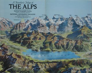
Berann Panorama Map ALPS France Austria Germany Zermatt Matterhorn Mont Blanc


Item History & Price
| Reference Number: Avaluer:4805839 | Year: 1985 |
| Makes: National Geographic | Country/Region of Manufacture: United States |
| Type: Topographical Map | Region or Country: Europe |
| UPC: Does not apply |
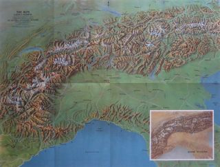
Beautifulfold-out 2-sided color lithographed shaded relief map of the Alps. This handsome map opens to agenerous22½" x 36" and is loaded with historical and topographicalinformation on one of the great mountain range systems of Europe, stretching from Austria and Slovenia in the east through Italy, Switzerland, Liechtenstein and Germany to France in the west.
The map offers a panoramic view of the Bernese Alps, oneof Europe'sleading resort areas, painted by Austrian landscape a...rtist HeinrichBerann. Berann's distinctive signature is at the lower left.
Beneath this charming Swiss panorama is a fascinatinghistoryof the rugged mountain range which separates northern Europe from theMediterranean, with a cluster of locator maps.
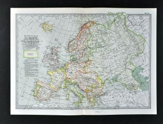
On the reverse side there is a topographic map, drawn ona scale of1:1, 057, 000, or 16.7 miles to one inch, covering the area fromMarseille to the eastern Adriatic, north to Ulm, Augsburg, and Vienna.
Among the named places and features depicted areGrenoble, Lake Geneva, Liechtenstein, Innsbruck, Salzburg, Mont Blanc, the Matterhorn, St.Moritz, Ljubljana, Garmisch-Partenkirken, Bergamo, Verona, Trieste, andmore.
It also locates numerous passes through the mountains andthesources of various rivers, including the Rhine, the Rhone, and the Po.
This map was drawn by Hungarian cartographer Tibor G.Tóth, who hadalso done maps for Freytag-Berndt und Artaria and the AmericanGeographical Society. Tóth's signature appears in the lowerleft corner.
Condition: This handsome 2-sided map is in excellentcondition, bright and clean, with nomarks, rips, or tears. It folds to approximately 9" x 5¾". Please see thescansand feel free to ask any questions.
The map was published by the National Geographic Societyas a supplement tothe April 1985 National Geographic Magazine.
Please note: There are three differenteditions of this map: one with a small signature by Tóth in the lowercorner, one with a large signature, and one with no signature. The mapoffered in this listingis the one with the small signature; we may also have the othereditions available, if you may be interested.
Buy with confidence! We are always happy to combineshipping on the purchase of multiple items — just make sure to pay foreverythingat one time, not individually.
Powered by SixBit's eCommerce Solution
00131
The map offers a panoramic view of the Bernese Alps, oneof Europe'sleading resort areas, painted by Austrian landscape a...rtist HeinrichBerann. Berann's distinctive signature is at the lower left.
Beneath this charming Swiss panorama is a fascinatinghistoryof the rugged mountain range which separates northern Europe from theMediterranean, with a cluster of locator maps.
On the reverse side there is a topographic map, drawn ona scale of1:1, 057, 000, or 16.7 miles to one inch, covering the area fromMarseille to the eastern Adriatic, north to Ulm, Augsburg, and Vienna.
Among the named places and features depicted areGrenoble, Lake Geneva, Liechtenstein, Innsbruck, Salzburg, Mont Blanc, the Matterhorn, St.Moritz, Ljubljana, Garmisch-Partenkirken, Bergamo, Verona, Trieste, andmore.
It also locates numerous passes through the mountains andthesources of various rivers, including the Rhine, the Rhone, and the Po.
This map was drawn by Hungarian cartographer Tibor G.Tóth, who hadalso done maps for Freytag-Berndt und Artaria and the AmericanGeographical Society. Tóth's signature appears in the lowerleft corner.
Condition: This handsome 2-sided map is in excellentcondition, bright and clean, with nomarks, rips, or tears. It folds to approximately 9" x 5¾". Please see thescansand feel free to ask any questions.
The map was published by the National Geographic Societyas a supplement tothe April 1985 National Geographic Magazine.
Please note: There are three differenteditions of this map: one with a small signature by Tóth in the lowercorner, one with a large signature, and one with no signature. The mapoffered in this listingis the one with the small signature; we may also have the othereditions available, if you may be interested.
Buy with confidence! We are always happy to combineshipping on the purchase of multiple items — just make sure to pay foreverythingat one time, not individually.
Powered by SixBit's eCommerce Solution
00131