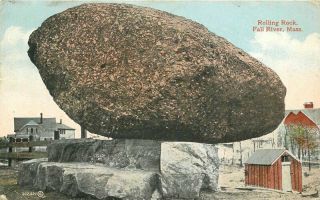
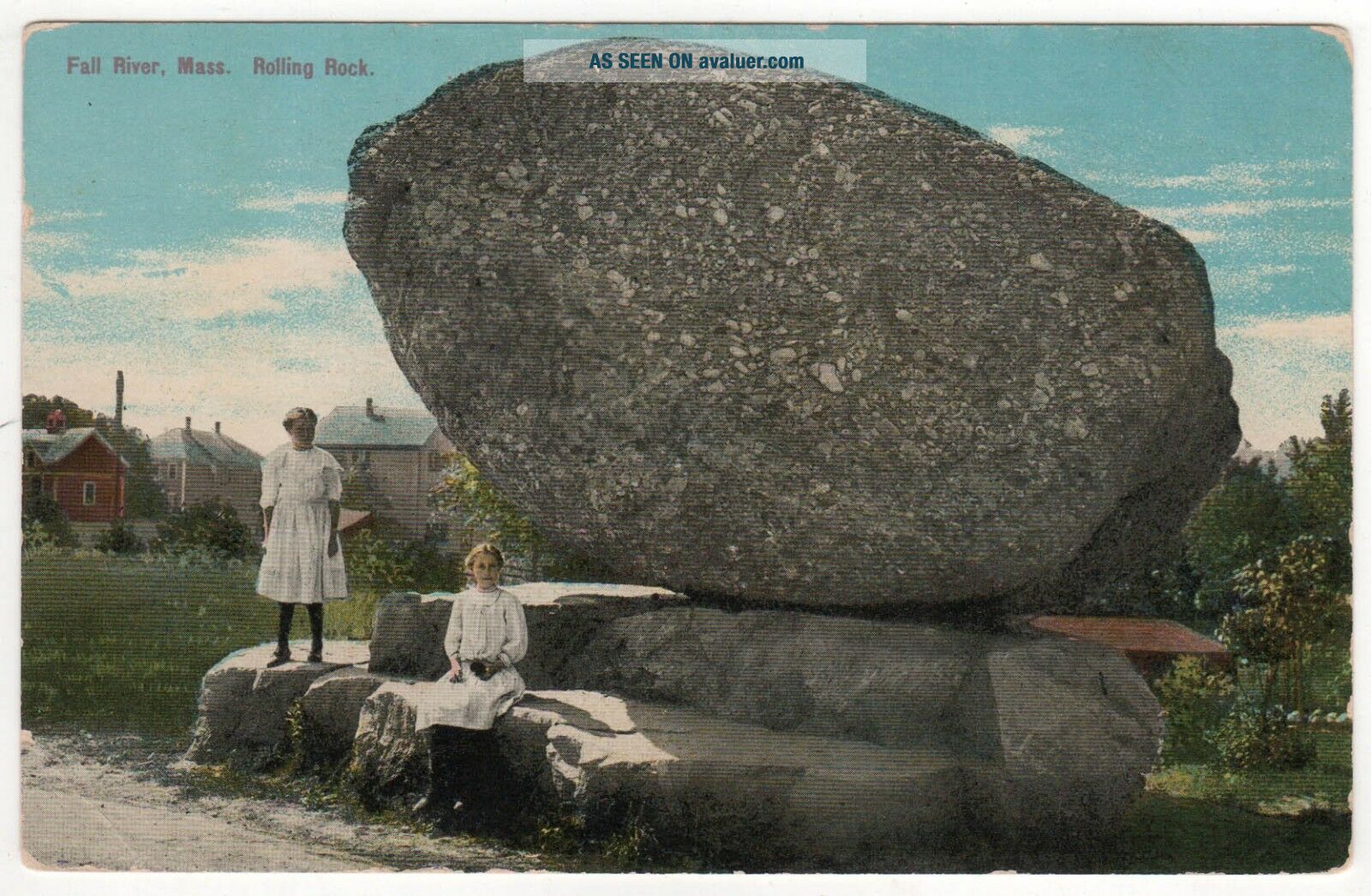
FALL RIVER MASSACHUSETTS PC Postcard ROLLING ROCK Balanced HUGH LEIGHTON Mass MA
Item History & Price
| Reference Number: Avaluer:48534814 | Type: Printed (Lithograph) |
| City/Region: Fall River |
FALL RIVER PCFREE SHIPPING with delivery confirmation on all domestic purchases!"Fall River, Mass, Rolling Rock"Posted.We ship worldwide! Please see all pictures and visit our eBay store and other eBay auctions!Fall River is a city in Bristol County, Massachusetts, United States. Fall River's population was 87, 103 at the 2010 census, [6] making it the tenth-largest city in the state.Located along the eastern shore of Mount Hope Bay at the mouth of the Taunton River, the city beca...me famous during the 19th century as the leading textile manufacturing center in the United States. While the textile industry has long since moved on, its impact on the city's culture and landscape remains to this day. Fall River's official motto is "We'll Try, " dating back to the aftermath of the Great Fire of 1843. It is also nicknamed "the Scholarship City" because Dr. Irving Fradkin founded Dollars for Scholars here in 1958. In 2017, Mayor Correia introduced the "Make It Here" slogan as part of a citywide rebranding effort.[3]Fall River is known for the Lizzie Borden case, Portuguese culture, its numerous 19th-century textile mills and Battleship Cove, the world's largest collection of World War II naval vessels and the home of the USS Massachusetts (BB-59). Fall River is also the only city in the United States to have its city hall located over an interstate highway.Main article: History of Fall River, Massachusetts
Colonial period to 1800s
At the time of the establishment of the Plymouth Colony in 1620, the area that would one day become Troy City was inhabited by the Pokanoket Wampanoag tribe, headquartered at Mount Hope in what is now Bristol, Rhode Island. The "falling" river that the name Fall River refers to is the Quequechan River (pronounced "quick-a-shan" by locals) which flows through the city, dropping steeply into the bay. Quequechan is a Wampanoag word believed to mean "Falling River" or "Leaping/Falling Waters." During the 1960s, Interstate 195 was constructed through the city along the length of the Quequechan River. The portion west of Plymouth Avenue was routed underground through a series of box culverts, while much of the eastern section "mill pond" was filled in for the highway embankment.In 1653, Freetown was settled at Assonet Bay by members of the Plymouth Colony, as part of Freeman's Purchase, which included the northern part of what is now Fall River. In 1683, Freetown was incorporated as a town within the colony. The southern part of what is now Fall River was incorporated as the town of Tiverton as part of the Massachusetts Bay Colony in 1694, a few years after the merger with Plymouth Colony. In 1746, in the settlement of a colonial boundary dispute between Rhode Island and Massachusetts, Tiverton was annexed to Rhode Island, along with Little Compton and what is now Newport County, Rhode Island. The boundary was then placed approximately at what is now Columbia Street.In 1703, Benjamin Church, a hero of King Philip's War established a saw mill, grist mill, and a fulling mill on the Quequechan River. In 1714, Church sold his land, along with the water rights to Richard Borden of Tiverton and his brother Joseph. This transaction would prove to be extremely valuable 100 years later, helping to establish the Borden family as the leaders in the development of Fall River's textile industry.During the 18th century the area consisted mostly of small farms and relatively few inhabitants. In 1778, the Battle of Freetown, was fought here during the American Revolutionary War (1775-1783) after British raids badly damaged Bristol and Warren. The militia of Fall River, at that time known as Freetown, put up a stronger defense against a British force.In 1803, Fall River was separated from Freetown and officially incorporated as its own town. A year later, Fall River changed its name to "Troy." The name "Troy" was used for 30 years and was officially changed back to Fall River on February 12, 1834. During this period, Fall River was governed by a three-member Board of Selectmen, until it became a City in 1854.In July 1843, the first great fire in Fall River's history destroyed much of the town center, including the Atheneum, which housed the Skeleton in Armor which had been discovered in a sand bank in 1832 near what is now the corner of Hartwell and Fifth Street.During this time, the southern part of what is now Fall River (south of Columbia Street) would remain part of Tiverton, Rhode Island. In 1856, the town of Tiverton, Rhode Island voted to split off its industrial northern section as Fall River, Rhode Island. In 1861, after decades of dispute, the United States Supreme Court moved the state boundary to what is now State Avenue, thereby creating a City of Fall River entirely within Massachusetts. (Also as part of this decision, Pawtucket, Massachusetts and Pawtucket Rhode Island were cities next to each other only separated by the river. During this time Fall River, Seekonk were part of Rhode Island. Central Falls, Rumford were towns in Massachusetts. for a fair land exchange these towns changed states.[7])Industrial development and prosperityGroup of workers in the Sagamore Mfg. Co., August 1911. Photographed by Lewis Hine.
See also: List of mills in Fall River, Massachusetts
The 19th century
The early establishment of the textile industry in Fall River grew out of the developments made in nearby Rhode Island beginning with Samuel Slater at Pawtucket in 1793. In 1811, Col. Joseph Durfee, the Revolutionary War veteran and hero of the Battle of Freetown in 1778 built the Globe Manufactory (a spinning mill) at the outlet of Cook Pond on Dwelly St. near what is now Globe Four Corners in the city's South End. (It was part of Tiverton, Rhode Island at the time.) While Durfee's mill was never very successful, it marked the beginning of the city's rise in the textile business.The real development of Fall River's industry, however, would occur along the falling river from which it was named, about a mile north of Durfee's first mill. The Quequechan River, with its eight falls, combined to make Fall River the best tidewater privilege in southern New England. It was perfect for industrialization—big enough for profit and expansion, yet small enough to be developed by local capital without interference from Boston.[8]The Fall River Manufactory was established by David Anthony and others in 1813. That same year, the Troy Cotton & Woolen Manufactory was also founded, by a group of investors led by Oliver Chace, from Swansea, who had worked as a carpenter for Samuel Slater in his early years. The Troy Mill opened in 1814, at the upper end of the falls.In 1821, Colonel Richard Borden established the Fall River Iron Works, along with Maj. Bradford Durfee at the lower part of the Quequechan River. Durfee was a shipwright, and Borden was the owner of a grist mill. After an uncertain start, in which some early investors pulled out, the Fall River Iron Works was incorporated in 1825. The Iron Works began producing nails, bar stock, and other items such as bands for casks in the nearby New Bedford whaling industry. They soon gained a reputation for producing nails of high quality, and business flourished. In 1827, Col. Borden began regular steamship service to Providence, Rhode Island.[9]The American Print Works was established in 1835 by Holder Borden, uncle of Colonel Richard. With the leadership of the Borden family, the American Print Works (later known as the American Printing Company) became the largest and most important textile company in the city, employing thousands at its peak in the early 20th century. Richard Borden also constructed the Metacomet Mill in 1847, which today is the oldest remaining textile (cloth-producing) mill in the city, located on Anawan Street.By 1845, the Quequechan's power had been all but maximized. The Massasoit Steam Mill was established in 1846, above the dam near the end of Pleasant Street. However, it would be another decade or so when improvements in the steam engine by George Corliss would enable the construction of the first large steam-powered mill in the city, the Union Mills in 1859.The advantage of being able to import bales of cotton and coal to fuel the steam engines to Fall River's deep water harbor, and ship out the finished goods also by water, made Fall River the choice of a series of cotton mill magnates. The first railroad line serving Fall River, The Fall River Branch Railroad, was incorporated in 1844 and opened in 1845. Two years later, in 1847, the first regular steamboat service to New York City began. The Fall River Line as it came to be known operated until 1937, and for many years, was the preferred way to travel between Boston and Manhattan. The Old Colony Railroad and Fall River Railroad merged in 1854, forming the Old Colony and Fall River Railroad.In 1854, Fall River was officially incorporated as a city, and had a population of about 12, 000.[10] Its first mayor was James Buffington.Fall River profited well from the American Civil War and was in a fine position to take advantage of the prosperity that followed. By 1868, it had surpassed Lowell as the leading textile city in America with over 500, 000 spindles.The boom in the 1870sBorder City Mill
Then, during 1871 and 1872, a "most dramatic expansion" of the city occurred: 15 new corporations were founded, building 22 new mills throughout the city, while some of the older mills expanded. The city's population increased by 20, 000 people during these two years, while overall mill capacity doubled to more than 1, 000, 000 spindles.[citation needed]By 1876, the city had 1/6 of all New England cotton capacity and one-half of all print cloth production. The "Spindle City" as it became known, was second in the world to only Manchester, England.To house the thousands of new workers, mostly Irish and French Canadian immigrants during these years, over 12, 000 units of company housing were built. Unlike the well-spaced boardinghouses of early Lowell or the tidy cottages of Rhode Island, worker housing in Fall River consisted of thousands of wood-framed multi-family tenements, usually three-floor "triple-deckers" with up to six apartments. Many more privately owned tenements supplemented the company housing.[11]During the 19th century, Fall River became famous for the granite rock on which much of the city is built. Several granite quarries operated during this time, the largest of which was the Beattie Granite Quarry, near what is now North Quarry Street, near the corner of Locust.[12] Many of the mills in the city were built from this native stone, and it was highly regarded as a building material for many public buildings and private homes alike. The Chateau-sur-Mer mansion in Newport, Rhode Island is perhaps the best example of Fall River granite being used for private home construction.While most of the mills "above the hill" were constructed from native Fall River granite, nearly all of their counterparts along the Taunton River and Mount Hope Bay were made of red brick. This was due to the high costs and impracticality associated with transporting the rock through the city and down the hill, where there were no rail lines because of the steep grades. (One notable exception is the Sagamore Mills on North Main Street, which were constructed from similar rock quarried in Freetown and brought to the site by rail.)The 20th century
Fall River rode the wave of economic prosperity well into the early 20th century. During this time, the city boasted several fancy hotels, theaters, and a bustling downtown. As the city continually expanded during the late 19th century, its leaders built several fine parks, schools, streetcar lines, a public water supply, and sewerage system to meet the needs of its growing population.From 1896 to 1912, Fall River was the headquarters of the E. P. Charlton & Company chain of five and ten cent stores. Founded at Fall River in 1890 by Seymour H. Knox and Earle Perry Charlton as the Knox & Charlton Five and Ten Cent Store, by the time of its merger with several other retailers to form the F. W. Woolworth Company in 1912, Charlton operated fifty-eight stores in the United States and Canada.In 1920 the population of Fall River peaked at 120, 485.[13]
North Main Street, c. 1910 First Cotton Mill, built in 1811 Printing Works, c. 1920 The Charlton Block, 1908
Davol Mills
The cotton mills of Fall River had built their business largely on one product: print cloth. About 1910, the city's largest employer, the American Printing Company (APC), employed 6, 000 people and was the largest company printer of cloth in the world. Dozens of other city mills solely produced cloth to be printed at the APC. The city's industry had all its eggs in one, very large basket.World War I had provided a general increase in demand for textiles, and many of the mills of New England benefited during this time. The post-war economy quickly slowed, however, and production quickly outpaced demand. The Northern mills faced serious competition from their Southern counterparts due to factors such as lower labor and transportation costs, as well as the South's large investment in new machinery and other equipment. In 1923, Fall River faced the first wave of mill closures. Some mills merged and were able to limp along until the late 1920s. By the 1930s and the Great Depression, many more mills were out of business and the city was bankrupt. A few somehow managed to survive through World War II and into the 1950s.The worst fire in Fall River's history occurred on the evening of February 2, 1928.[14] It began when workers were dismantling the recently vacated Pocasset Mill. During the night the fire spread quickly and wiped out a large portion of downtown. City Hall was spared but was badly damaged. Today, many of the structures near the corner of North Main and Bedford Street date from the early 1930s, as they were rebuilt soon after the fire.The once mighty American Printing Company finally closed for good in 1934. In 1937, their huge plant waterfront on Water Street was acquired by the Firestone Tire & Rubber Company and soon employed 2, 600 people. In October 1941, just a few weeks before the attack on Pearl Harbor, a huge fire broke out in the old 1860s' main building of the print works. The fire was a major setback to the U.S. war effort, as $15 million in raw rubber (30, 000 lbs.) was lost in the inferno.[15]With the demise of the textile industry, many of the city's mills were occupied by smaller companies, some in the garment industry, traditionally based in the New York City area but attracted to New England by the lure of cheap factory space and an eager workforce in need of jobs.[16] The garment industry survived in the city well into the 1990s but has also largely become a victim of globalization and foreign competition.[17]
Route 79 viaduct and Braga Bridge approaches, Fall River, Massachusetts. The Quequechan River flows beneath the parking lot. The viaduct was demolished in 2014 and replaced with a surface boulevard.
Modern eraFall River's old City Hall, demolished in 1962
In the 1960s the city's landscape was drastically transformed with the construction of the Braga Bridge and Interstate 195, which cut directly through the heart of the city. In the wake of the highway building boom, the city lost some great pieces of its history. The Quequechan River was filled in and re-routed for much of its length. The historic falls, which had given the city its name, were diverted into underground culverts. A series of elevated steel viaducts was constructed as to access the new Braga Bridge. Many historic buildings were demolished, including the Old City Hall, the 150-year-old Troy Mills, the Second Granite Block (built after the 1928 fire), as well as other 19th century brick-and-mortar buildings near Old City Hall.Constructed directly over Interstate 195, where its predecessor was, the new city hall was opened in 1976, after years of construction delays and quality control problems.[18] Built in the Brutalist style popular in the 1960s and 1970s, the new city hall drew complaints from city workers and residents almost immediately.In 1970 the Valle's Steak House chain opened one if its landmark restaurants on William S. Canning Boulevard. The steak house was popular with Fall River residents but economic challenges caused the chain to close all of its restaurants in the 1980s.[19]Also during the 1970s, several modern apartment high-rise towers were built throughout the city, many part of the Fall River Housing Authority. There were two built near Milliken Boulevard, two on Pleasant Street in Flint Village, another on South Main Street, and in the north end off Robeson Street. Today, these high-rises mostly house the elderly.In 1978, the city opened the new B.M.C. Durfee High School in the north end, replacing the historic Rock Street masterpiece that had become overcrowded and outdated for use as a high school. The "new" Durfee is one of the largest high schools in Massachusetts.Since about 1980, there has been a considerable amount of new development in the North end of the city, with many new single- and multi-family housing developments, particularly along North Main Street.In 2010, Fall River was also ranked the 88th most dangerous city in the United States, largely due to a heroin epidemic with ties to the shipping ports in New Bedford.[20]GeographyView of Bay in 1905
According to the United States Census Bureau, the city has a total area of 40.2 square miles (104.2 km2), of which 33.1 square miles (85.8 km2) is land and 7.1 square miles (18.4 km2), or 17.68%, is water.[6]Water power from the Quequechan River and natural granite helped form and shape Fall River into the city it is today. Fall River granite is quarried here. The Quequechan River once flowed through downtown unrestricted, providing water power for the mills and, in the last 1⁄2 mile (0.8 km) of its length, down a series of eight steep waterfalls falling 128 feet (39 m) into the Taunton River at the head of the deep Mount Hope Bay.Fall River was the only city on the East Coast of the United States to have had an exposed waterfall in part of its downtown area; it flowed less than 1⁄2 mile (0.8 km) into a sheltered harbor at the edge of downtown. Fall River has two large lakes (originally one lake) and a large portion of protected woodlands on the eastern part of the city, which is higher in elevation, with the Quequechan River draining out of the ponds and flowing 2.5 miles (4.0 km) through the heart of the city, emptying out an estimated 26 million US gallons (98×106 l) per day into the deep Mount Hope Bay/Taunton River estuary in the western part of the city.The city lies on the eastern border of Mount Hope Bay, which begins at the mouth of the Taunton River starting south from the Charles M. Braga, Jr. Bridge. The greater portion of the city is built on hillsides rising quite abruptly from the water's edge to a height of more than 200 feet (60 m). From the summits of these hills the country extends back in a comparatively level table-land, on which a large section of the city now stands.Two miles (3 km) eastward from the shore lies a chain of deep and narrow ponds, eight miles (13 km) long, with an average width of three-quarters of a mile, and covering an area of 3, 500 acres (14 km2). These ponds are supplied by springs and brooks, draining a watershed of 20, 000 acres (81 km2). The northern pond is the North Watuppa Pond, the city's main reservoir. The southern pond is the South Watuppa Pond. Where the two ponds meet is called "The Narrows." East of the North Watuppa Pond is the Watuppa Reservation that includes several thousand acres of forest-land for water supply protection that extends north into the Freetown-Fall River State Forest, and east to the Copicut Reservoir. Copicut Pond is located on the border of Dartmouth in North Dartmouth's Hixville section that borders Fall River. Copicut Hill, the highest point in Fall River, is located between North Watuppa Pond and the Copicut Reservoir and has a summit elevation of greater than 404 feet (123 m) above sea level.[21]The Quequechan River breaks out of its bed in the west part of the South Watuppa Pond, just west of The Narrows, and flows through the city (partially underground in conduits) where it falls to a channel leading to what is now Heritage State Park at Battleship Cove on the Taunton River. The Quequechan River originally flowed unconfined over an almost level course for more than a mile. In the last half-mile (800 m) of its progress it rushes down the hillside in a narrow, precipitous, rocky channel, creating the falls for which Fall River is named. In this distance the total fall is about 132 feet (40 m). and the volume of water 122 cubic feet (3.5 m3) per second.
Granite Mills in 1908
Originally an attractive feature of the landscape, the Quequechan has seldom been visible since it was covered over by cotton mills and the Bay Colony Railroad line in the 19th century. As the Quequechan became an underground feature of the industrial landscape, it also became a sewer. In the 20th century the mills were abandoned and some of them burned, exposing the falls once more. Because of highway construction in the 1960s, the waterfalls were buried under Interstate 195, which crosses the Taunton River at Battleship Cove. Plans exist to "daylight" the falls, restore or re-create them, and build a green belt with a bicycle path along the Quequechan River.In the south end, Cook Pond, also formerly known as Laurel Lake, is located east of the Taunton River and west of the South Watuppa Pond. The area between the modern day Cook and South Watuppa Ponds, east of the Taunton River and north of Tiverton, Rhode Island, was once referred to as "Pocasset Swamp" during King Philip's War in 1675–1676.Partial list of neighborhoodsThis section does not cite any sources. Please help improve this section by adding citations to reliable sources. Unsourced material may be challenged and removed. (August 2016) (Learn how and when to remove this template message)
Downtown
Corky Row
Highlands
Lower Highlands (Bedford St up high street to Prospect St)
Upper Highlands (Prospect St along President Ave up to Wilson Rd)
Flint Village or "The Flint" (Fall River's East End or Eastside bounded south of Bedford St, bounded east of Quarry St.)
Eastside (Route 24, Eastern Ave, Oak Grove Ave, President Ave, New Boston RD, Meridan Street, )
Bogle Hill (Upper Pleasant St near Eastern Ave)
Globe Village (Fall River's western part of the Southside west of Cook Pond, Broadway)
South End (South of Interstate 195 including Globe and Mapelwood villages to R.I. border)
Townsend Hill (South Main and Bay St Neighborhoods bordering Tiverton, R.I.)
Maplewood Fall River's eastern part of the south End
North End (north of Bedford Street Interstate 195 to Wilson rd bounded by highland ave, President Ave, BCC, New Boston Road) _______________________________________________________________ Why Buy From Chestnut Hill Books? Chestnut Hill Books has a perfect 100% feedback rating dating over 18 years and spanning 20, 000+ transactions, with customers in all 50 states and over 100 countries on 6 continents. Our detailed seller ratings (item as described, communication, shipping time and shipping and handling charges) are among the best on eBay. All domestic purchases come with free shipping and complimentary delivery confirmation, trackable through the United States Post Office. Thank you for looking at our items!Payment: Payment is due within 7 days of purchase. Contact us for special payment requests/options. If payment cannot be produced within the 7 day period, please send a message immediately indicating when payment should be expected, otherwise an unpaid item dispute will be filed with eBay. Where Do We Ship? Chestnut Hill Books ships to every country in the world at reasonable rates as suggested by the United States Postal Service. Please contact us for a specific international shipping quote before bidding should you have any questions.Shipping Terms: If payment is made immediately, your item will usually be mailed within 24 hours of payment receipt. All items are securely packed to ensure safe shipping. Postcards are mailed between sturdy cardboard. All domestic shipments come with complimentary delivery confirmation, trackable through the USPS. Buyers will receive an e-mail from PayPal with tracking information and related links; please refer to this e-mail before contacting us with questions on the status of your package, as we will have as much delivery information as you. Zero profit is made on international shipping & handling charges; domestic shipping is free. Return Policy: We strive to describe each item completely and accurately. However, if you feel an item was not described correctly, the item can be returned at our expense within 30 days of receipt for a refund of your original payment. It is requested that you contact us immediately should you have any question about the condition or representation of your item.Who Are We? Chestnut Hill Books is a family-owned antiques business based out of the SouthCoast, Massachusetts. We collect historical items related to New Bedford, Massachusetts and the surrounding area (Dartmouth, Fairhaven, Westport etc), Boston College (tickets, programs, pennants, postcards, scrapbooks, pinbacks, sports & non-sports etc), Massachusetts political buttons & memorabilia and Mount Monadnock in Jaffrey, New Hampshire. Please contact us if you have any collectibles in those categories.Other: Please do not hesitate to contact us with any other questions/comments. We normally respond to all inquiries in a timely manner. Also, please do not forget to leave positive feedback upon item receipt! Thank you for looking at our listings!
_______________________________________________________________