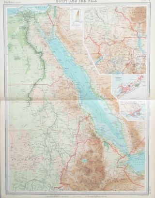
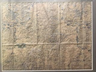
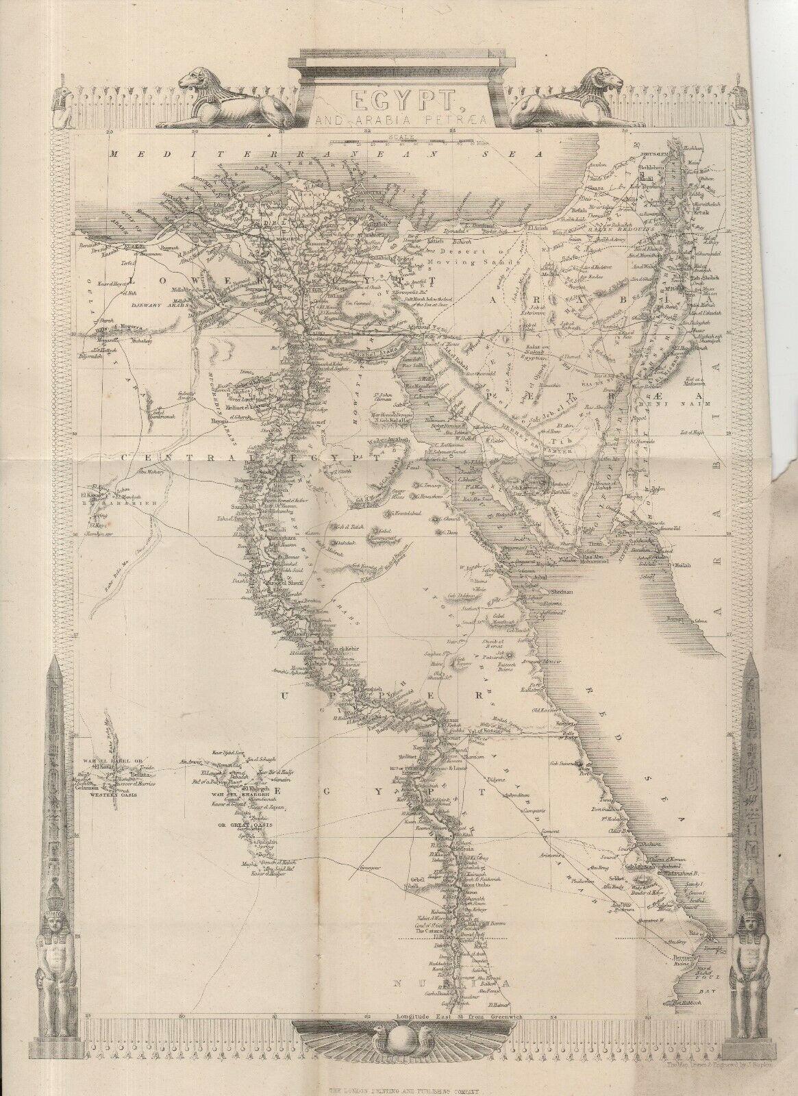
ANTIQUE JOHN RAPKIN MAP OF EGYPT, THE RED SEA & THE NILE - UNCOLOURED (c. 1860)


Item History & Price

Information:
Reference Number: Avaluer:20177235Map View: Egypt & The Nile
Type: Topographical MapCartographer/Publisher: John Rapkin
Year: 1860Printing Technique: Steel printed
Date Range: circa 1860Original/Reproduction: Original
Era: 1800sFormat: Folding Map
Original Description:
ANTIQUE MAP ......    of EGYPT, identifying the villages down the Nile and on the banks of The Red Sea, drawn by the eminent cartographer JOHN RAPKIN (1815-1876) who drew the maps for the ILUSTRATED ATLAS published by John Tallis at the time of The Great Exhibition (1851).   After Talis ceased trading, the Rapkin maps were republished by  The London Printing and Publishing Company - and this map bears their imprint.
This folding map came from a Victorian enyclopa...edia published circa 1860. In these days of the internet, these old encyclopaedias no longer have a commercial value - but whenever we come across an odd volume our family, who have been booksellers for seventy years, always save the maps - and this is one of the ones we have saved.
PAGE SIZE        380mmx275mm 
IN  VERY GOOD ANTIQUE CONDITION (with one sealed nick)


    Similar items


  • Map Of Egypt & The River Nile.  1922.  Africa.  Red Sea.  Sinai

    Map Of Egypt & The River Nile. 1922. Africa. Red Sea. Sinai

  • Antique 1887 Miniature Map Of Aden & The Seychelles By John Bartholomew

    Antique 1887 Miniature Map Of Aden & The Seychelles By John Bartholomew

  • 1892 John Bartholomew Map Of Cornwall & The Scilly Isles

    1892 John Bartholomew Map Of Cornwall & The Scilly Isles

  • Antique 17thc Engraved Map Of Zanzibar & The East African Coast By N.  Sanson

    Antique 17thc Engraved Map Of Zanzibar & The East African Coast By N. Sanson

  • Antique John Speed Map Of Staffordshire Print,  1610 Framed Print

    Antique John Speed Map Of Staffordshire Print, 1610 Framed Print

  • Antique 1899 Atlas Map Of Alaska & The Yukon Gold Fields/cuba,  Oversize

    Antique 1899 Atlas Map Of Alaska & The Yukon Gold Fields/cuba, Oversize

  • Antique Wwi German Map Of France & The Western Fronts 1914 To 1918 By Flemming

    Antique Wwi German Map Of France & The Western Fronts 1914 To 1918 By Flemming

  • 1672 John Chardin Map Of The Black Sea Circassia Persia Mingrelia Ukraine Turkey

    1672 John Chardin Map Of The Black Sea Circassia Persia Mingrelia Ukraine Turkey


    • You might also like


    • French Armillary Sphere Zodiac Orrery Solar System Space Astrology Astronomy

      French Armillary Sphere Zodiac Orrery Solar System Space Astrology Astronomy

    • 30” Antique Terrestrial Globe Manufactured By Weber Costello Co.

      30” Antique Terrestrial Globe Manufactured By Weber Costello Co.

    • Huge Vintage Military Aviation World Globe Denoyer Geppert Industrial - Antique

      Huge Vintage Military Aviation World Globe Denoyer Geppert Industrial - Antique

    • Denoyer Geppert 1940

      Denoyer Geppert 1940 ' S Vintage Chalkboard Globe -

    • Vintage Exceptional Trippensee Planetarium Complete,  All.

      Vintage Exceptional Trippensee Planetarium Complete, All.

    • Vintage Cram’s Universal Terrestrial Globe - 12 Inch

      Vintage Cram’s Universal Terrestrial Globe - 12 Inch

    • Antique 1880’s A.  H.  Andrews 6” Globe With Stand

      Antique 1880’s A. H. Andrews 6” Globe With Stand

    • 1763 Entick Map Colonial United States Canada Louisiana British Colonies Rare

      1763 Entick Map Colonial United States Canada Louisiana British Colonies Rare

Avaluer          About Us          Privacy Policy          Contact Us          UP
© 2022, avaluer.net, Inc. or its affiliates