1860 MITCHELL Hand Colored Map COLORADO, NEBRASKA & KANSAS - Civil War Era
Item History & Price
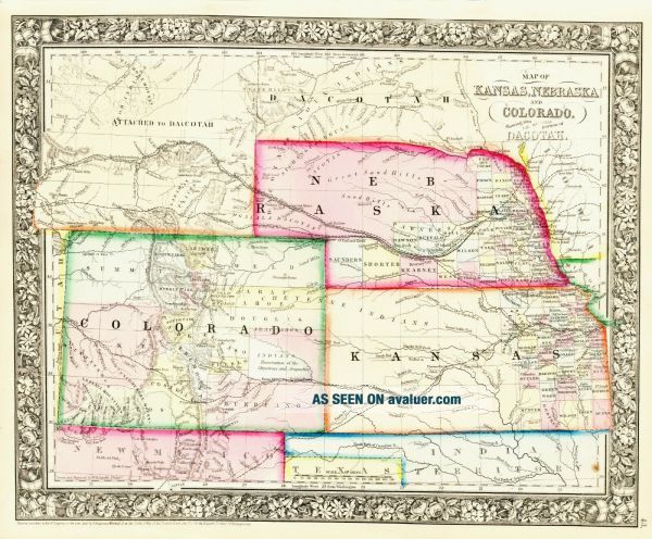
1861 Civil War Period Hand Colored Map of
COLORADO, KANSAS & NEBRASKA
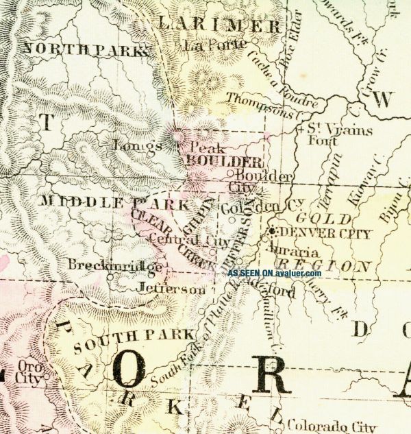
Detail of the Wagon Train Routes
An Amazing S. August Mitchell Work of Art An amazing hand colored map of Colorado, Kansas, Nebraska and parts of Idaho, Dakota Territory, Iowa, Indian Territory, Texas, New Mexico and a smidgen of Missouri and Utah dated 1861 produced during the American Civil War.
Entitled
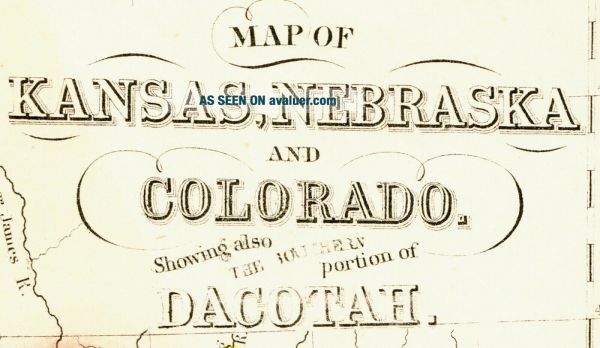
MAP OF
KANSAS, NEBRASKA
AND
COLORADO
...Showing also THE EASTERN portion of
IDAHO
This very nice map is from
MITCHELL'S
NEW GENERAL ATLAS
CONTAINING MAPS OF THE
VARIOUS COUNTRIES OF THE WORLD
PLANS OF CITIES, ETC.
EMBRACED IN
FIFTY-THREE QUARTO MAPS
FORMING A SERIES OF
EIGHTY-FOUR MAPS AND PLANS
TOGETHER WITH
VALUABLE STATISTICAL TABLES
PHILADELPHIA
PUBLISHED BY S. AUGUSTUS MITCHELL, JR
NO. 31 SOUTH SIXTH STREET.
1860
Entered according to Act of Congress in the year 186, by S. Augustus Mitchell, Jr. in the Clerk's Office of the District Court of the Eastern District of Pennsylvania
Of particular note are the immigrant trails. Many of the Indian tribes are identified including the Ogalala Dacotas Sioux, Cheyenne, Arapahoe and Crow. Each of the then existing counties is shown in separate hand color and are quite different than today. A gold region just east of Denver is identified. Idaho Territory at this time included all of Wyoming and Montana. The Pony Express had just ended but the Wagon Train routes through southwestern Nebraska heading up to Fort Laramie, then in Idaho Territory but in what would become Wyoming.
Nice size, the map is nearly 11½" by 14", with borders as issued.
A premier S. Augustus Mitchell map with no reserve.
Condition
In very good condition, there is one minor stain bottom right near the margin. This is a very nice and historic map. This is a must see/buy.
PLEASE CLICK HERE TO VISIT OUR STORE
for other fantastic items for sale
U.S. mail shipping, packing and handling charges are a flat $3.50 in the United States, international charges are $12.83.
This item is unconditionally guaranteed to be original and as described. We do not sell reproductions or copies.
We are proud of our outstanding feedback rating.
Thank you for bidding.
Westside Antiques Norman Riggs
7/12/2020
COLORADO, KANSAS & NEBRASKA
Detail of the Wagon Train Routes
An Amazing S. August Mitchell Work of Art An amazing hand colored map of Colorado, Kansas, Nebraska and parts of Idaho, Dakota Territory, Iowa, Indian Territory, Texas, New Mexico and a smidgen of Missouri and Utah dated 1861 produced during the American Civil War.
Entitled
MAP OF
KANSAS, NEBRASKA
AND
COLORADO
...Showing also THE EASTERN portion of
IDAHO
This very nice map is from
MITCHELL'S
NEW GENERAL ATLAS
CONTAINING MAPS OF THE
VARIOUS COUNTRIES OF THE WORLD
PLANS OF CITIES, ETC.
EMBRACED IN
FIFTY-THREE QUARTO MAPS
FORMING A SERIES OF
EIGHTY-FOUR MAPS AND PLANS
TOGETHER WITH
VALUABLE STATISTICAL TABLES
PHILADELPHIA
PUBLISHED BY S. AUGUSTUS MITCHELL, JR
NO. 31 SOUTH SIXTH STREET.
1860
Entered according to Act of Congress in the year 186, by S. Augustus Mitchell, Jr. in the Clerk's Office of the District Court of the Eastern District of Pennsylvania
Of particular note are the immigrant trails. Many of the Indian tribes are identified including the Ogalala Dacotas Sioux, Cheyenne, Arapahoe and Crow. Each of the then existing counties is shown in separate hand color and are quite different than today. A gold region just east of Denver is identified. Idaho Territory at this time included all of Wyoming and Montana. The Pony Express had just ended but the Wagon Train routes through southwestern Nebraska heading up to Fort Laramie, then in Idaho Territory but in what would become Wyoming.
Nice size, the map is nearly 11½" by 14", with borders as issued.
A premier S. Augustus Mitchell map with no reserve.
Condition
In very good condition, there is one minor stain bottom right near the margin. This is a very nice and historic map. This is a must see/buy.
PLEASE CLICK HERE TO VISIT OUR STORE
for other fantastic items for sale
U.S. mail shipping, packing and handling charges are a flat $3.50 in the United States, international charges are $12.83.
This item is unconditionally guaranteed to be original and as described. We do not sell reproductions or copies.
We are proud of our outstanding feedback rating.
Thank you for bidding.
Westside Antiques Norman Riggs
7/12/2020