Antique Vintage Tudor Blaeu Map Of Guinea, West Africa 1635 1600 ' S: REPRINT


Item History & Price

Information:
Reference Number: Avaluer:28832001Year: 1635
Type: County MapEra: 1600s
Original/Reproduction: Antique ReproductionCartographer/Publisher: blaeu
Date Range: 1600-1699
Original Description:
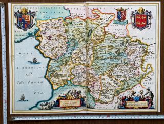
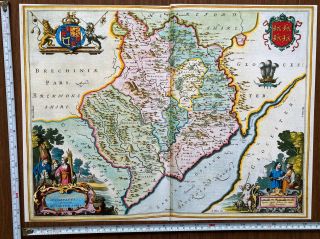
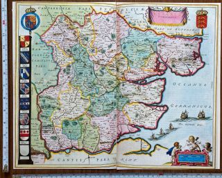
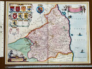
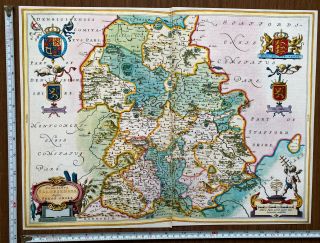
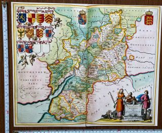
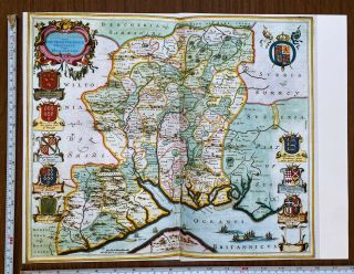
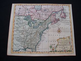
Map of Guinea, West Africa which was originally published in 1635 by William Blaeu who was a Dutch mapmaker. 
This map is a book plate taken very carefully from a book of 17th Century maps which was published in 1997.  It is printed on good quality paper but as it is from a book there is a fold in the middle of the page, check the photos for more details.  It measures approximately 44cm x 33cm and would look fabulous framed.A detailed description of the map is include...d with the map.   
PLEASE NOTE THAT THIS MAP IS NOT a PHOTOCOPY! 
The map has been kept in a sealed plastic bag and will be sent to you in a cardboard backed envelope.I have other maps for sale and will combine postage prices if you wish to buy any others.


    Similar items


  • Antique Vintage Tudor Blaeu Map Of Montgomery,  Merioneth,  Wales 1600

    Antique Vintage Tudor Blaeu Map Of Montgomery, Merioneth, Wales 1600 ' S: Reprint

  • Old Antique Vintage Tudor Blaeu Map Of Monmouthshire,  Wales 1665 1600

    Old Antique Vintage Tudor Blaeu Map Of Monmouthshire, Wales 1665 1600 ' S: Reprint

  • Old Antique Vintage Tudor Blaeu Map Of Essex England 1600

    Old Antique Vintage Tudor Blaeu Map Of Essex England 1600 ' S: Reprint 18. 5 " X 13

  • Old Antique Vintage Tudor Blaeu Map Of Northumberland,  England 1600

    Old Antique Vintage Tudor Blaeu Map Of Northumberland, England 1600 ' S: Reprint

  • Old Antique Vintage Tudor Blaeu Map Of Shropshire,  England 1665 1600

    Old Antique Vintage Tudor Blaeu Map Of Shropshire, England 1665 1600 ' S: Reprint

  • Old Antique Vintage Tudor Blaeu Map Of Gloucestershire,  England 1600

    Old Antique Vintage Tudor Blaeu Map Of Gloucestershire, England 1600 ' S: Reprint

  • Old Antique Vintage Tudor Blaeu Map Of Hampshire England 1665 1600

    Old Antique Vintage Tudor Blaeu Map Of Hampshire England 1665 1600 ' S: Reprint

  • Old Historic Antique Vintage Tudor Blaeu Map Of Cheshire England 1600

    Old Historic Antique Vintage Tudor Blaeu Map Of Cheshire England 1600 ' S: Reprint


    • You might also like


    • French Armillary Sphere Zodiac Orrery Solar System Space Astrology Astronomy

      French Armillary Sphere Zodiac Orrery Solar System Space Astrology Astronomy

    • 30” Antique Terrestrial Globe Manufactured By Weber Costello Co.

      30” Antique Terrestrial Globe Manufactured By Weber Costello Co.

    • Huge Vintage Military Aviation World Globe Denoyer Geppert Industrial - Antique

      Huge Vintage Military Aviation World Globe Denoyer Geppert Industrial - Antique

    • Denoyer Geppert 1940

      Denoyer Geppert 1940 ' S Vintage Chalkboard Globe -

    • Vintage Exceptional Trippensee Planetarium Complete,  All.

      Vintage Exceptional Trippensee Planetarium Complete, All.

    • Vintage Cram’s Universal Terrestrial Globe - 12 Inch

      Vintage Cram’s Universal Terrestrial Globe - 12 Inch

    • Antique 1880’s A.  H.  Andrews 6” Globe With Stand

      Antique 1880’s A. H. Andrews 6” Globe With Stand

    • 1763 Entick Map Colonial United States Canada Louisiana British Colonies Rare

      1763 Entick Map Colonial United States Canada Louisiana British Colonies Rare

Avaluer          About Us          Privacy Policy          Contact Us          UP
© 2022, avaluer.net, Inc. or its affiliates