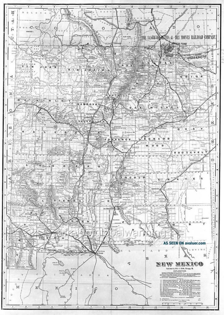
Print Ca 1904 " Map Of Mexico - Railroad Lines "


Item History & Price

Information:
Reference Number: Avaluer:3179061
Original Description:
Print.  Map of New Mexico showing state railroad lines.  ca 1904.                          You are purchasing a digital reproduction of the original image.  It has been produced using professional scanning equipment and skilled digital production technicians to optimize image quality.  The image you will receive will be printed on the highest ...quality archival photographic paper.  This is NOT an inkjet or dye-sub computer print but one produced in a traditional photographic wet process.  Paper surface finish is "E"(luster).The print you will receive will be 8x10 in size but due the the aspect ratio of some images there may be white borders so that no cropping will occur.Most images in our catalog are produced to order.  Please allow up to 4 business days for shipping.We also offer these images for purchase as a digital file for $75.  Larger sizes are available for some images. Please contact us for details. Although we do our best to provide accurate deatils including subject, date created and other specifics we cannot guarantee all details are accurate and assume no liability for errors in description. 


    Similar items


  • 1904 Antique Mexico Print/draining The Valley Of Mexico (the Great Canal)

    1904 Antique Mexico Print/draining The Valley Of Mexico (the Great Canal)

  • Vintage Hand Printed Tablecloth Map Of Mexico

    Vintage Hand Printed Tablecloth Map Of Mexico

  • 1946 Recreational Map Of Mexico Tourist Bureau Print Ad

    1946 Recreational Map Of Mexico Tourist Bureau Print Ad

  • Great Artistic Tourism & Cultural Map Of Mexico Jorge Escudero De Sybaris 27x36

    Great Artistic Tourism & Cultural Map Of Mexico Jorge Escudero De Sybaris 27x36

  • 1946 Recreational Map Of Mexico A Vacation Adventure Tourist Art Print Ad

    1946 Recreational Map Of Mexico A Vacation Adventure Tourist Art Print Ad

  • Illustrated Map Of Mexico City - 1969 - Map Poster

    Illustrated Map Of Mexico City - 1969 - Map Poster

  • War Map Of Mexico.  Showing The Strength Of Forces On Both Sides,  Ca 1916

    War Map Of Mexico. Showing The Strength Of Forces On Both Sides, Ca 1916

  • 1994: Map Of Mexico And The Caribbean Print

    1994: Map Of Mexico And The Caribbean Print


    • You might also like


    • 1930s China Sailor Photo Album 500 Photographs Hong Kong Shanghai,  Sino Japan War

      1930s China Sailor Photo Album 500 Photographs Hong Kong Shanghai, Sino Japan War

    • 1900s Historic China Boxer Rebels Executions Beheaded Glass Photo Negative - Bb

      1900s Historic China Boxer Rebels Executions Beheaded Glass Photo Negative - Bb

    • China Nanking Nanjing Chinese Girls Bounded Feet Street Scene Orig Photo ≈ 1902

      China Nanking Nanjing Chinese Girls Bounded Feet Street Scene Orig Photo ≈ 1902

    • Press Photo Fbi Agents With Thompson Sub Machine Guns Missouri

      Press Photo Fbi Agents With Thompson Sub Machine Guns Missouri

    • 1929 Funeral Dead Child Cute Little Girl Post Mortem Soviet Cp Antique Old Photo

      1929 Funeral Dead Child Cute Little Girl Post Mortem Soviet Cp Antique Old Photo

    • 1930 Funeral Child Lovely Young Girl Dead Coffin Post Mortem Ussr Vintage Photo

      1930 Funeral Child Lovely Young Girl Dead Coffin Post Mortem Ussr Vintage Photo

    • Full Plate Tintype Tall Ship Barque Vesta 1860s & Paper Frame

      Full Plate Tintype Tall Ship Barque Vesta 1860s & Paper Frame

    • China Chinese Girls Bounded Feet Studiophoto - Photo ≈ 1906

      China Chinese Girls Bounded Feet Studiophoto - Photo ≈ 1906

Avaluer          About Us          Privacy Policy          Contact Us          UP
© 2022, avaluer.net, Inc. or its affiliates