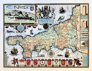
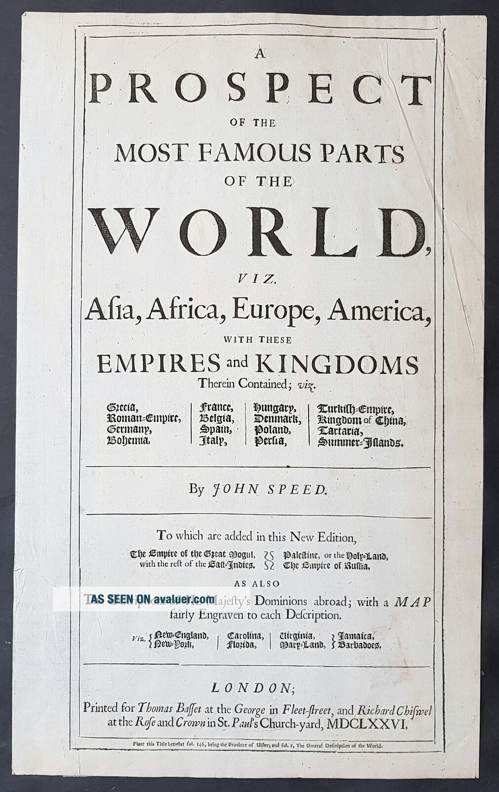
1676 John Speed Antique Letterpress Title Page To Speeds World Atlas
Item History & Price
| Reference Number: Avaluer:41474 |
contact us ebay profile ebay storeA Prospect of the most Famous Parts of the World.....by John Speed.....Printed for Thomas Bassett at the George in fleet-Street, and Richard Chiswell at the Rose and Crown in St Pauls Church-Yard MDCLXXVICartographer : - Speed, John 1551 - 1629 Date: - 1676 Size: - 16in x 10n (400mm x 255mm) Ref#: - 93109 Condition: - (A) Very Good ConditionDescription:
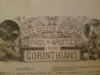
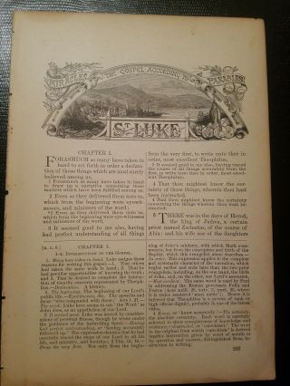
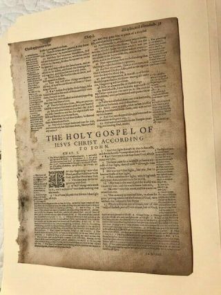
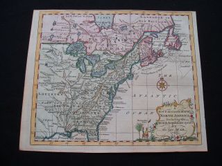
This original antique letterpress title page is from the 1676 Atlas A Prospect of the most Famous Parts... of the World by John Speed, printed for Thomas Bassett and Richard Chiswell, London.General Definitions:
Paper thickness and quality: - Light and stable
Paper color : - off white
Age of map color: -
Colors used: -
General color appearance: -
Paper size: - 16in x 10n (400mm x 255mm)
Plate size: - 16in x 10n (400mm x 255mm)
Margins: - Min 1/2in (12mm)Imperfections:
Margins: - Several small repairs on verso with archival tape
Plate area: - Several small repairs on verso with archival tape
Verso: - Several small repairs on verso with archival tapeBackground:
John Speed is perhaps the most famous single figure in the early history of the English map trade. He was a member of the Merchant Taylors Company, made free in September 1580, and later Fellow of the Society of Antiquaries. By training he was probably a rolling-press printer, but by interest he was a historian, and Queen Elizabeth granted him a sinecure in the Customs House, to give him the opportunity to pursue these interests.
His earliest cartographic publications were historical; in 1595, he published a wall map of the Holy Land, Canaan as it was Possessed both in Abraham and Israels Dayes, a two-sheet map of The Invasions of England and Ireland with all their Civill Warres since the Conquest (1601) and a wall map of England, Wales and Ireland showing the same information, [1603-1604].
In 1611 he prepared two Bible maps, the larger inserted in folio editions of the great King James Bible, the smaller in octavo printings; Speed also secured a privilege, dated 31st October 1610, to ensure that the map was inserted in every copy of the Bible sold, a lucrative arrangement that the Stationers Company eventually felt impelled to buy out from his heirs.
Speed always considered his History of Great Britaine (1611) his major work, but his reputation was established by the companion atlas volume, Theatre of the Empire of great Britaine, published in 1612, the first printed atlas of the British Isles. The earliest map prepared was The County Palatine of Chester [1604], but the death of the engraver William Rogers meant that Speeds publishers had to turn to Jodocus Hondius, an Amsterdam engraver, to prepare the maps.
The atlas was completed in 1612; the maps are notable for the decorative elements included, evidence of Speeds interest in antiquities and most have inset town-plans, the first series of printed town-plans of the British Isles, and were issued with descriptive English text printed on the verso. In the hands of different publishers, there were numerous editions to 1676 with text; later printings into the 1770s were issued without text.
Towards the end of his career, Speed also prepared a world atlas: the Prospect of the most Famous Parts of the World (1627), the first world atlas compiled by an Englishman and published in England, although the maps were engraved in Amsterdam, using Dutch models. Again, this was printed with English text on the verso, and reprinted thereafter. While early editions are rarer, perhaps the most important edition was the 1676 printing, which added newly prepared English maps of New England, Virginia, the Carolinas, Barbados and Jamaica.
Speeds publishers also prepared two pocket atlases, colloquially called miniature Speeds, reproducing the Theatre and Prospect on a smaller, less expensive, format. The county atlas, England, Wales, and Ireland: ... their several Counties abridged, first appeared in 1627, although there is an earlier proof version from about 1620; the A Prospect of the Most Famous Parts of the World appeared in 1646; both were reprinted in several editions up to 1675. However, Speed himself probably had little creative contribution to either atlas.Speed, John 1551 - 1629
Speed was an English cartographer and historian. He is, alongside Christopher Saxton, one of the best known English mapmakers of the early modern period.
Speed was born at Farndon, Cheshire and went into the tailoring business of his father, Samuel, later in life.
While working in London, Speed was a tailor and member of a corresponding guild, and came to the attention of learned individuals. These individuals included Sir Fulke Greville, who subsequently made him an allowance to enable him to devote his whole attention to research. By 1598 he had enough patronage to leave his manual labour job and engage in full-time scholarship. As a reward for his earlier efforts, Queen Elizabeth granted Speed the use of a room in the Custom House. Speed, was, by this point, as tailor turned scholar who had a highly developed pictorial sense.
In 1575, Speed married a woman named Susanna Draper in London, later having children with her. These children definitely included a son named John Speed, later a learned man with a doctorate, and an unknown number of others, since chroniclers and historians cannot agree on how many children they raised. Regardless, there is no doubt that the Speed family was relatively well-off.
By 1595, Speed published a map of biblical Canaan, in 1598 he presented his maps to Queen Elizabeth, and in 1611–1612 he published maps of Great Britain, with his son perhaps assisting Speed in surveys of English towns.
At age 77 or 78, in August 1629, Speed died. He was buried alongside his wife in Londons St Giles-without-Cripplegate church on Fore Street. Later on, a memorial to John Speed was also erected behind the altar of the church. According to the churchs website, [His was] one of the few memorials [in the church] that survived the bombing of London during The Blitz of 1940–1941 ... The website also notes that [t]he cast for the niche in which the bust is placed was provided by the Merchant Taylors Company, of which John Speed was a member. His memorial brass has ended up on display in the Burrell Collection near Glasgow.
Speed drew historical maps in 1601 and 1627 depicting the invasion of England and Ireland, depictions of the English Middle Ages, along with those depicting the current time, with rough originals but appealing, colourful final versions of his maps.
It was with the encouragement of William Camden that Speed began his Historie of Great Britaine, which was published in 1611. Although he probably had access to historical sources that are now lost to us (he certainly used the work of Saxton and Norden), his work as a historian is now considered secondary in importance to his map-making, of which his most important contribution is probably his town plans, many of which provide the first visual record of the British towns they depict. In the years leading up to this point, while his atlas was being compiled, he sent letters to Robert Cotton, part of the British government to ask for assistance in gathering necessary materials.
His atlas The Theatre of the Empire of Great Britaine was published in 1611 and 1612, and contained the first set of individual county maps of England and Wales besides maps of Ireland and a general map of Scotland. Tacked onto these maps was an introduction at the beginning when he addressed his well affected and favourable reader, which had numerous Christian and religious undertones, admitting that there may be errors, but he made it the best he could, and stated his purpose for the atlas:
..................my purpose...is to shew the situation of every Citie and Shire-town only [within Great Britain]...I have separated...[with] help of the tables...any Citie, Towne, Borough, Hamlet, or Place of Note...[it] may be affirmed, that there is not any one Kingdome in the world so exactly described...as is...Great Britaine...In shewing these things, I have chiefly sought to give satisfaction to all.............
With maps as proof impressions and printed from copper plates, detail was engraved in reverse with writing having to be put on the map the correct way, while speed copied, adapted and compiled the work of others, not doing much of the survey work on his own, which he acknowledged. The atlas was not above projections of his political opinions Speed represented King James I as one who unified the Kingdoms of the British isles. In 2016, the British Library published a book, introduced by former MP Nigel Nicolson and accompanied by commentaries by late medieval and early modern historian Alasdair Hawkyard, which reprinted this collection of maps on the British Isles, showing that Speed had drawn maps of areas ranging from Bedfordshire to Norfolk and Wales.
Most, but not all, of the county maps have town plans on them; those showing a Scale of Passes being the places he had mapped himself. In 1627, two years before his death, Speed published Prospect of the Most Famous Parts of the World which was the first world atlas produced by an Englishman, costing 40 shillings, meaning that its circulation was limited to richer customers and libraries, where many survive to this day.
There is a fascinating text describing the areas shown on the back of the maps in English, although a rare edition of 1616 of the British maps has a Latin text – this is believed to have been produced for the Continental market. Much of the engraving was done in Amsterdam at the workshop of a Flemish man named Jodocus Hondius, with whom he collaborated with from 1598 until 1612, with Hondiuss sudden death, a time period of 14 years. His maps of English and Welsh counties, often bordered with costumed figures ranging from nobility to country folk, are often found framed in homes throughout the United Kingdom.
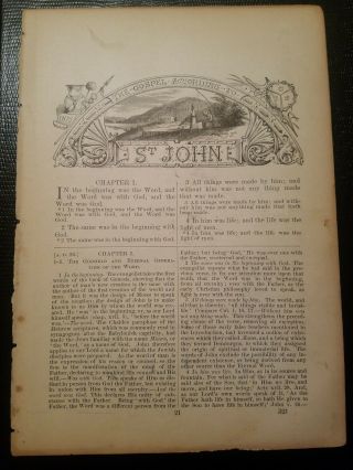
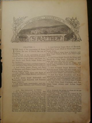
In 1611, he also published The genealogies recorded in the Sacred Scriptures according to euery family and tribe with the line of Our Sauior Jesus Christ obserued from Adam to the Blessed Virgin Mary, a biblical genealogy, reprinted several times during the 17th century. He also drew maps of the Channel Islands, Poland, and the Americas, the latter published only a few years before his death. On the year of his death, yet another collection of maps of Great Britain he had drawn the year before were published.
Described as a Protestant historian, Puritan historian or Protestant propagandist by some, Speed wrote about William Shakespeare, whom he called a Superlative Monster because of certain plays, Roman conquest, history of Chester, and explored early modern concepts of national identity. As these writings indicate, he possibly saw Wales as English and not an independent entity. More concretely, there is evidence that Speed, in his chronicling of history, uses theatrical metaphors and his developed historiographic skill to work while he repeats myths from medieval times as part of his story.
Since his maps were used in many high circles, Speeds legacy has been long-reaching. After his death, in 1673 and 1676, some of his other maps on the British isles, the Chesapeake Bay region, specifically of Virginia and Maryland, the East Indies, the Russian Empire then ruled by Peter the Great, Jamaica, and Barbados, among other locations. With these printings and others, Speeds maps became the basis for world maps until at least the mid-eighteenth century, with his maps reprinted many times, and served as a major contribution to British topography for years to come.
In later years, Speed would be called our English Mercator, a person of extraordinary industry and attainments in the study of antiques, an honest and impartial historian, a faithful Chronologer, and our Cheshire historian...a scholar...a distinguished writer on history. He was also called a celebrated chronologer and histographer, cartographer, and much more.
Even today, prints of his beautiful maps can be found in living rooms across the world, and sell for hundreds of thousands of pounds in rare art and map auctions, drawing in map collectors across the globe. Additionally, some use John Speeds maps, and connected commentary, to interpret William Shakespeares plays; however, Speed did not like Shakespeare in the slightest, and called him a papist
What is an Antique MapThe word Antique in the traditional sense refers to an item that is more than a hundred years old. In the past maps were sold in two forms, as a single sheet (broadsheet) or bound in an atlas or book. The majority of antique maps for sale today come from books or atlases and have survived due to the protection offered by the hardback covers.When considering a purchase The first thing to determine when staring a collection or purchasing an item, is what is important to you. Most collectors prefer to build their collections around a theme. You may decide to collect maps from one region or country, charting its development through time. Similarly you could collect maps of one particular period in time, by type (i.e. sea or celestial charts) or by cartographer. The collector might also want to consider the theme of cartographical misconceptions such as California as an island or Australia as Terra Australis or the Great Southern Land.
The subject is so wide that any would-be-collector has almost endless possibilities to find his own little niche within the field, and thereby build a rewarding collection.Starting a collection & pricingPricing is based on a number of different factors, the most important of which is regional. In any series of maps the most valuable are usually the World Map and the America/North America. The World because it is usually the most decorative and America because it has the strongest regional market. Other factors that come into play re: price is rarity, age, size, historical importance, decorative value (colour) and overall condition and quality of paper it is printed on.
As specialised dealers, we frequently work with first time map buyers who are just starting their collection. Guiding new collectors on their first antique map purchase and helping new collectors to focus their interests is one of the most rewarding aspects of being an rare map dealer. So please do not hesitate to contact us and we will be happy to help with any questions you may have.Payment, Shipping & Return OptionsPlease click on the \"Shipping and Payments\" Tab above for shipping, payment and return detailsAbout USClassical Images was founded 1998 and has built an excellent reputation for supplying high quality original antiquarian maps, historical atlases, antique books and prints. We carry an extensive inventory of antiquarian collectibles from the 15th to 19th century. Our collection typically includes rare books and decorative antique maps and prints by renowned cartographers, authors and engravers. Specific items not listed may be sourced on request.
Classical Images adheres to the Codes of Ethics outlined by the Antiquarian Booksellers Association of America (ABAA).
We are a primarily an online based enterprise, however our inventory may be viewed by appointment. Please call or email to arrange a viewing.
This original antique letterpress title page is from the 1676 Atlas A Prospect of the most Famous Parts... of the World by John Speed, printed for Thomas Bassett and Richard Chiswell, London.General Definitions:
Paper thickness and quality: - Light and stable
Paper color : - off white
Age of map color: -
Colors used: -
General color appearance: -
Paper size: - 16in x 10n (400mm x 255mm)
Plate size: - 16in x 10n (400mm x 255mm)
Margins: - Min 1/2in (12mm)Imperfections:
Margins: - Several small repairs on verso with archival tape
Plate area: - Several small repairs on verso with archival tape
Verso: - Several small repairs on verso with archival tapeBackground:
John Speed is perhaps the most famous single figure in the early history of the English map trade. He was a member of the Merchant Taylors Company, made free in September 1580, and later Fellow of the Society of Antiquaries. By training he was probably a rolling-press printer, but by interest he was a historian, and Queen Elizabeth granted him a sinecure in the Customs House, to give him the opportunity to pursue these interests.
His earliest cartographic publications were historical; in 1595, he published a wall map of the Holy Land, Canaan as it was Possessed both in Abraham and Israels Dayes, a two-sheet map of The Invasions of England and Ireland with all their Civill Warres since the Conquest (1601) and a wall map of England, Wales and Ireland showing the same information, [1603-1604].
In 1611 he prepared two Bible maps, the larger inserted in folio editions of the great King James Bible, the smaller in octavo printings; Speed also secured a privilege, dated 31st October 1610, to ensure that the map was inserted in every copy of the Bible sold, a lucrative arrangement that the Stationers Company eventually felt impelled to buy out from his heirs.
Speed always considered his History of Great Britaine (1611) his major work, but his reputation was established by the companion atlas volume, Theatre of the Empire of great Britaine, published in 1612, the first printed atlas of the British Isles. The earliest map prepared was The County Palatine of Chester [1604], but the death of the engraver William Rogers meant that Speeds publishers had to turn to Jodocus Hondius, an Amsterdam engraver, to prepare the maps.
The atlas was completed in 1612; the maps are notable for the decorative elements included, evidence of Speeds interest in antiquities and most have inset town-plans, the first series of printed town-plans of the British Isles, and were issued with descriptive English text printed on the verso. In the hands of different publishers, there were numerous editions to 1676 with text; later printings into the 1770s were issued without text.
Towards the end of his career, Speed also prepared a world atlas: the Prospect of the most Famous Parts of the World (1627), the first world atlas compiled by an Englishman and published in England, although the maps were engraved in Amsterdam, using Dutch models. Again, this was printed with English text on the verso, and reprinted thereafter. While early editions are rarer, perhaps the most important edition was the 1676 printing, which added newly prepared English maps of New England, Virginia, the Carolinas, Barbados and Jamaica.
Speeds publishers also prepared two pocket atlases, colloquially called miniature Speeds, reproducing the Theatre and Prospect on a smaller, less expensive, format. The county atlas, England, Wales, and Ireland: ... their several Counties abridged, first appeared in 1627, although there is an earlier proof version from about 1620; the A Prospect of the Most Famous Parts of the World appeared in 1646; both were reprinted in several editions up to 1675. However, Speed himself probably had little creative contribution to either atlas.Speed, John 1551 - 1629
Speed was an English cartographer and historian. He is, alongside Christopher Saxton, one of the best known English mapmakers of the early modern period.
Speed was born at Farndon, Cheshire and went into the tailoring business of his father, Samuel, later in life.
While working in London, Speed was a tailor and member of a corresponding guild, and came to the attention of learned individuals. These individuals included Sir Fulke Greville, who subsequently made him an allowance to enable him to devote his whole attention to research. By 1598 he had enough patronage to leave his manual labour job and engage in full-time scholarship. As a reward for his earlier efforts, Queen Elizabeth granted Speed the use of a room in the Custom House. Speed, was, by this point, as tailor turned scholar who had a highly developed pictorial sense.
In 1575, Speed married a woman named Susanna Draper in London, later having children with her. These children definitely included a son named John Speed, later a learned man with a doctorate, and an unknown number of others, since chroniclers and historians cannot agree on how many children they raised. Regardless, there is no doubt that the Speed family was relatively well-off.
By 1595, Speed published a map of biblical Canaan, in 1598 he presented his maps to Queen Elizabeth, and in 1611–1612 he published maps of Great Britain, with his son perhaps assisting Speed in surveys of English towns.
At age 77 or 78, in August 1629, Speed died. He was buried alongside his wife in Londons St Giles-without-Cripplegate church on Fore Street. Later on, a memorial to John Speed was also erected behind the altar of the church. According to the churchs website, [His was] one of the few memorials [in the church] that survived the bombing of London during The Blitz of 1940–1941 ... The website also notes that [t]he cast for the niche in which the bust is placed was provided by the Merchant Taylors Company, of which John Speed was a member. His memorial brass has ended up on display in the Burrell Collection near Glasgow.
Speed drew historical maps in 1601 and 1627 depicting the invasion of England and Ireland, depictions of the English Middle Ages, along with those depicting the current time, with rough originals but appealing, colourful final versions of his maps.
It was with the encouragement of William Camden that Speed began his Historie of Great Britaine, which was published in 1611. Although he probably had access to historical sources that are now lost to us (he certainly used the work of Saxton and Norden), his work as a historian is now considered secondary in importance to his map-making, of which his most important contribution is probably his town plans, many of which provide the first visual record of the British towns they depict. In the years leading up to this point, while his atlas was being compiled, he sent letters to Robert Cotton, part of the British government to ask for assistance in gathering necessary materials.
His atlas The Theatre of the Empire of Great Britaine was published in 1611 and 1612, and contained the first set of individual county maps of England and Wales besides maps of Ireland and a general map of Scotland. Tacked onto these maps was an introduction at the beginning when he addressed his well affected and favourable reader, which had numerous Christian and religious undertones, admitting that there may be errors, but he made it the best he could, and stated his purpose for the atlas:
..................my purpose...is to shew the situation of every Citie and Shire-town only [within Great Britain]...I have separated...[with] help of the tables...any Citie, Towne, Borough, Hamlet, or Place of Note...[it] may be affirmed, that there is not any one Kingdome in the world so exactly described...as is...Great Britaine...In shewing these things, I have chiefly sought to give satisfaction to all.............
With maps as proof impressions and printed from copper plates, detail was engraved in reverse with writing having to be put on the map the correct way, while speed copied, adapted and compiled the work of others, not doing much of the survey work on his own, which he acknowledged. The atlas was not above projections of his political opinions Speed represented King James I as one who unified the Kingdoms of the British isles. In 2016, the British Library published a book, introduced by former MP Nigel Nicolson and accompanied by commentaries by late medieval and early modern historian Alasdair Hawkyard, which reprinted this collection of maps on the British Isles, showing that Speed had drawn maps of areas ranging from Bedfordshire to Norfolk and Wales.
Most, but not all, of the county maps have town plans on them; those showing a Scale of Passes being the places he had mapped himself. In 1627, two years before his death, Speed published Prospect of the Most Famous Parts of the World which was the first world atlas produced by an Englishman, costing 40 shillings, meaning that its circulation was limited to richer customers and libraries, where many survive to this day.
There is a fascinating text describing the areas shown on the back of the maps in English, although a rare edition of 1616 of the British maps has a Latin text – this is believed to have been produced for the Continental market. Much of the engraving was done in Amsterdam at the workshop of a Flemish man named Jodocus Hondius, with whom he collaborated with from 1598 until 1612, with Hondiuss sudden death, a time period of 14 years. His maps of English and Welsh counties, often bordered with costumed figures ranging from nobility to country folk, are often found framed in homes throughout the United Kingdom.
In 1611, he also published The genealogies recorded in the Sacred Scriptures according to euery family and tribe with the line of Our Sauior Jesus Christ obserued from Adam to the Blessed Virgin Mary, a biblical genealogy, reprinted several times during the 17th century. He also drew maps of the Channel Islands, Poland, and the Americas, the latter published only a few years before his death. On the year of his death, yet another collection of maps of Great Britain he had drawn the year before were published.
Described as a Protestant historian, Puritan historian or Protestant propagandist by some, Speed wrote about William Shakespeare, whom he called a Superlative Monster because of certain plays, Roman conquest, history of Chester, and explored early modern concepts of national identity. As these writings indicate, he possibly saw Wales as English and not an independent entity. More concretely, there is evidence that Speed, in his chronicling of history, uses theatrical metaphors and his developed historiographic skill to work while he repeats myths from medieval times as part of his story.
Since his maps were used in many high circles, Speeds legacy has been long-reaching. After his death, in 1673 and 1676, some of his other maps on the British isles, the Chesapeake Bay region, specifically of Virginia and Maryland, the East Indies, the Russian Empire then ruled by Peter the Great, Jamaica, and Barbados, among other locations. With these printings and others, Speeds maps became the basis for world maps until at least the mid-eighteenth century, with his maps reprinted many times, and served as a major contribution to British topography for years to come.
In later years, Speed would be called our English Mercator, a person of extraordinary industry and attainments in the study of antiques, an honest and impartial historian, a faithful Chronologer, and our Cheshire historian...a scholar...a distinguished writer on history. He was also called a celebrated chronologer and histographer, cartographer, and much more.
Even today, prints of his beautiful maps can be found in living rooms across the world, and sell for hundreds of thousands of pounds in rare art and map auctions, drawing in map collectors across the globe. Additionally, some use John Speeds maps, and connected commentary, to interpret William Shakespeares plays; however, Speed did not like Shakespeare in the slightest, and called him a papist
What is an Antique MapThe word Antique in the traditional sense refers to an item that is more than a hundred years old. In the past maps were sold in two forms, as a single sheet (broadsheet) or bound in an atlas or book. The majority of antique maps for sale today come from books or atlases and have survived due to the protection offered by the hardback covers.When considering a purchase The first thing to determine when staring a collection or purchasing an item, is what is important to you. Most collectors prefer to build their collections around a theme. You may decide to collect maps from one region or country, charting its development through time. Similarly you could collect maps of one particular period in time, by type (i.e. sea or celestial charts) or by cartographer. The collector might also want to consider the theme of cartographical misconceptions such as California as an island or Australia as Terra Australis or the Great Southern Land.
The subject is so wide that any would-be-collector has almost endless possibilities to find his own little niche within the field, and thereby build a rewarding collection.Starting a collection & pricingPricing is based on a number of different factors, the most important of which is regional. In any series of maps the most valuable are usually the World Map and the America/North America. The World because it is usually the most decorative and America because it has the strongest regional market. Other factors that come into play re: price is rarity, age, size, historical importance, decorative value (colour) and overall condition and quality of paper it is printed on.
As specialised dealers, we frequently work with first time map buyers who are just starting their collection. Guiding new collectors on their first antique map purchase and helping new collectors to focus their interests is one of the most rewarding aspects of being an rare map dealer. So please do not hesitate to contact us and we will be happy to help with any questions you may have.Payment, Shipping & Return OptionsPlease click on the \"Shipping and Payments\" Tab above for shipping, payment and return detailsAbout USClassical Images was founded 1998 and has built an excellent reputation for supplying high quality original antiquarian maps, historical atlases, antique books and prints. We carry an extensive inventory of antiquarian collectibles from the 15th to 19th century. Our collection typically includes rare books and decorative antique maps and prints by renowned cartographers, authors and engravers. Specific items not listed may be sourced on request.
Classical Images adheres to the Codes of Ethics outlined by the Antiquarian Booksellers Association of America (ABAA).
We are a primarily an online based enterprise, however our inventory may be viewed by appointment. Please call or email to arrange a viewing.