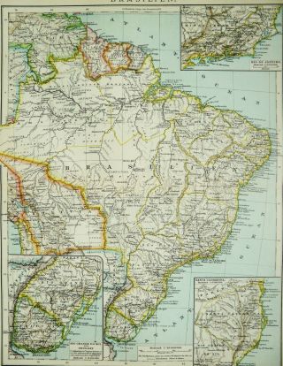
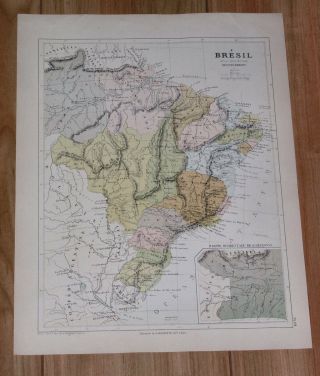
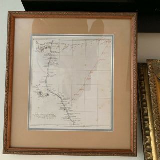
Antique Map Of Brazil Brasil Brasilia By Pierre Duval From 1685


Item History & Price

Information:
Reference Number: Avaluer:59675173Cartographer/Publisher: Pierre Duval
Year: 1685Original/Reproduction: Antique Original
Country/Region: Brazil
Original Description:
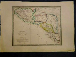
Free eBay listing template designed by dewiso.comBrasilia – Pierre DuvalEarly miniature map of Brazil, including the mythical Lake Parime/Parima. From a German edition of Pierre Duval’s pocket world geography. Published by Johann Hoffman, and possibly engraved by Sigismund G. Hipschman.Title: Brasilia
Date: 1685
Size: 10.0 x 12.2 cm
Condition: Very Good (VG)M. Rasmussen Antique Maps, Books & PrintsWe are an online based antique map dealer with focus on maps from the 16...th to the 18th century. We also feature antique books and prints. Our goal is to offer rare, decorative and interesting items, while providing excellent service and guidance.Worldwide delivery (we ship within 2-5 business days)Only original antique Maps, Books & PrintsSign up to our newsletter for updates on new arrivalsM. Rasmussen Maps, Books & Prints (VAT DK38576593)
Ejbyvej 10, 4700 Næstved, Denmark


    Similar items


  • 1895 Antique Map Of Brazil.  Brasil.  Rio De Janeiro.  Sao Paulo.  South America.

    1895 Antique Map Of Brazil. Brasil. Rio De Janeiro. Sao Paulo. South America.

  • Antique Map Of The United States By: David Burr,  1835

    Antique Map Of The United States By: David Burr, 1835

  • 1850 - Illustrated Antique Map Of " The Crimea " Turkey By Tallis (74d)

    1850 - Illustrated Antique Map Of " The Crimea " Turkey By Tallis (74d)

  • Georgian Antique Map Of Hertfordshire Middlesex & London By C Smith 1822

    Georgian Antique Map Of Hertfordshire Middlesex & London By C Smith 1822

  • 1871 Antique Map Of France,  Spain,  Portugal,  By S.  Augustus Mitchell

    1871 Antique Map Of France, Spain, Portugal, By S. Augustus Mitchell

  • 1878 Antique Map Of Brazil / South America

    1878 Antique Map Of Brazil / South America

  • Antique Map Of The United States By: Warner & Beers,  1872

    Antique Map Of The United States By: Warner & Beers, 1872

  • Antique Map Of The United States By: Rand Mcnally,  1880

    Antique Map Of The United States By: Rand Mcnally, 1880


    • You might also like


    • Extremely Rare Photo Of Hong Kong,  Showing Central Victoria Township 1857

      Extremely Rare Photo Of Hong Kong, Showing Central Victoria Township 1857

    • 1860: Manuscript Map Of Hms Vixen Chile / Peru

      1860: Manuscript Map Of Hms Vixen Chile / Peru

    • Rare Antique G.  W.  Bromley & Co 1891 City Of South Boston Mass Atlas 33 Plates

      Rare Antique G. W. Bromley & Co 1891 City Of South Boston Mass Atlas 33 Plates

    • 1893 Atlas Map Plat Turner County South Dakota Rowley & Peterson Antique Vtg.

      1893 Atlas Map Plat Turner County South Dakota Rowley & Peterson Antique Vtg.

    • Antique Map Of Guatemala Or United States Of Central America

      Antique Map Of Guatemala Or United States Of Central America

    • U.  S Geological Survey Authentic Rubber Stamp 1986 South Pole

      U. S Geological Survey Authentic Rubber Stamp 1986 South Pole

    • South America; Brazil,  Santa Catarina Island - Bellin - 1751 - 1760

      South America; Brazil, Santa Catarina Island - Bellin - 1751 - 1760

    • Map; Mexico & Central America - Map Of West Indies 1887

      Map; Mexico & Central America - Map Of West Indies 1887

Avaluer          About Us          Privacy Policy          Contact Us          UP
© 2022, avaluer.net, Inc. or its affiliates