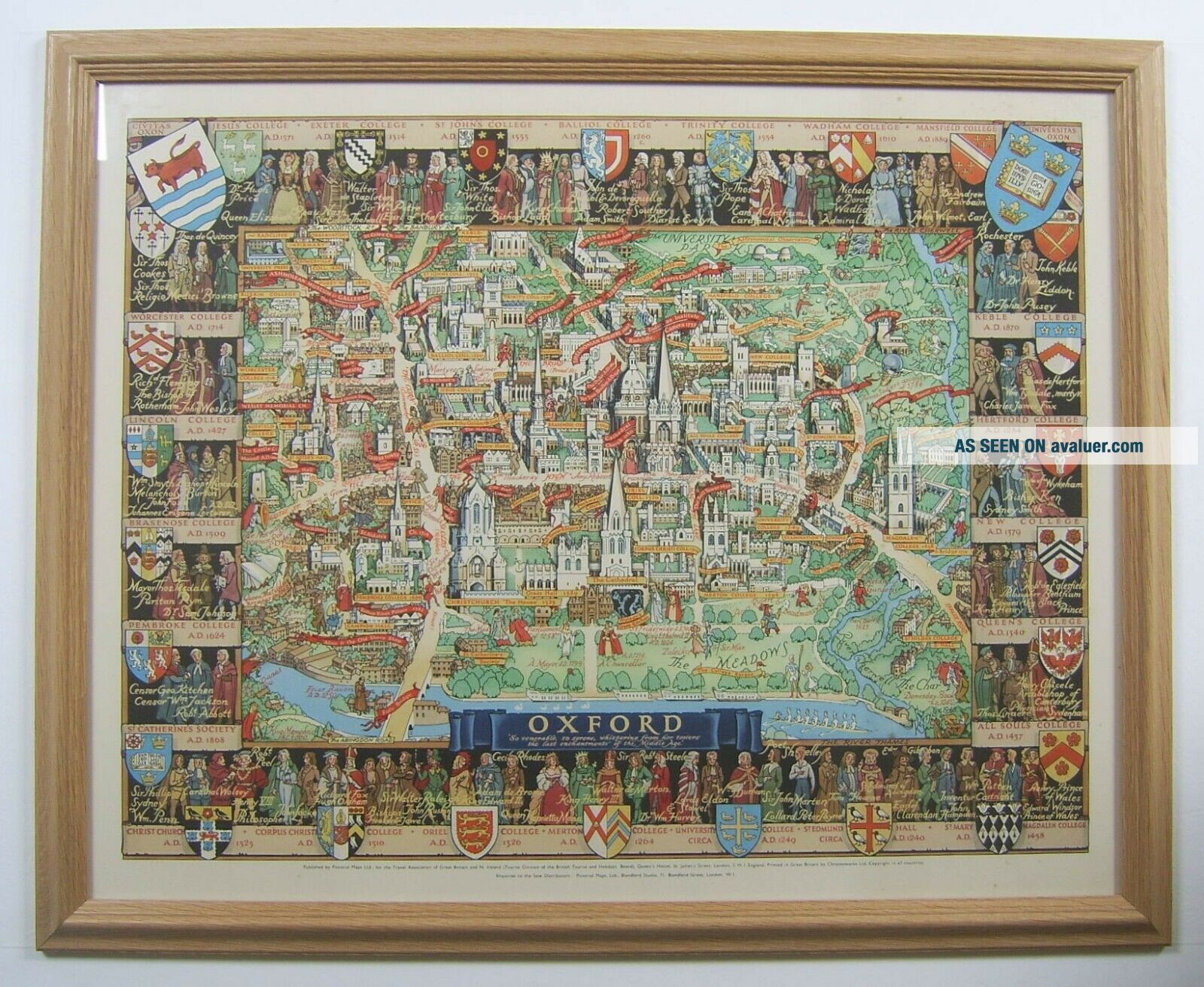
Oxford: Vintage City Plan By Kerry Lee, C1948


Item History & Price

Information:
Reference Number: Avaluer:10119Printing Technique: Lithography
Country/Region: EnglandOriginal/Reproduction: Vintage Original
Era: 1940s
Original Description:
An original pictorial, lithographic plan of OXFORD by Kerry Lee. Published by Pictorial Maps Ltd c1948. This highly detailed and colourful plan provides bird's eye view of the city combining historical and contemporary information with gentle humour. The plan is framed (560x685mm), unmounted and has a printed area approximately 440x580mm. The item is in excellent condition. NB this item will be sold out-of-frame to international buyers.


    Similar items


  • Cambridge: Vintage Pictorial Map By Kerry Lee,  C1948

    Cambridge: Vintage Pictorial Map By Kerry Lee, C1948

  • Vintage City Plan Of Yokohama Reprinted By Bmp U.  S.  Army 1945

    Vintage City Plan Of Yokohama Reprinted By Bmp U. S. Army 1945

  • 4 Vintage Dave Robicheaux Novels - James Lee Burke - Paperbacks -

    4 Vintage Dave Robicheaux Novels - James Lee Burke - Paperbacks -

  • 2 Vintage Dave Robicheaux Novels - James Lee Burke - Paperbacks -

    2 Vintage Dave Robicheaux Novels - James Lee Burke - Paperbacks -

  • 1932 Vintage Map Bath Somerset City Plan By Alfred E.  Taylor

    1932 Vintage Map Bath Somerset City Plan By Alfred E. Taylor

  • Oxford & Cambridge.  Town/city Plan By Jw Lowry For The Dispatch Atlas 1863 Map

    Oxford & Cambridge. Town/city Plan By Jw Lowry For The Dispatch Atlas 1863 Map

  • 1936 Vintage Map Bath City Plan By Alfred Taylor Roads

    1936 Vintage Map Bath City Plan By Alfred Taylor Roads

  • The Incredible Hulk Vintage Poster Signed By Stan Lee 1985

    The Incredible Hulk Vintage Poster Signed By Stan Lee 1985


    • You might also like


    • Hungary & Romania 1579 (1584) Ortelius Unusual Antique Copper Engraved Map

      Hungary & Romania 1579 (1584) Ortelius Unusual Antique Copper Engraved Map

    • Brussels Bruxelles Belfium 1777 De Ferraris & Dupuis Large Antique Map Sheet Xxi

      Brussels Bruxelles Belfium 1777 De Ferraris & Dupuis Large Antique Map Sheet Xxi

    • 1616 Atlas Map Of Iceland.

      1616 Atlas Map Of Iceland.

    • Kazan Russia 1767 Le Clerc/lespinasse Antique Copper Engraved City View

      Kazan Russia 1767 Le Clerc/lespinasse Antique Copper Engraved City View

    • 1899 Stanford,  Folding Map Of Norwich,  Norfolk,  Arthur Collins,  Jarrold & Sons,

      1899 Stanford, Folding Map Of Norwich, Norfolk, Arthur Collins, Jarrold & Sons,

    • 1948 Vintage Linen Colour Map Geological Survey Ten Mile Of Great Britain

      1948 Vintage Linen Colour Map Geological Survey Ten Mile Of Great Britain

    • 1944 Map Flying Bombs Sussex Ww2 Newspaper Military Kent Courier German V1 V2

      1944 Map Flying Bombs Sussex Ww2 Newspaper Military Kent Courier German V1 V2

    • Dated 1638 Vellum Map Of Icklesham Sussex Showing Land Uses Owners Etc

      Dated 1638 Vellum Map Of Icklesham Sussex Showing Land Uses Owners Etc

Avaluer          About Us          Privacy Policy          Contact Us          UP
© 2022, avaluer.net, Inc. or its affiliates