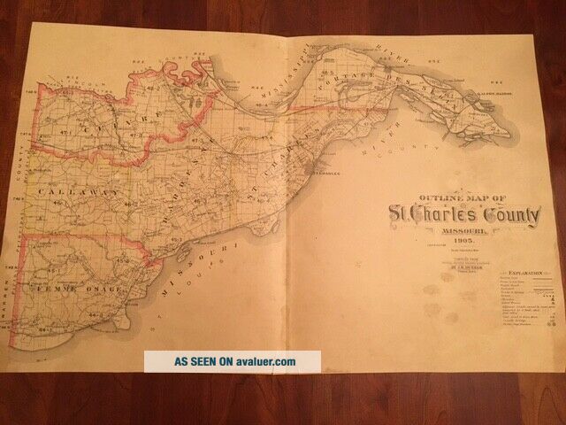
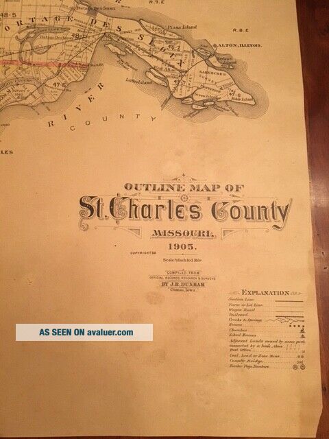
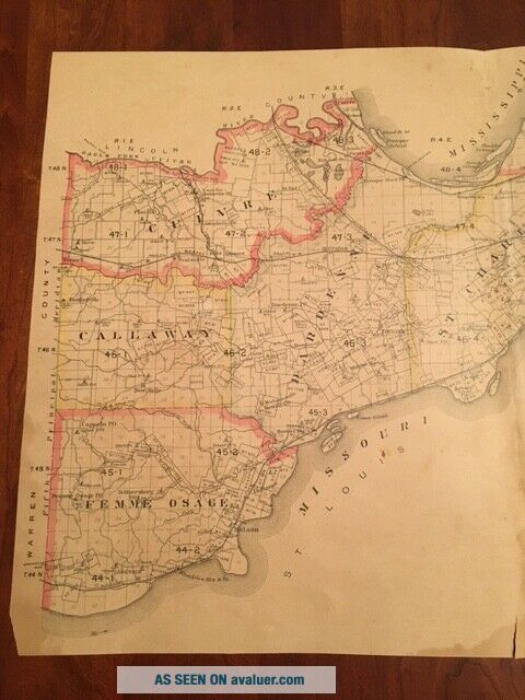
RARE 1905 Outline Map Of St. Charles County MISSOURI Railroads Wagon Roads River


Item History & Price

Information:
Reference Number: Avaluer:10697Format: Atlas Map
US State: MissouriType: County Map
Date Range: 1900-1909Year: 1905
Country/Region: United States of America
Original Description:
1905 Outline Map of St. Charles County, Missouri : compiled from county records and actual surveysCreated / PublishedJ.R. Dunham, Clinton, Iowa, 1905.Measures 15-1/2" x 24"  One fold in the middle.  Paper toned, but great condition.  A few small closed tears.  Perfect for framing!I've done my best to describe the map, but if you have additional questions, please don't hesitate to send me an e-mail.


    Similar items


  • Very Rare 1862 Confederate Parish Of St.  Charles Louisiana $1

    Very Rare 1862 Confederate Parish Of St. Charles Louisiana $1

  • Rare Vintage Print - Map Of St Andrews Golf Course

    Rare Vintage Print - Map Of St Andrews Golf Course

  • Vintage 1885 History Of St.  Charles,  Montgomery & Warren Counties Missouri Rare

    Vintage 1885 History Of St. Charles, Montgomery & Warren Counties Missouri Rare

  • Rare Chas.  Hoelscher

    Rare Chas. Hoelscher ' S Official City Guide & 1928 Map Of St. Louis Great History

  • Vintage 1906 Charles Foster Kent Map Of St Paul

    Vintage 1906 Charles Foster Kent Map Of St Paul ' S Journeys

  • 1905 Rare Antique Russian Map Of Vicinity Of Rome / Italy

    1905 Rare Antique Russian Map Of Vicinity Of Rome / Italy

  • 1905 Rare Antique Russian Map Of Vienna Wien Austria With Places Streets Index

    1905 Rare Antique Russian Map Of Vienna Wien Austria With Places Streets Index

  • 1905 2nd Ed.  Os 6 Inches To A Mile Map Of Devonshire – Charles & High Bray Xivne

    1905 2nd Ed. Os 6 Inches To A Mile Map Of Devonshire – Charles & High Bray Xivne


    • You might also like


    • 1860 Mitchell Hand Colored Map Colorado,  Nebraska & Kansas - Civil War Era

      1860 Mitchell Hand Colored Map Colorado, Nebraska & Kansas - Civil War Era

    • 18th Century French Map Of North America

      18th Century French Map Of North America

    • Las Vegas Nevada Vintage 1967 Us Geological Survey Quadrangle Map 4 Panels

      Las Vegas Nevada Vintage 1967 Us Geological Survey Quadrangle Map 4 Panels

    • Rare Antique 1845 Maps United States Exploring Expedition Book Antartica Hawaii

      Rare Antique 1845 Maps United States Exploring Expedition Book Antartica Hawaii

    • Vintage 1926 Map Hollywood From The Best Surveys Of The Time

      Vintage 1926 Map Hollywood From The Best Surveys Of The Time

    • American Continent (western Hemisphere) 1747 Bowen Antique Copper Engraved Map

      American Continent (western Hemisphere) 1747 Bowen Antique Copper Engraved Map

    • Gulf Coast Florida Texas United States 1705 De Fer Unusual Antique Engraved Map

      Gulf Coast Florida Texas United States 1705 De Fer Unusual Antique Engraved Map

    • California As Island United States 1700 De Fer Unusual First Edition Antique Map

      California As Island United States 1700 De Fer Unusual First Edition Antique Map

Avaluer          About Us          Privacy Policy          Contact Us          UP
© 2022, avaluer.net, Inc. or its affiliates