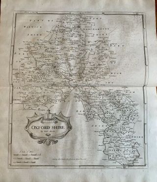
Oxfordshire: Antique Map By Robert Plot 1677


Item History & Price

Information:
Reference Number: Avaluer:11337Map Type: Regional/ Local
County: OxfordshireAntique/ Modern: Antique
Original/Reproduction: Antique OriginalDate Range: 1600-1699
Era: 1600sPrinting Technique: Copper Plate
Original Description:
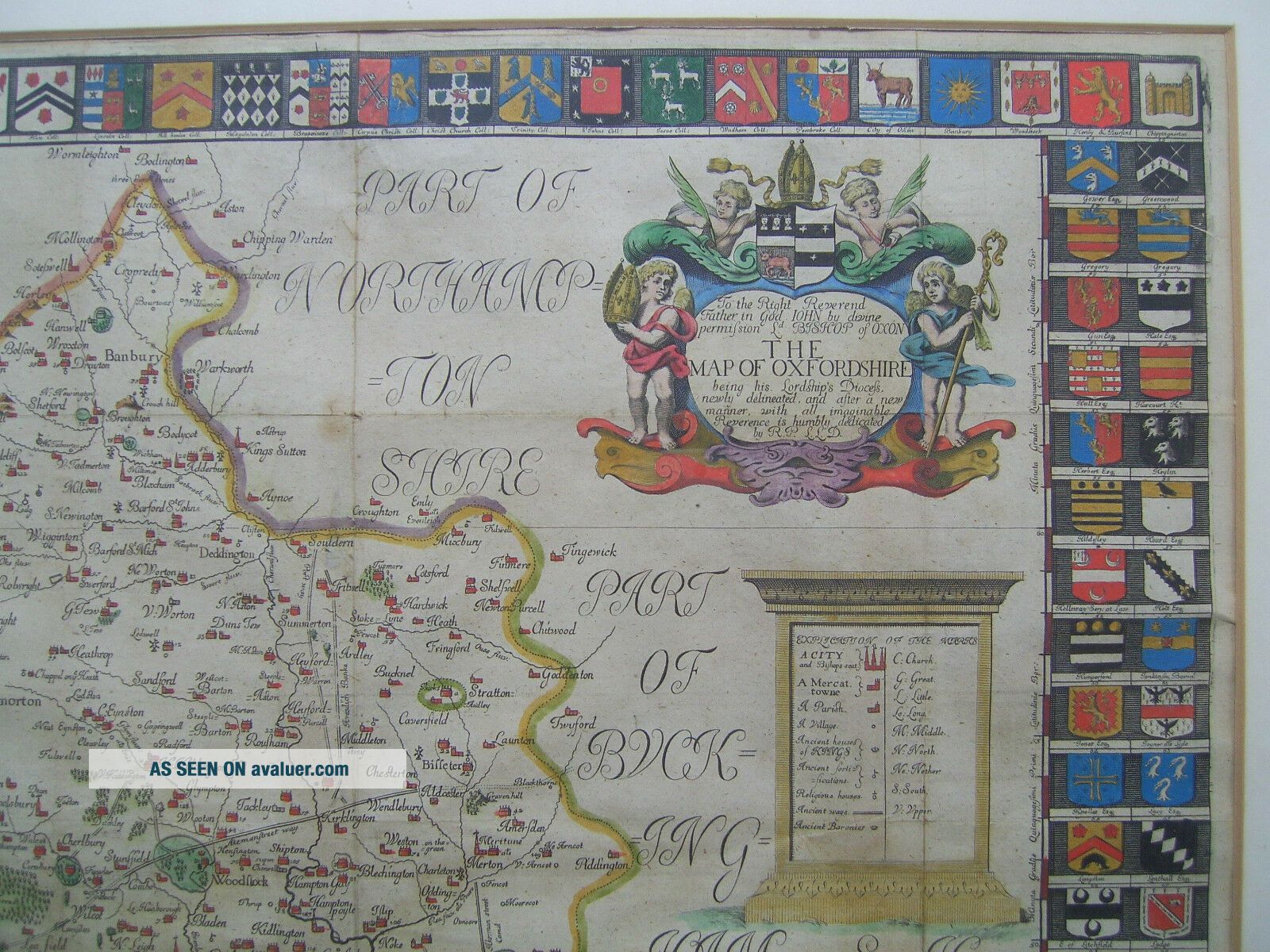
An original and scarce map of Oxfordshire (The Map of Oxfordshire) by Robert Plot (first Keeper of the Ashmolean Museum). First published in Plot's Natural History of Oxfordshire in 1677, the map was engraved by Michael Burghers. The map is framed (680x710mm), mounted (printed area 460x520mm) with later hand colour. In the map borders there are 172 coats-of-arms of Oxford colleges, noblemen and clergy (there are an additional 6 shields on the map itself). This is a ...large and extremely detailed map with the location of the holders of the coats-of-arms shown on the map by a numerical key. Other notable features include an elaborate title cartouche, a compass rose and tablet key. The map is in very good condition. The folds are as published with some slight wear in one or two places where the vertical and horizontal folds intersect. The map can be posted in-frame (but preferably with glass removed) to UK buyers. It will be posted out-of-frame and mount to international buyers. Check out my other items!


    Similar items


  • Oxfordshire England Map By Robert Morden 1772 Oxford

    Oxfordshire England Map By Robert Morden 1772 Oxford

  • Antique Map By Robert Morden - Northumberland C.  1695 Hand Coloured

    Antique Map By Robert Morden - Northumberland C. 1695 Hand Coloured

  • Antique Map By Robert Morden - Leicestershire C.  1695 Hand Coloured

    Antique Map By Robert Morden - Leicestershire C. 1695 Hand Coloured

  • Yorkshire North Riding: Antique Map By Robert Morden,  1695 (1st Edition)

    Yorkshire North Riding: Antique Map By Robert Morden, 1695 (1st Edition)

  • Britannia Saxonica Antique Map By Robert Morden Dated 1695 Camdens Britannica

    Britannia Saxonica Antique Map By Robert Morden Dated 1695 Camdens Britannica

  • Rare Antique Map By Robert De Vaugondy 1773 " Carte De Californie " California

    Rare Antique Map By Robert De Vaugondy 1773 " Carte De Californie " California

  • 1750 Asie (asia) Antique Map By Robert De Vaugondy Colored With Cities

    1750 Asie (asia) Antique Map By Robert De Vaugondy Colored With Cities

  • Yorkshire West Riding: Antique Map By Robert Morden,  1695 (1st Edition)

    Yorkshire West Riding: Antique Map By Robert Morden, 1695 (1st Edition)


    • You might also like


    • Hungary & Romania 1579 (1584) Ortelius Unusual Antique Copper Engraved Map

      Hungary & Romania 1579 (1584) Ortelius Unusual Antique Copper Engraved Map

    • Brussels Bruxelles Belfium 1777 De Ferraris & Dupuis Large Antique Map Sheet Xxi

      Brussels Bruxelles Belfium 1777 De Ferraris & Dupuis Large Antique Map Sheet Xxi

    • 1616 Atlas Map Of Iceland.

      1616 Atlas Map Of Iceland.

    • Kazan Russia 1767 Le Clerc/lespinasse Antique Copper Engraved City View

      Kazan Russia 1767 Le Clerc/lespinasse Antique Copper Engraved City View

    • 1899 Stanford,  Folding Map Of Norwich,  Norfolk,  Arthur Collins,  Jarrold & Sons,

      1899 Stanford, Folding Map Of Norwich, Norfolk, Arthur Collins, Jarrold & Sons,

    • 1948 Vintage Linen Colour Map Geological Survey Ten Mile Of Great Britain

      1948 Vintage Linen Colour Map Geological Survey Ten Mile Of Great Britain

    • 1944 Map Flying Bombs Sussex Ww2 Newspaper Military Kent Courier German V1 V2

      1944 Map Flying Bombs Sussex Ww2 Newspaper Military Kent Courier German V1 V2

    • Dated 1638 Vellum Map Of Icklesham Sussex Showing Land Uses Owners Etc

      Dated 1638 Vellum Map Of Icklesham Sussex Showing Land Uses Owners Etc

Avaluer          About Us          Privacy Policy          Contact Us          UP
© 2022, avaluer.net, Inc. or its affiliates