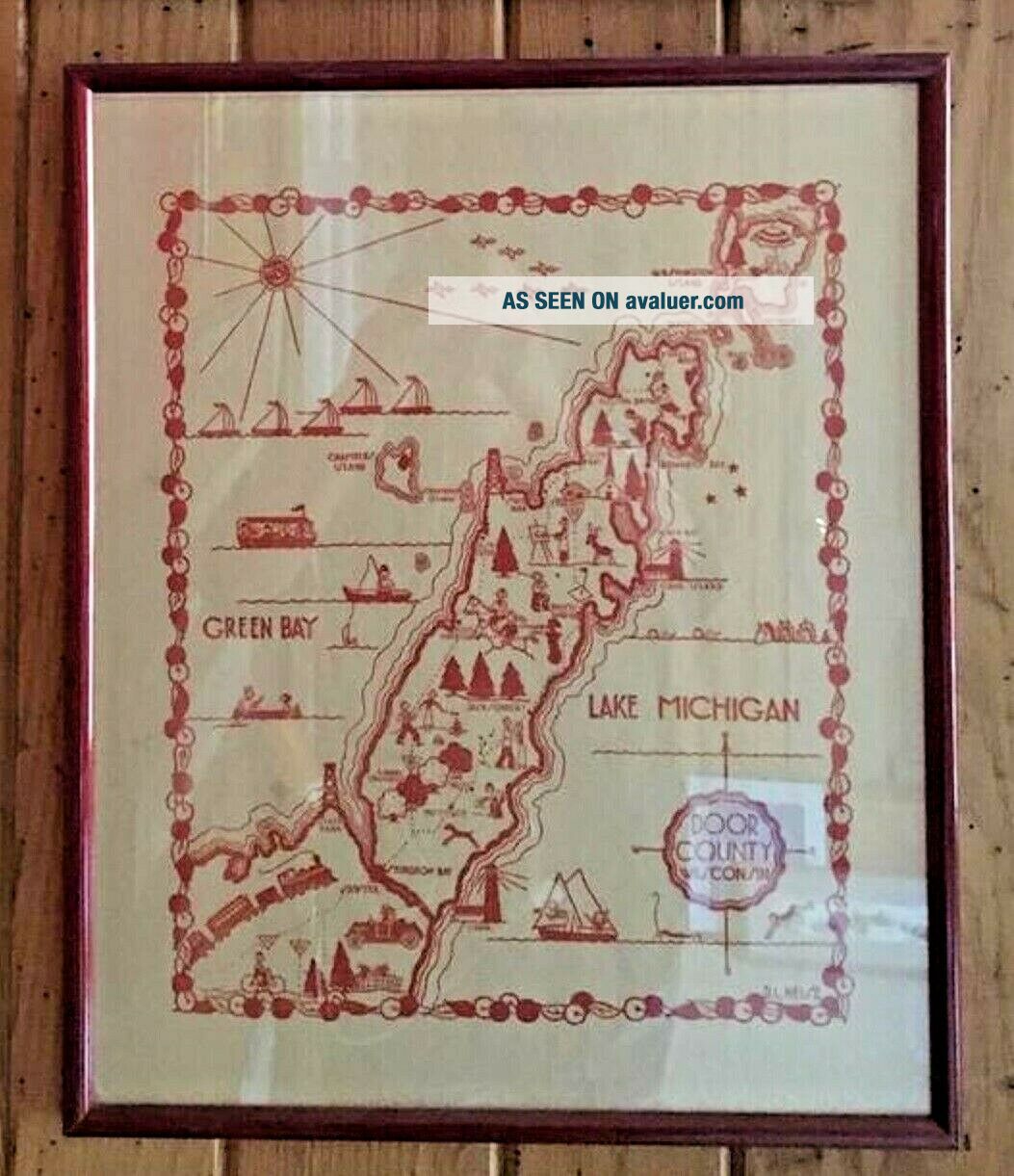
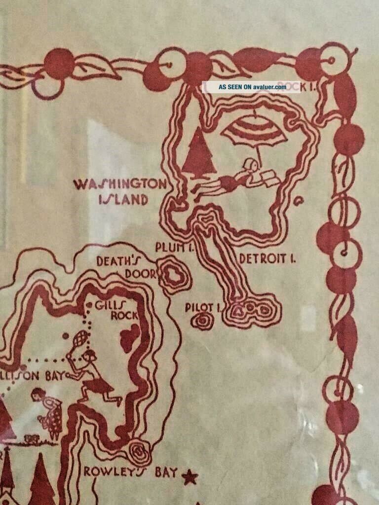
Rare 1940s Wisconsin Tourist Map Door County Green Bay Cartoon D. L. Heise VTG


Item History & Price

Information:
Reference Number: Avaluer:11429Continent: North America
Format: Atlas MapEra: 1940s
Type: County MapPrinting Technique: Lithography
Year: 1940'sOriginal/Reproduction: Original
US State: WisconsinNorth America States & Provinces: Wisconsin
Date Range: 1940-1949Topic: Maps
Country/Region: United States of America
Original Description:
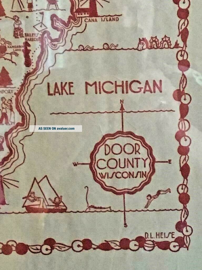
Offering this wonderful 1940s tourist map for Door County Wisconsin. It features lots of whimsical cartoons traipsing around the state. The illustrator's name is given as D. L. Heise in the bottom right corner. I have never seen another example of this map but saw an excerpt of it on a postcard dated 1946. There is minor age-related toning and light creasing with one short vertical tear bottom center, but overall as you can see this is in nice condition and displays wonderfully. Measur...es about 20" x 16 1/2" framed and is ready to hang.


    Similar items


  • Rand - Mcnally City Map: Door County

    Rand - Mcnally City Map: Door County

  • Cats Meow Village Rare Fish Boil Watch Pot Door County Wisconsin Accessory

    Cats Meow Village Rare Fish Boil Watch Pot Door County Wisconsin Accessory

  • Vintage Berkshires Brochure Map Rare 1940’s Tourist

    Vintage Berkshires Brochure Map Rare 1940’s Tourist

  • Green Bay Shore Scene Ellison Bay Wisconsin Rppc Vintage Door County Photo 1946

    Green Bay Shore Scene Ellison Bay Wisconsin Rppc Vintage Door County Photo 1946

  • Rare 1940

    Rare 1940 ' S Bf Goodrich Schwinn Debutante Green Girls Bicycle Bike

  • Rare 1940s Wisconsin Oshkosh People

    Rare 1940s Wisconsin Oshkosh People ' S Wurzer Beer 4 Inch Coaster

  • Postcard,  Wisconsin,  Sister Bay,  Door County,  Nor - Ski Ridge

    Postcard, Wisconsin, Sister Bay, Door County, Nor - Ski Ridge

  • Wisconsin State Map,  Madison,  Milwaukee,  Green Bay,  Badger,  Wi,  Seal - - Postcard

    Wisconsin State Map, Madison, Milwaukee, Green Bay, Badger, Wi, Seal - - Postcard


    • You might also like


    • 1860 Mitchell Hand Colored Map Colorado,  Nebraska & Kansas - Civil War Era

      1860 Mitchell Hand Colored Map Colorado, Nebraska & Kansas - Civil War Era

    • 18th Century French Map Of North America

      18th Century French Map Of North America

    • Las Vegas Nevada Vintage 1967 Us Geological Survey Quadrangle Map 4 Panels

      Las Vegas Nevada Vintage 1967 Us Geological Survey Quadrangle Map 4 Panels

    • Rare Antique 1845 Maps United States Exploring Expedition Book Antartica Hawaii

      Rare Antique 1845 Maps United States Exploring Expedition Book Antartica Hawaii

    • Vintage 1926 Map Hollywood From The Best Surveys Of The Time

      Vintage 1926 Map Hollywood From The Best Surveys Of The Time

    • American Continent (western Hemisphere) 1747 Bowen Antique Copper Engraved Map

      American Continent (western Hemisphere) 1747 Bowen Antique Copper Engraved Map

    • Gulf Coast Florida Texas United States 1705 De Fer Unusual Antique Engraved Map

      Gulf Coast Florida Texas United States 1705 De Fer Unusual Antique Engraved Map

    • California As Island United States 1700 De Fer Unusual First Edition Antique Map

      California As Island United States 1700 De Fer Unusual First Edition Antique Map

Avaluer          About Us          Privacy Policy          Contact Us          UP
© 2022, avaluer.net, Inc. or its affiliates