Statistical Atlas Of The United States 1874 By Francis A. Walker


Item History & Price

Information:
Reference Number: Avaluer:11999
Original Description:
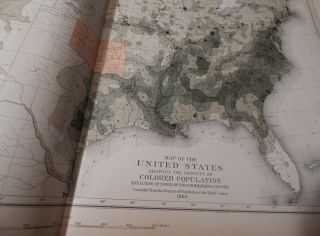
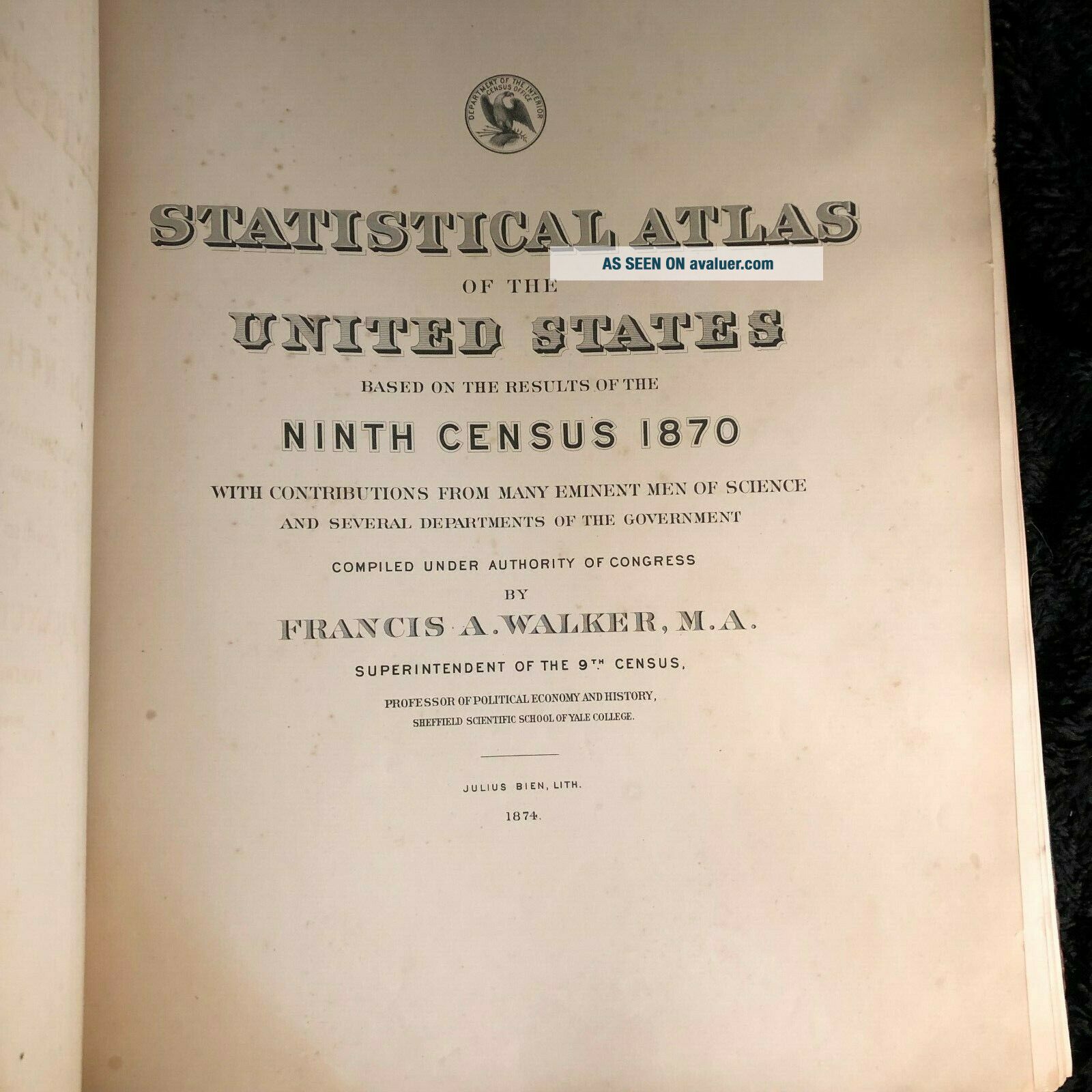
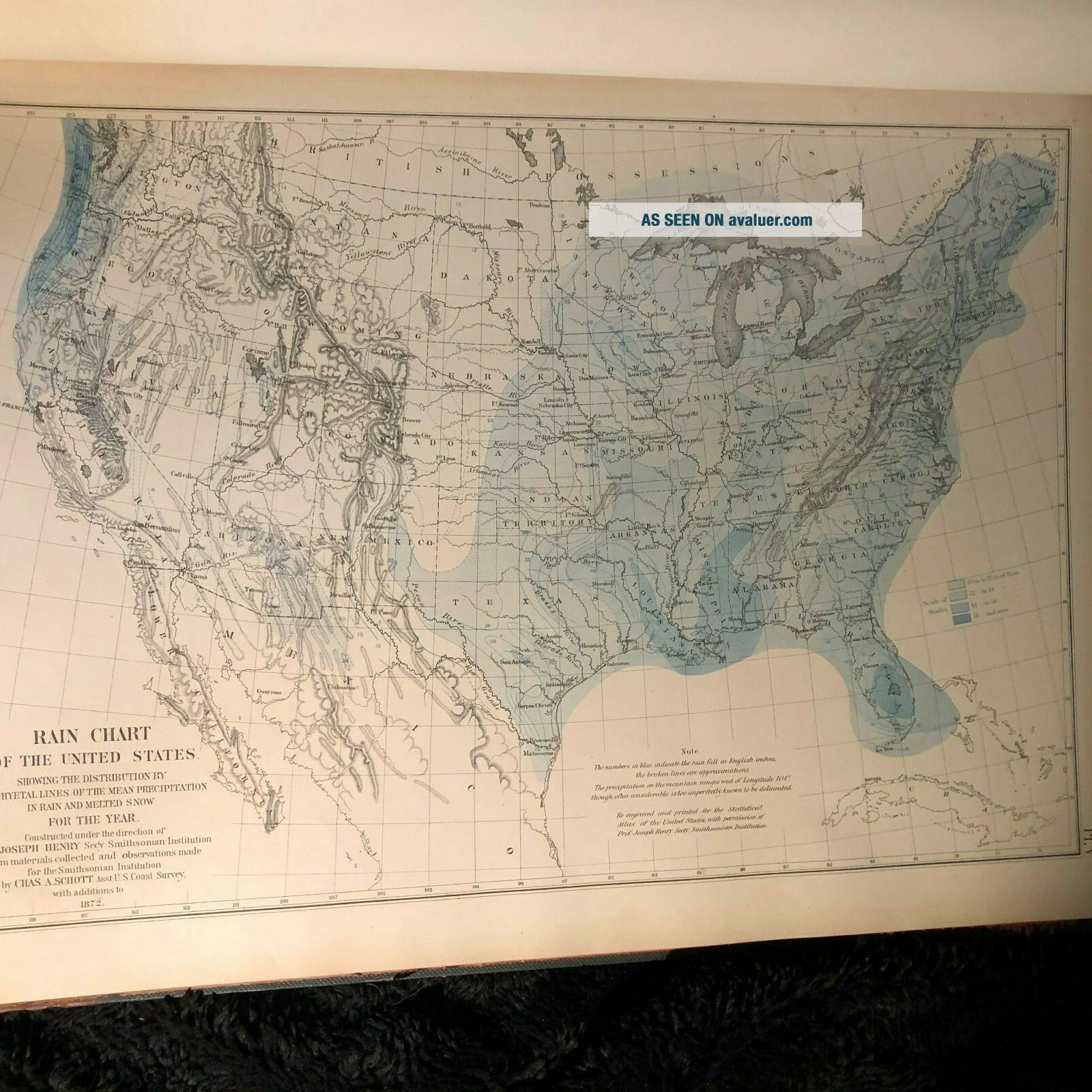
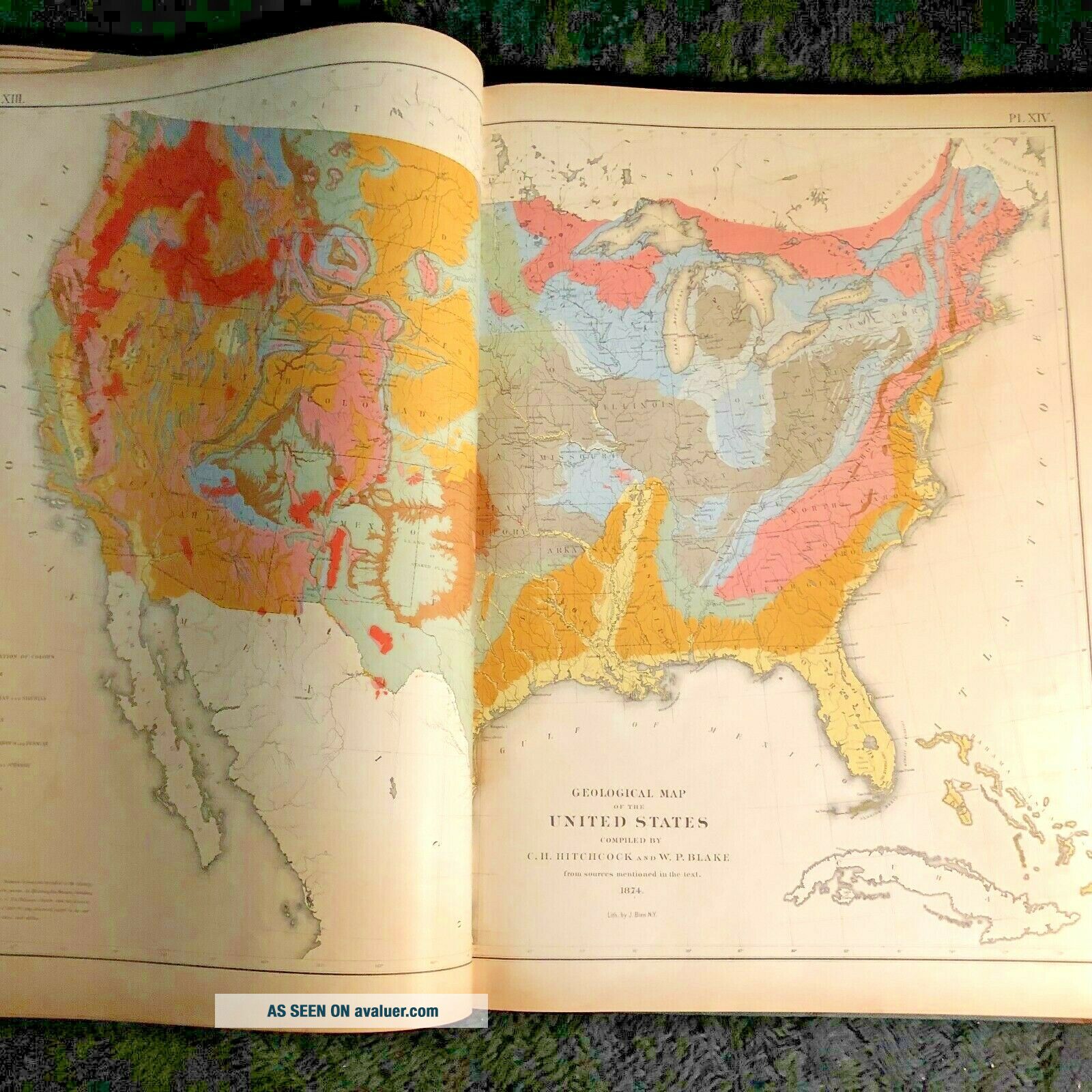
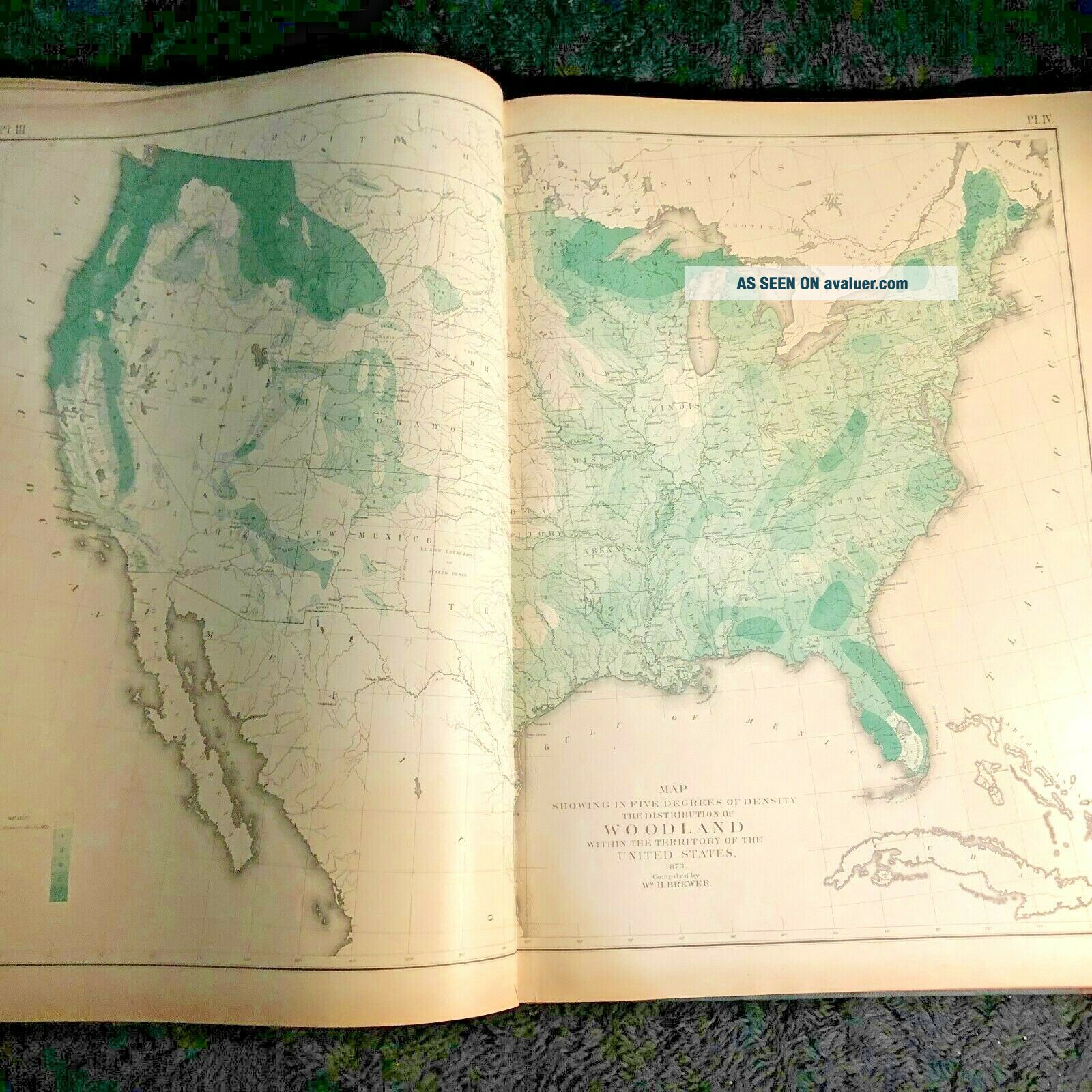
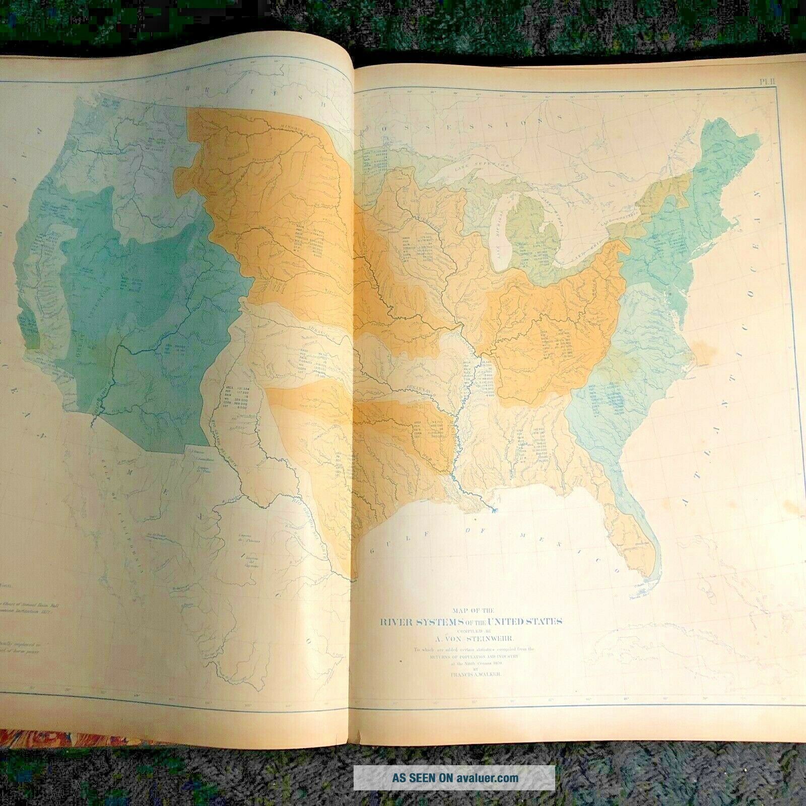
Statistical Atlas of the United States Bases on the Results of the Ninth Census 1870. 1874 by Francis A. Walker Elephant folio, leather spine and tips, gilt title on top cover, illustrated with 54 plates and maps The atlas provides maps and charts on all sorts of statistics from the nine censuses, taken in 1870. This includes occupations of people, race, literacy, population density, political divisions, age and sex, and religious affiliation. Much of this material is il...lustrated in maps and charts.


    Similar items


  • 1973 Rand Mcnally Handy Railroad Atlas Of The United States,  12 " By 9 ",  Book

    1973 Rand Mcnally Handy Railroad Atlas Of The United States, 12 " By 9 ", Book

  • Statistical Atlas Of The United States 1881 - 1880 Dept Of The Interior Us Census

    Statistical Atlas Of The United States 1881 - 1880 Dept Of The Interior Us Census

  • 1948 Handy Railroad Atlas Of The United States; Reprint By Trains Mag,

    1948 Handy Railroad Atlas Of The United States; Reprint By Trains Mag,

  • Centennial History Of The United States 1874 By J.  D.  Mccabe American History

    Centennial History Of The United States 1874 By J. D. Mccabe American History

  • Centennial History Of The United States 1874 By James D.  Mccabe Hardcover Book

    Centennial History Of The United States 1874 By James D. Mccabe Hardcover Book

  • 1928 Handy Railroad Atlas Of The United States By Kalmbach Publishing

    1928 Handy Railroad Atlas Of The United States By Kalmbach Publishing

  • 1853 Book Statistical Gazetteer Of The United States Of America By J.  H.  Colton

    1853 Book Statistical Gazetteer Of The United States Of America By J. H. Colton

  • Rand Mcnally Children

    Rand Mcnally Children ' S Atlas United States Maps Drawings Photographs Vtg 1989


    • You might also like


    • 1860 Mitchell Hand Colored Map Colorado,  Nebraska & Kansas - Civil War Era

      1860 Mitchell Hand Colored Map Colorado, Nebraska & Kansas - Civil War Era

    • 18th Century French Map Of North America

      18th Century French Map Of North America

    • Las Vegas Nevada Vintage 1967 Us Geological Survey Quadrangle Map 4 Panels

      Las Vegas Nevada Vintage 1967 Us Geological Survey Quadrangle Map 4 Panels

    • Rare Antique 1845 Maps United States Exploring Expedition Book Antartica Hawaii

      Rare Antique 1845 Maps United States Exploring Expedition Book Antartica Hawaii

    • Vintage 1926 Map Hollywood From The Best Surveys Of The Time

      Vintage 1926 Map Hollywood From The Best Surveys Of The Time

    • American Continent (western Hemisphere) 1747 Bowen Antique Copper Engraved Map

      American Continent (western Hemisphere) 1747 Bowen Antique Copper Engraved Map

    • Gulf Coast Florida Texas United States 1705 De Fer Unusual Antique Engraved Map

      Gulf Coast Florida Texas United States 1705 De Fer Unusual Antique Engraved Map

    • California As Island United States 1700 De Fer Unusual First Edition Antique Map

      California As Island United States 1700 De Fer Unusual First Edition Antique Map

Avaluer          About Us          Privacy Policy          Contact Us          UP
© 2022, avaluer.net, Inc. or its affiliates