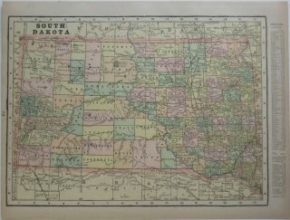
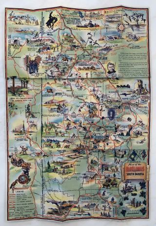
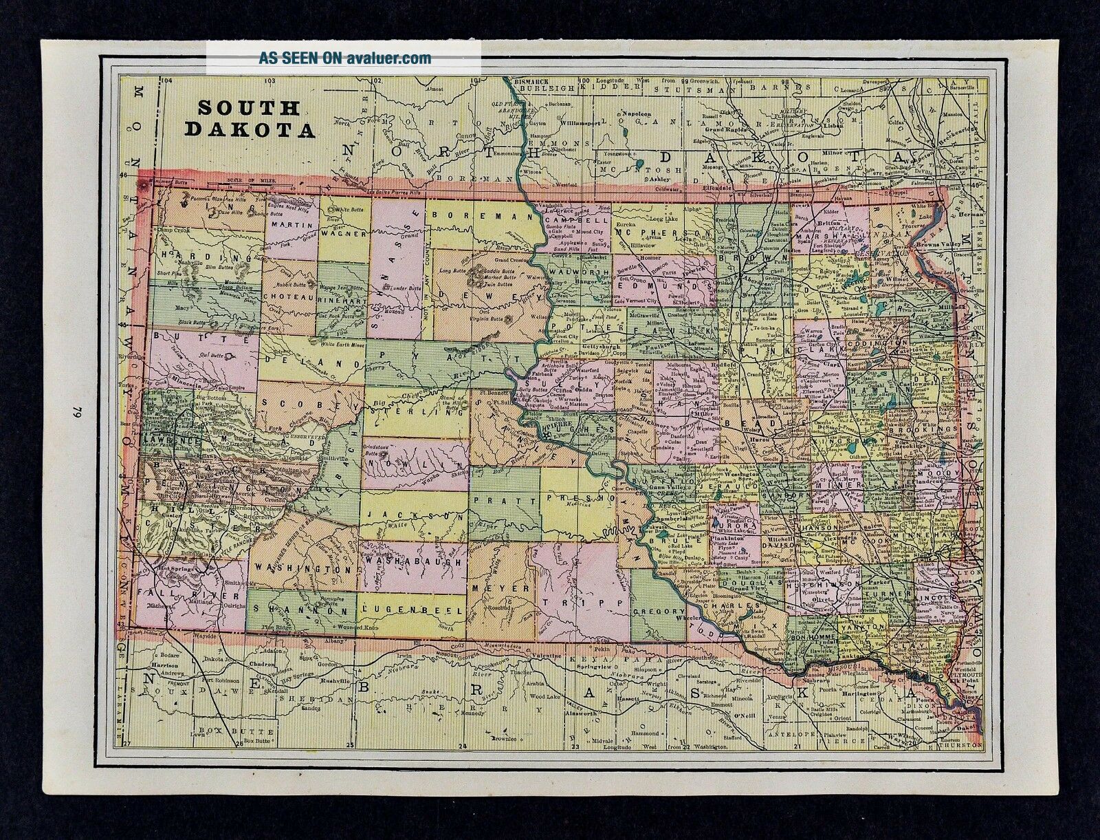
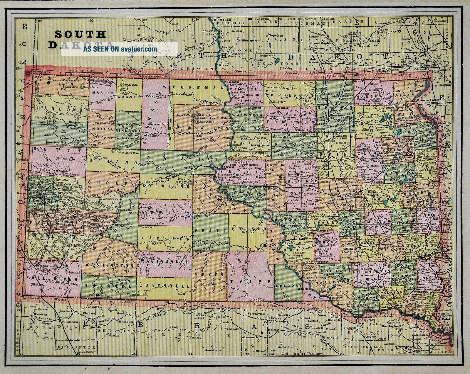
1892 Cram Map - South Dakota Black Hills Deadwood Pierre Sioux Falls Rapid City


Item History & Price

Information:
Reference Number: Avaluer:1231531Topic: Maps
Original Description:
Lake Erie Maps & Prints Ebay Store!An Authentic Antique Map: Not a Modern Reproduction!  See Our Ebay Store for More Antique Maps!Free US Shipping on Purchases of 5 or More Maps and PrintsDescription:  It is an authentic antique map over 100 years old with ceragraphic color.  It is by George F. Cram, 1892. It is not mounted, matted nor framed being sold as a large single sheet as shown in the main pic. There is a partial map on... the reverse.  Overall a beautiful map that would frame up well.Size: The image area measures approximately 10 by 13 inches (25x33cm) on a 11 by 14 1/2" (28x37cm) page.  Condition: The map is in Very Good condition, basically as seen in the pics, very clean with no obvious defects to mention, see the pics for more on condition. The pics are of the actual map.Save on Shipping: We only charge one shipping fee based on the largest map or print with multiple items shipped along with it for no extra costs. Purchase 5 or more maps or prints and receive Free First Class shipping in USA.International Customs and VAT Fees: It is the responsibility of the buyer to pay all Customs Taxes, VAT or other fees that may be due upon arrival. These fees vary greatly from country to country and ebay policy is that the buyer is responsible for their country's taxes and fees. Please consult your country's Customs Regulations for more details on your country, printed matter is duty free in many countries. We declare the full purchase value as required by law. Delays by Customs: Although most items arrive at their destination very quickly, we have no control over how long it takes an item to move through Customs, which can be held for up to six weeks in rare cases.Satisfaction Guaranteed: We stand fully behind our products and offer a full refund minus shipping with no questions asked.Check out my other items!    Be sure to add me to your favorites list!

00105


    Similar items


  • 1961 Standard Oil Company Road Map South Dakota Black Hills Deadwood Rapid City

    1961 Standard Oil Company Road Map South Dakota Black Hills Deadwood Rapid City

  • 1930 Clason Auto Road Map South Dakota Black Hills Rapid City Sioux Falls City

    1930 Clason Auto Road Map South Dakota Black Hills Rapid City Sioux Falls City

  • 1900 Map South Dakota Black Hills Railroads Mines Wounded Knee Custer

    1900 Map South Dakota Black Hills Railroads Mines Wounded Knee Custer

  • 1901 Deadwood South Dakota Black Hills Copper Co.  Underground Mine Workings Map

    1901 Deadwood South Dakota Black Hills Copper Co. Underground Mine Workings Map

  • 22x29 1915 Usgs Topo Map Sturgis,  South Dakota Black Hills National Forest

    22x29 1915 Usgs Topo Map Sturgis, South Dakota Black Hills National Forest

  • 1905 - Geologic Atlas.  Sundance,  Wyoming - South Dakota - Black Hills

    1905 - Geologic Atlas. Sundance, Wyoming - South Dakota - Black Hills

  • 22x29 1915 Usgs Topo Map Spearfish,  South Dakota Black Hills National Forest

    22x29 1915 Usgs Topo Map Spearfish, South Dakota Black Hills National Forest

  • 1940s South Dakota Black Hills Cartoon Map Travel Poster Brochure Vintage Orignl

    1940s South Dakota Black Hills Cartoon Map Travel Poster Brochure Vintage Orignl


    • You might also like


    • 1860 Mitchell Hand Colored Map Colorado,  Nebraska & Kansas - Civil War Era

      1860 Mitchell Hand Colored Map Colorado, Nebraska & Kansas - Civil War Era

    • 18th Century French Map Of North America

      18th Century French Map Of North America

    • Las Vegas Nevada Vintage 1967 Us Geological Survey Quadrangle Map 4 Panels

      Las Vegas Nevada Vintage 1967 Us Geological Survey Quadrangle Map 4 Panels

    • Rare Antique 1845 Maps United States Exploring Expedition Book Antartica Hawaii

      Rare Antique 1845 Maps United States Exploring Expedition Book Antartica Hawaii

    • Vintage 1926 Map Hollywood From The Best Surveys Of The Time

      Vintage 1926 Map Hollywood From The Best Surveys Of The Time

    • American Continent (western Hemisphere) 1747 Bowen Antique Copper Engraved Map

      American Continent (western Hemisphere) 1747 Bowen Antique Copper Engraved Map

    • Gulf Coast Florida Texas United States 1705 De Fer Unusual Antique Engraved Map

      Gulf Coast Florida Texas United States 1705 De Fer Unusual Antique Engraved Map

    • California As Island United States 1700 De Fer Unusual First Edition Antique Map

      California As Island United States 1700 De Fer Unusual First Edition Antique Map

Avaluer          About Us          Privacy Policy          Contact Us          UP
© 2022, avaluer.net, Inc. or its affiliates