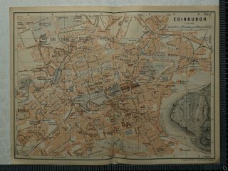
1897 Baedeker Map Plan Of Edinburgh, Scotland


Item History & Price

Information:
Reference Number: Avaluer:1233205Cartographer/Publisher: Karl Baedeker
Original Description:
1897 Baedeker Map Plan of Edinburgh, Scotland

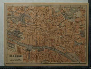
This map plan comes from Karl Baedeker's Handbook for Travellers published in 1897.
Overall page size: 21 cm x 15.5 cm approx. with one fold

Condition: Good imprint
Please study the picture


    Similar items


  • 1910 Vintage Baedeker Map Plan Of Edinburgh,  Scotland

    1910 Vintage Baedeker Map Plan Of Edinburgh, Scotland

  • 1897 Baedeker Map Plan Of Glasgow,  Scotland

    1897 Baedeker Map Plan Of Glasgow, Scotland

  • 1897 Baedeker Map Plan Of Portsmouth,  Gosport & Southsea / Plan Of Chichester Cd

    1897 Baedeker Map Plan Of Portsmouth, Gosport & Southsea / Plan Of Chichester Cd

  • 1897 Baedeker Map Plan Of Bristol,  Map Plan Of Bath,  Plan Of Wells Cathedral

    1897 Baedeker Map Plan Of Bristol, Map Plan Of Bath, Plan Of Wells Cathedral

  • 1897 Baedeker Map Plan Of Brighton

    1897 Baedeker Map Plan Of Brighton

  • 1910 Vintage Baedeker Map Plan Of Glasgow,  Scotland

    1910 Vintage Baedeker Map Plan Of Glasgow, Scotland

  • 1897 Baedeker Map Plan Of Oxford

    1897 Baedeker Map Plan Of Oxford

  • 1897 Baedeker Map Plan Of Liverpool

    1897 Baedeker Map Plan Of Liverpool


    • You might also like


    • Hungary & Romania 1579 (1584) Ortelius Unusual Antique Copper Engraved Map

      Hungary & Romania 1579 (1584) Ortelius Unusual Antique Copper Engraved Map

    • Brussels Bruxelles Belfium 1777 De Ferraris & Dupuis Large Antique Map Sheet Xxi

      Brussels Bruxelles Belfium 1777 De Ferraris & Dupuis Large Antique Map Sheet Xxi

    • 1616 Atlas Map Of Iceland.

      1616 Atlas Map Of Iceland.

    • Kazan Russia 1767 Le Clerc/lespinasse Antique Copper Engraved City View

      Kazan Russia 1767 Le Clerc/lespinasse Antique Copper Engraved City View

    • 1899 Stanford,  Folding Map Of Norwich,  Norfolk,  Arthur Collins,  Jarrold & Sons,

      1899 Stanford, Folding Map Of Norwich, Norfolk, Arthur Collins, Jarrold & Sons,

    • 1948 Vintage Linen Colour Map Geological Survey Ten Mile Of Great Britain

      1948 Vintage Linen Colour Map Geological Survey Ten Mile Of Great Britain

    • 1944 Map Flying Bombs Sussex Ww2 Newspaper Military Kent Courier German V1 V2

      1944 Map Flying Bombs Sussex Ww2 Newspaper Military Kent Courier German V1 V2

    • Dated 1638 Vellum Map Of Icklesham Sussex Showing Land Uses Owners Etc

      Dated 1638 Vellum Map Of Icklesham Sussex Showing Land Uses Owners Etc

Avaluer          About Us          Privacy Policy          Contact Us          UP
© 2022, avaluer.net, Inc. or its affiliates