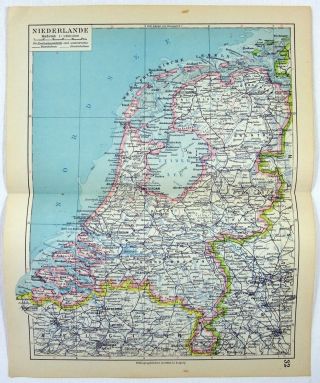
1878 Map Of The Netherlands By William Hughes & John Dower. HollAntique


Item History & Price
Original 1878 Map of the Netherlands by William Hughes & John Dower - A finely detailed Color Lithograph that shows the countries Provinces, Cities, Major Towns, Mountains, Lakes, Rivers, Railroads & Harbors. From the 1878 edition of the Modern Atlas of the Earth. Measures approximately 13" by 10" with a blank reverse. Will look great matted and framed.
Free Shipping to anywhere in the US.
Your order will always ship within ONE BUSINESS DAY, well packaged in a s...turdy waterproof mailer and sent with a delivery confirmation.
I ship worldwide.
Free Shipping to anywhere in the US.
Your order will always ship within ONE BUSINESS DAY, well packaged in a s...turdy waterproof mailer and sent with a delivery confirmation.
I ship worldwide.