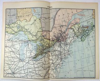
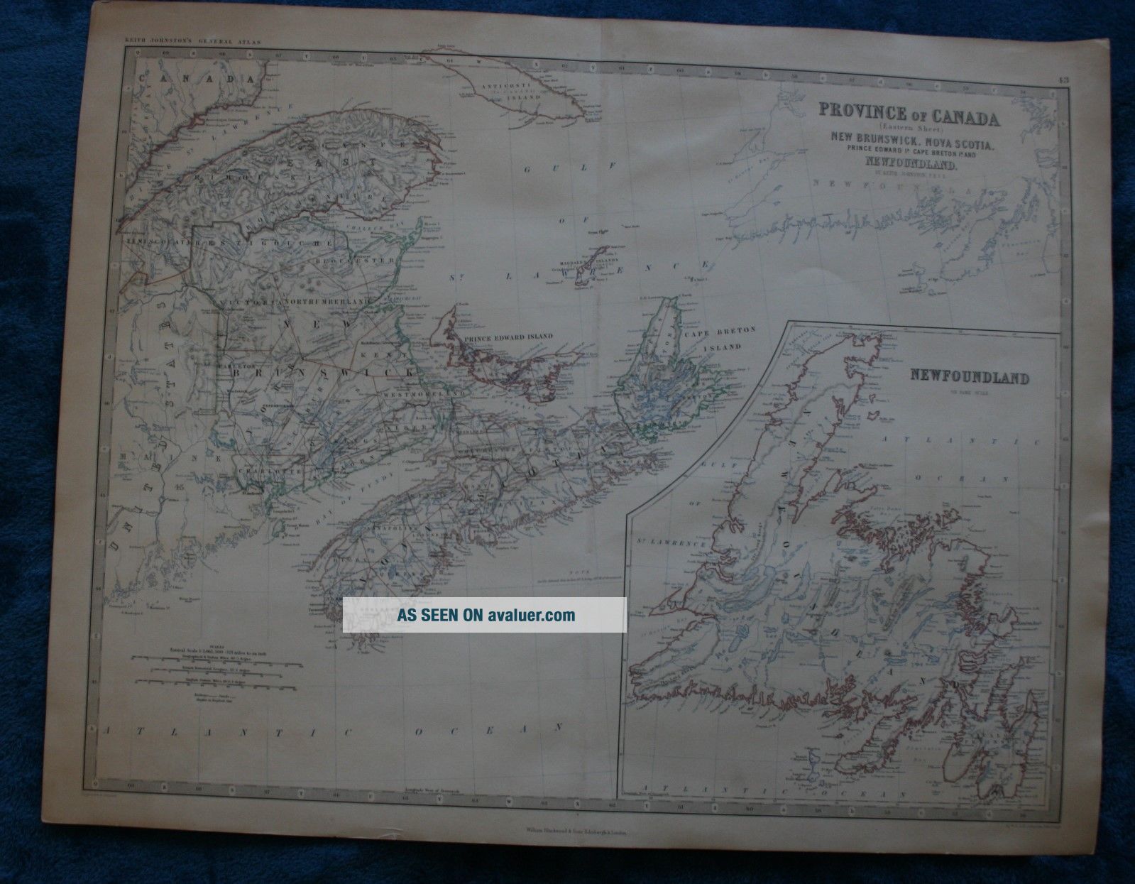
Large Antique Map Of Eastern Canada N. B. , P. E. I, N. S. Nfld. Published 1861


Item History & Price

Information:
Reference Number: Avaluer:1238230Cartographer/Publisher: Keith Johnston
Type: World AtlasPrinting Technique: steel engraving
Year: 1861Original/Reproduction: Antique Original
Date Range: 1800-1899Canadian Province: New Brunswick, Newfoundland & Labrador, Nova Scotia, Prince Edward Island
Country/Region: CanadaFormat: Folding Map
Original Description:
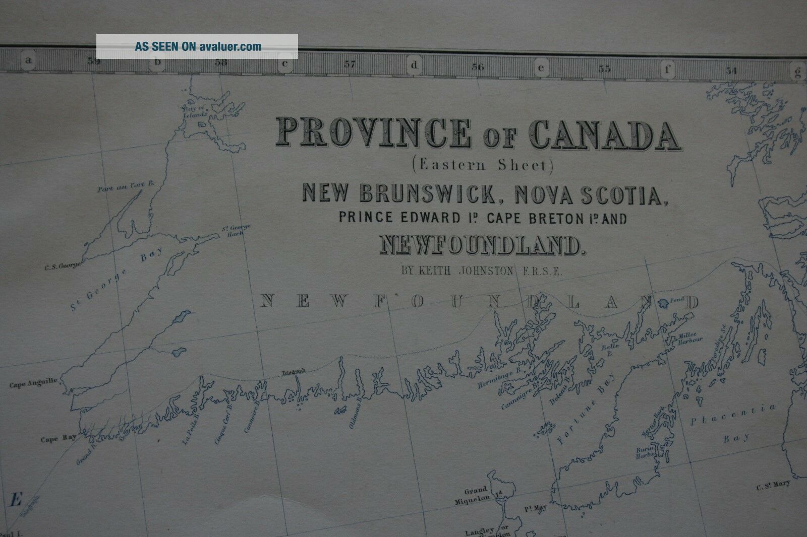
Provinceof CanadaNewBrunswick, Nova Scotia, PrinceEdward Island, CapeBreton andNewfoundland
published1861
Steel-engravedmap with original colouring, from 'Keith Johnston's General Atlas' of1892. W. & A.K. Johnston was a major geographical publishinghouse, co-founded by the brothers William (1802-1888) and AlexanderKeith (1804-1871).
mapmeasures 44 cm x 57 cmReadyfor Framing


    Similar items


  • 1892 Railroad Map Of Eastern Canada.  Antique

    1892 Railroad Map Of Eastern Canada. Antique

  • 1720 John Senex Large Antique Map Of Africa - Dedicated To Isaac Newton

    1720 John Senex Large Antique Map Of Africa - Dedicated To Isaac Newton

  • 1642 Joan Blaeu Large Antique Map Of Ireland - Hibernia Regnum

    1642 Joan Blaeu Large Antique Map Of Ireland - Hibernia Regnum

  • 1842 Large,  Antique Map Of Palestine By W.  Hughes (william Hughes Mapmaker)

    1842 Large, Antique Map Of Palestine By W. Hughes (william Hughes Mapmaker)

  • 1784 Du Bocage Large Antique Map Of Thermopylae Pass,  Greece

    1784 Du Bocage Large Antique Map Of Thermopylae Pass, Greece

  • Large Antique Map Of Tennessee 1911 Rand - Mcnally Atlas

    Large Antique Map Of Tennessee 1911 Rand - Mcnally Atlas

  • Large Antique Map Of Philadelphia From 1911 Rand - Mcnally Atlas 28.  25 X 20.  5

    Large Antique Map Of Philadelphia From 1911 Rand - Mcnally Atlas 28. 25 X 20. 5

  • Large Antique Map Of Ohio From 1911 Rand - Mcnally Atlas 28.  25 X 20.  5

    Large Antique Map Of Ohio From 1911 Rand - Mcnally Atlas 28. 25 X 20. 5


    • You might also like


    • 1860 Mitchell Hand Colored Map Colorado,  Nebraska & Kansas - Civil War Era

      1860 Mitchell Hand Colored Map Colorado, Nebraska & Kansas - Civil War Era

    • 18th Century French Map Of North America

      18th Century French Map Of North America

    • Las Vegas Nevada Vintage 1967 Us Geological Survey Quadrangle Map 4 Panels

      Las Vegas Nevada Vintage 1967 Us Geological Survey Quadrangle Map 4 Panels

    • Rare Antique 1845 Maps United States Exploring Expedition Book Antartica Hawaii

      Rare Antique 1845 Maps United States Exploring Expedition Book Antartica Hawaii

    • Vintage 1926 Map Hollywood From The Best Surveys Of The Time

      Vintage 1926 Map Hollywood From The Best Surveys Of The Time

    • American Continent (western Hemisphere) 1747 Bowen Antique Copper Engraved Map

      American Continent (western Hemisphere) 1747 Bowen Antique Copper Engraved Map

    • Gulf Coast Florida Texas United States 1705 De Fer Unusual Antique Engraved Map

      Gulf Coast Florida Texas United States 1705 De Fer Unusual Antique Engraved Map

    • California As Island United States 1700 De Fer Unusual First Edition Antique Map

      California As Island United States 1700 De Fer Unusual First Edition Antique Map

Avaluer          About Us          Privacy Policy          Contact Us          UP
© 2022, avaluer.net, Inc. or its affiliates