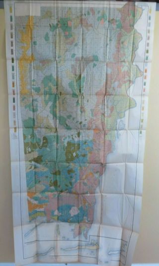
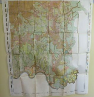
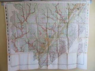
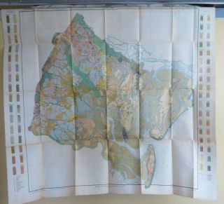
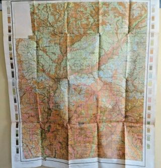
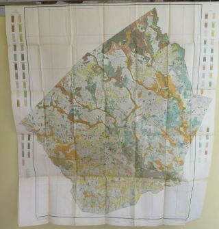
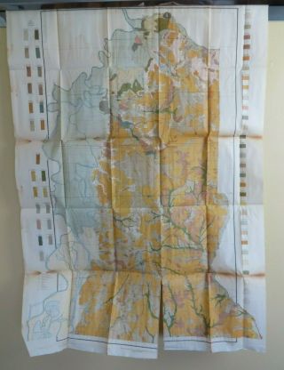
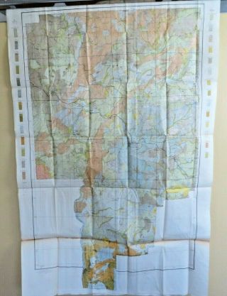
1911 Antique Color Map Elmore County Alabama Titus Tallassee 27X29 0473


Item History & Price

Information:
Reference Number: Avaluer:1243933Topic: Antiques
Format: Sheet MapPublication Year: 1911
Type: USDA Soil Survey MapCartographer/Publisher: USDA
Year: 1911Original/Reproduction: Original
US State: AlabamaMaker: US Dept of Agriculture
Date Range: 1910-1919Features: Antique
Country/Region: United States of America
Original Description:
ANTIQUE MAPUS Department of Agriculture Bureau of SoilsOriginal Soil Map dated 1911Suitable for framingMeasures approximately 37.5" wide 29.5" height including marginsFolded measures approximately 9" X 6"Elmore County, Alabama  Includes:WetumpkaTitusDeatsvilleMillbrookTallasseeButts MillEclecticHornsbytown...and vicinityShips in a rigid photo mailerFolded map is over 100 years old - Paper shows yellowing/foxing consistent with age, has some creases/fold lines, pin holes ...and/or tears.  Soiling from years of storage.  Some edge or margin tears possible. NOTE:  Open unfold your map with care, paper is over 100 years old.


    Similar items


  • 1911 Antique Color Map Mobile County Alabama Gulfcrest Dauphin Is.  32x63 0477

    1911 Antique Color Map Mobile County Alabama Gulfcrest Dauphin Is. 32x63 0477

  • 1911 Antique Color Map Madison County Alabama Huntsville Harvest 33x39 0475

    1911 Antique Color Map Madison County Alabama Huntsville Harvest 33x39 0475

  • 1911 Antique Color Map Jackson County Alabama Scottsboro Bridgeport 45x38 0474

    1911 Antique Color Map Jackson County Alabama Scottsboro Bridgeport 45x38 0474

  • 1911 Antique Color Map Glynn County Georgia Brunswick Jekyll Island 35x32 0470

    1911 Antique Color Map Glynn County Georgia Brunswick Jekyll Island 35x32 0470

  • 1909 Antique Color Map Coffee County Alabama Enterprise Richburg 27 X 32 0373

    1909 Antique Color Map Coffee County Alabama Enterprise Richburg 27 X 32 0373

  • 1911 Antique Color Map Johnston County North Carolina Clayton Selma 37x42 0466

    1911 Antique Color Map Johnston County North Carolina Clayton Selma 37x42 0466

  • 1909 Antique Color Map Baldwin County Alabama Stockton Morriston 28 X 40 0370

    1909 Antique Color Map Baldwin County Alabama Stockton Morriston 28 X 40 0370

  • 1909 Antique Color Map Tallapoosa County Alabama Alexander City 29 X 44 0368

    1909 Antique Color Map Tallapoosa County Alabama Alexander City 29 X 44 0368


    • You might also like


    • 1860 Mitchell Hand Colored Map Colorado,  Nebraska & Kansas - Civil War Era

      1860 Mitchell Hand Colored Map Colorado, Nebraska & Kansas - Civil War Era

    • 18th Century French Map Of North America

      18th Century French Map Of North America

    • Las Vegas Nevada Vintage 1967 Us Geological Survey Quadrangle Map 4 Panels

      Las Vegas Nevada Vintage 1967 Us Geological Survey Quadrangle Map 4 Panels

    • Rare Antique 1845 Maps United States Exploring Expedition Book Antartica Hawaii

      Rare Antique 1845 Maps United States Exploring Expedition Book Antartica Hawaii

    • Vintage 1926 Map Hollywood From The Best Surveys Of The Time

      Vintage 1926 Map Hollywood From The Best Surveys Of The Time

    • American Continent (western Hemisphere) 1747 Bowen Antique Copper Engraved Map

      American Continent (western Hemisphere) 1747 Bowen Antique Copper Engraved Map

    • Gulf Coast Florida Texas United States 1705 De Fer Unusual Antique Engraved Map

      Gulf Coast Florida Texas United States 1705 De Fer Unusual Antique Engraved Map

    • California As Island United States 1700 De Fer Unusual First Edition Antique Map

      California As Island United States 1700 De Fer Unusual First Edition Antique Map

Avaluer          About Us          Privacy Policy          Contact Us          UP
© 2022, avaluer.net, Inc. or its affiliates