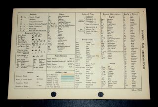
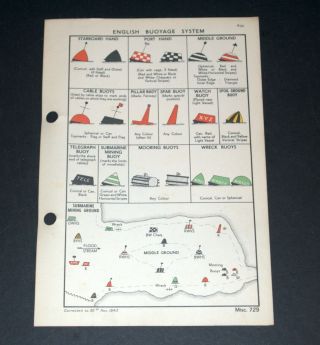
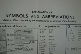
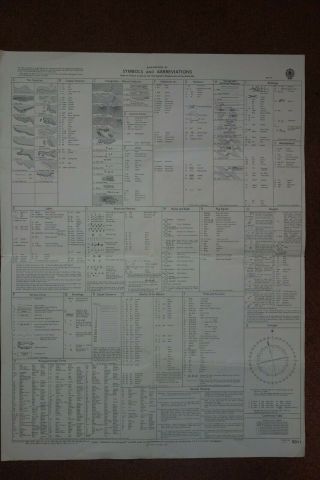
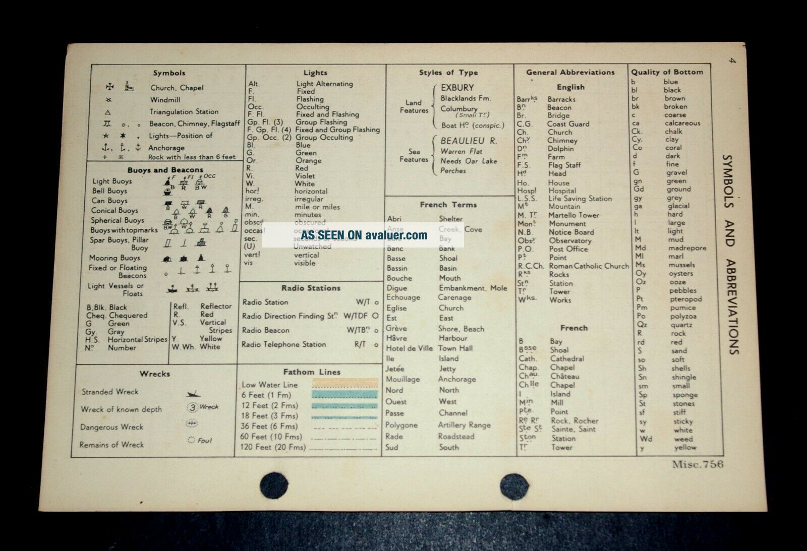
Vintage WW2 Map SYMBOLS AND ABBREVIATIONS English/French 1943


Item History & Price

Information:
Reference Number: Avaluer:1245272Cartographer/Publisher: Admiralty
Year: 1943Original/Reproduction: Vintage Original
Country/Region: EnglandFormat: Sheet Map
Era: 1940sType: Nautical Map
Original Description:
Vintage Naval WW2 Map SYMBOLS AND ABBREVIATIONS, English & French 1943Published by the Hydrographic Department of the Admiralty, for a Naval Handbook.  OriginallyRESTRICTED but now declassified.In good condition showing amazing detail.Printed on fine card.  Overall size 9.5(w) x 9.6(h) ins.  Suitable for framing.Thisis a genuine map and not a copy, facsimile or computer generated image.Please see my other auctions/sales for similar.   PA...YPAL only.  UK P&P £1.30.  Combined postage available.
    

00121


    Similar items


  • - Vintage Ww2 Map Symbols And Abbreviations English/french 1943

    - Vintage Ww2 Map Symbols And Abbreviations English/french 1943

  • - Vintage Ww2 Map Symbols Of French Buoys & Beacons 1943

    - Vintage Ww2 Map Symbols Of French Buoys & Beacons 1943

  • Rare Vintage Ww2 Map Symbols Of French Buoys & Beacons 1943

    Rare Vintage Ww2 Map Symbols Of French Buoys & Beacons 1943

  • Rare Vintage Ww2 Map Symbols Of English Buoyage System 1943

    Rare Vintage Ww2 Map Symbols Of English Buoyage System 1943

  • - Rare Vintage Ww2 Map Symbols Of French Buoys & Beacons 1943

    - Rare Vintage Ww2 Map Symbols Of French Buoys & Beacons 1943

  • A 1954 Vintage Admiralty Naval Chart No 5011,

    A 1954 Vintage Admiralty Naval Chart No 5011, ' Symbols And Abbreviations '

  • A 1954 Vintage Admiralty Naval Chart No 5011,

    A 1954 Vintage Admiralty Naval Chart No 5011, ' Symbols And Abbreviations '

  • Lorus Vintage Men

    Lorus Vintage Men ' S Watch Vj33 - X001 Silver Tone, Day And Date English/french


    • You might also like


    • Hungary & Romania 1579 (1584) Ortelius Unusual Antique Copper Engraved Map

      Hungary & Romania 1579 (1584) Ortelius Unusual Antique Copper Engraved Map

    • Brussels Bruxelles Belfium 1777 De Ferraris & Dupuis Large Antique Map Sheet Xxi

      Brussels Bruxelles Belfium 1777 De Ferraris & Dupuis Large Antique Map Sheet Xxi

    • 1616 Atlas Map Of Iceland.

      1616 Atlas Map Of Iceland.

    • Kazan Russia 1767 Le Clerc/lespinasse Antique Copper Engraved City View

      Kazan Russia 1767 Le Clerc/lespinasse Antique Copper Engraved City View

    • 1899 Stanford,  Folding Map Of Norwich,  Norfolk,  Arthur Collins,  Jarrold & Sons,

      1899 Stanford, Folding Map Of Norwich, Norfolk, Arthur Collins, Jarrold & Sons,

    • 1948 Vintage Linen Colour Map Geological Survey Ten Mile Of Great Britain

      1948 Vintage Linen Colour Map Geological Survey Ten Mile Of Great Britain

    • 1944 Map Flying Bombs Sussex Ww2 Newspaper Military Kent Courier German V1 V2

      1944 Map Flying Bombs Sussex Ww2 Newspaper Military Kent Courier German V1 V2

    • Dated 1638 Vellum Map Of Icklesham Sussex Showing Land Uses Owners Etc

      Dated 1638 Vellum Map Of Icklesham Sussex Showing Land Uses Owners Etc

Avaluer          About Us          Privacy Policy          Contact Us          UP
© 2022, avaluer.net, Inc. or its affiliates