1922 Natchez Mississippi Louisiana Vidalia Vintage 15 - Minute USGS Topo Map
Item History & Price
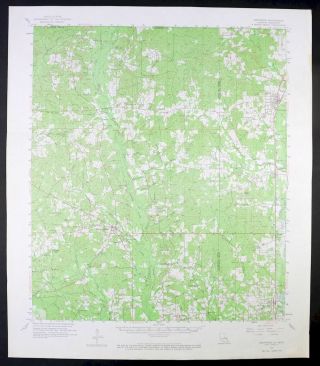
1922 NATCHEZ MISSISSIPPI USGS TOPO MAP Vintage Cartographics Mississippi Maps ∙ Antique Prints ∙ Bargain Bin ∙ Browse Nearby Sheets 1922
Natchez
Mississippi-Louisiana
USGS TOPOGRAPHIC MAP
1938 print in very good condition
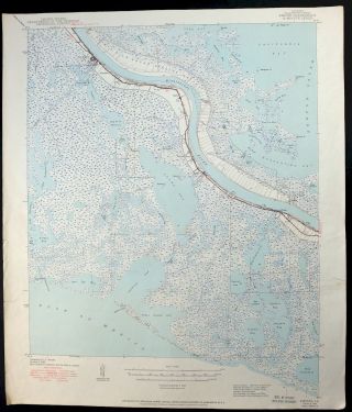
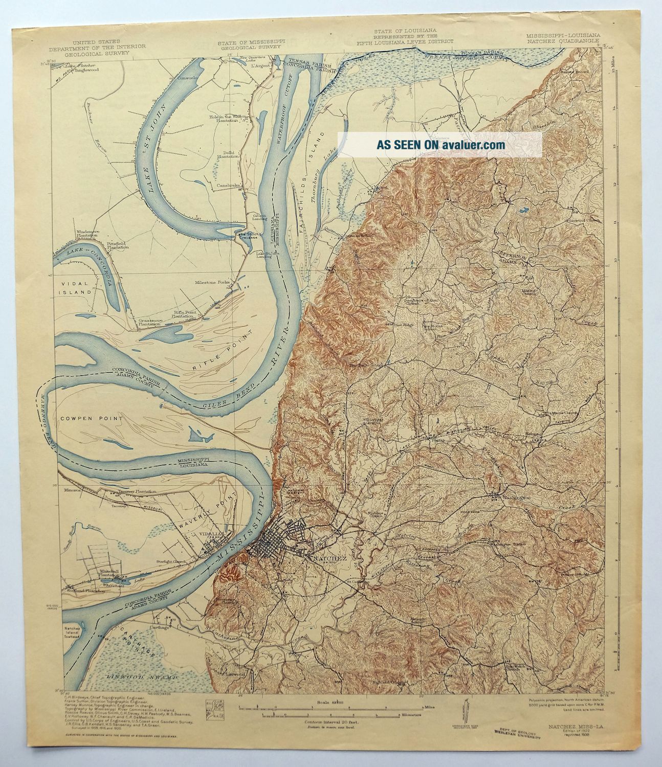
For sale is the 1922 edition of the Natchez 15-minute map. This map would be ideal for framing or display, historica...l reference or research, genealogy studies, adding to your collection, treasure hunting, a nice conversation piece, a gift for a history or map enthusiast, or for anyone interested in this area. This sheet includes the first survey done by the United States Geological Survey for the Natchez 15-minute quadrangle. The map sheet is an original 1938 USGS print in very good condition. The Natchez 15-minute map shows all roads, paths, towns, railroads, rivers, creeks, elevation contour lines, public land survey lines, county, state, and other administrative boundaries as they existed at the time of the survey in 1909 through 1920. All known structures (houses, churches, schools, barns, cabins, etc) are also shown, with exceptions in some urban areas, where only landmark buildings may be shown. The Natchez map was surveyed before aerial photography methods were widely used in map data gathering. It was drawn by Geological Survey cartographers based on plane table field survey information as well as information gathered from local residents in the area. It displays the remarkable abilities of the early USGS map makers, who placed a strong emphasis on creating complete, accurate, and cartographically appealing maps. Maps from the 15-minute series for the continental United States are no longer produced or printed by the USGS and original prints are becoming increasingly difficult to find. They are a valuable historical record for an area, as they contain many placenames and features that have been dropped from more recent maps. MAP DETAILS Title Natchez State Mississippi-Louisiana Series 15-minute Surveyed 1909 through 1920 Field Survey Geographer C.H. Birdseye Edition 1922 Printed 1938 Scale 1:62500 Contour Interval 20 Foot Sheet Dimensions 16 1/2 x 20 inches (approximate) Map Dimensions 14 7/8 x 17 1/2 inches Coverage Area Roughly 14 x 16 miles SHEET CONDITION For maps of this vintage, effort is made to note all visible flaws, no matter how minor. Overall Condition VERY GOOD Sheet Notes lightly handled, never folded Map Area no wear, no markings, no blemishes, flawless map area Collar Area minor edge wear or tears, no markings, very minor blemishes, has inventory/library stamp MAP COVERAGE Quadrangle extent overlaid on current basemap. Browse Nearby
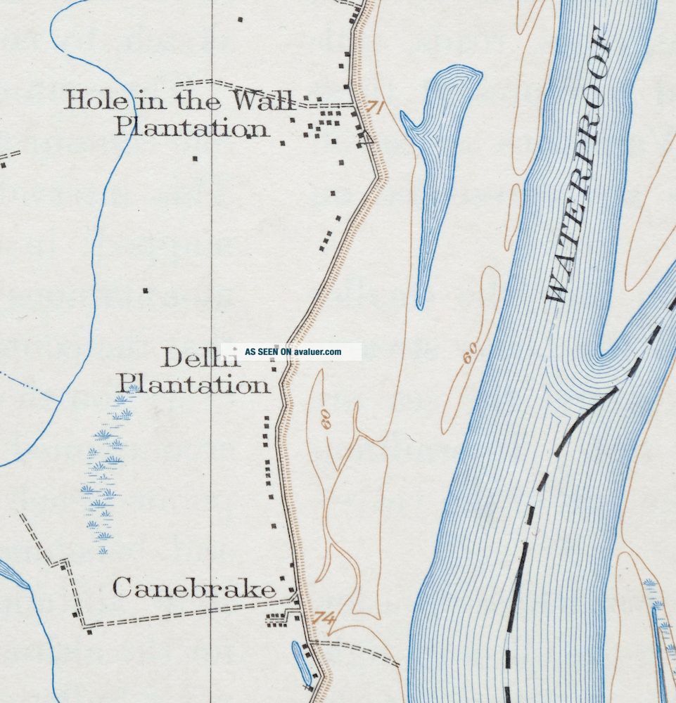
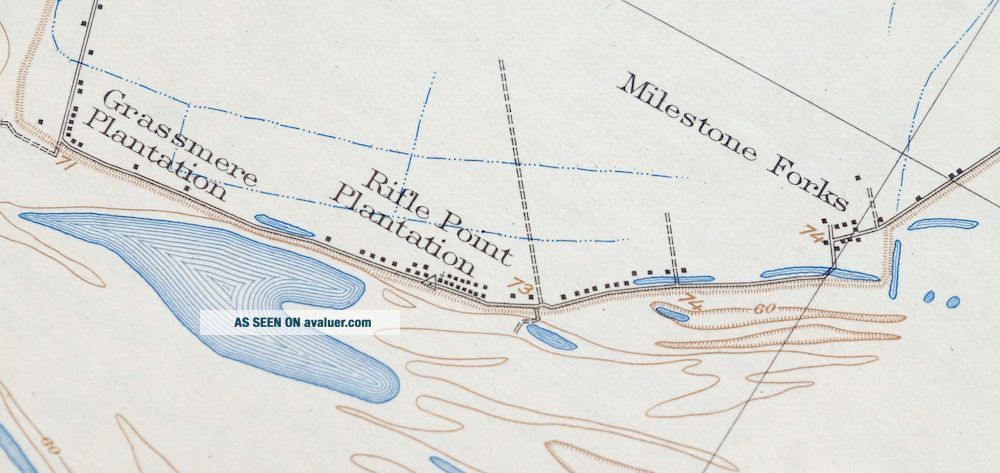
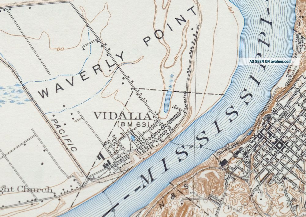
Sheets PLACENAMES Depending on map series and survey date, all of the features listed below may not be shown on this map. This list contains features that currently exist or historically existed within the area covered by this map. The list can be used as a reference to determine if this map covers your area of interest. Placenames are listed alphabetically next to each feature type. Cities and Towns (current) Natchez and Vidalia Counties Covered Adams, Concordia, Jefferson, and Tensas Federal Land Units Saint Catherine Creek National Wildlife Refuge Rivers and Streams Blueskin Creek, Cemetery Bayou, Coles Creek, Dunbar Bayou, Fairchilds Creek, Hardings Bayou, Kittering Creek, Languedoc Creek, Mammoth Bayou, Melvin Bayou, Mississippi River, Pearl Bayou, Perkins Creek, Pine Mount Bayou, Rules Branch, Saint Catherine Creek, Sandy Bayou, Sandy Branch, Second Creek, Spanish Bayou, Wades Bayou, and Zurhellen Bayou Water Bodies Big Blue Hole, Big Lagoon, Brandenburg Pit, Lake Concordia, Cypress Lake, Duck Pond, Fields Lake, Flat Lake, Fletchers Lake, Grassy Lake, Junkins Lake, Lake Concordia, Lake Saint John, Marengo Lake, Mud Lake, New Quarters Lake, Lake Saint John, Thornburg Lake, and Whitehall Lake IN MISSISSIPPI Populated Places: Anna, Carthage, Hawthorne, Foster, Johnsville, Linwood, Morgantown, Natchez, Pine Ridge, Saint Catherine, Selma, and Washington. Post Offices: Natchez Post Office. Locations: Carthage Landing, Cowpen Point Landing, Giles Landing, Liberty Shopping Center, Magnolia Mall Shopping Center, Natchez Country Club, Natchez-Adams County Port, Parker Landing, Trace Town Shopping Center, and Waverly Place Landing. Administrative Boundaries: District 1 Supervisor District, District 2 Supervisor District, District 3 Supervisor District, District 4 Supervisor District, and District 5 Supervisor District. Mountains, Peaks, and Summits: Fatherland Mounds and Foster Mounds. Parks: Natchez National Historical Park. Drainages: Bisland Bayou, Blueskin Creek, Bullhead Bayou, Cemetery Bayou, Hardings Bayou, Coles Creek, Dunbar Bayou, Fairchilds Creek, Greens Bayou, Kittering Creek, Languedoc Creek, Mammoth Bayou, Melvin Bayou, Pearl Bayou, Perkins Creek, Pine Mount Bayou, Quitman Bayou, Rules Branch, Saint Catherine Creek, Sandy Bayou, Sandy Branch, Saragossa Bayou, Spanish Bayou, Wades Bayou, and Zurhellen Bayou. Islands: Fairchilds Island Number 114 and Mercer Island. Capes: Carthage Point and Cowpen Point. Churches: Antioch Church, Assumption Church, Bethel Church, Beulah Baptist Church, Briel Avenue Baptist Church, China Grove Baptist Church, Church of Christ, Clermont Church, Clover Hill Church, Community Chapel Church of God, Daughters of Zion Church, Ebenezer Baptist Church, Faith Tabernacle Church, Fatherland Church, First Baptist Church, First Church of the Nazarene, First Presbyterian Church, Forest Aid Church, Friendship Church, Grace United Methodist Church, Greater Fatherland Baptist Church, Greater Mount Sinai Baptist Church, Greater New Bethlehem Baptist Church, Greater New Zion Baptist Church, Holy Family Catholic Church, Immanuel Baptist Church, Jefferson Street United Methodist Church, Jerusalem Baptist Church, King Solomon Baptist Church, Linwood Church, Macedonia Baptist Church, Marble Stone Church, Milford Church, Morgantown Baptist Church, Morning Pilgrim Church, Mount Bruin Church, Mount Nebo Baptist Church, Mount Pilgrim Church, Murrays Temple Church of God, New Zion Baptist Church, Parkway Baptist Church, Pentecostal Church of God in Christ, Pilgrim Church, Pine Mount Church, Pine Ridge Presbyterian Church, Pleasant Green Baptist Church, Providence Church, Riverside Church, Rose Hill Baptist Church, Saint Johns Church, Saint Marys Cathedral, Saint Marys Church, Saint Peters Baptist Church, Salem Church, Second Union Church, Shiloh Baptist Church, Smithland Church, Southern Hills Baptist Church, Springfield Church, Tabernacle of Prayer Church, Trace City Baptist Church, Trinity Episcopal Church, United Baptist Church, Washington Baptist Church, Washington United Methodist Church, West Side Baptist Church, Wilderness Church, Zion Chapel African Methodist Episcopal Church, Zion Hill Church, and Zion Watch Church. Hospitals: Charity Hospital, Humana Hospital of Natchez, and Jefferson Davis Memorial Hospital. Lakes and Ponds: Blue Hole, Duck Pond, Fields Lake, Flat Lake, Junkins Lake, Marengo Lake, Otter Lake, Pumpkin Lake, and Thornburg Lake. Channels: Giles Cutoff and Water Proof Cutoff. Dams: Callon Lake Dam, Carl Anderson Lake Dam, Frank Junkin Lake Dam, Junkin Gravel Company Lake Dam, Kaiser-Carlton Lake Dam, Risher Lake Dam, Second Creek Watershed Structure 6a Dam, and Tully Seale Lake Dam. Buildings: Adams County Courthouse. Bridges: Natchez-Vidalia Bridge. Bends: Fairchilds Bend, Giles Bend, and Marengo Bend. Bars: Carthage Upper Bar and Natchez Island Bar. Towers: WMIS-AM (Natchez), WNAT-AM (Natchez), and WQNZ-FM (Natchez). Levees: Carthage Revetment and Natchez Front Revetment. Oilfields: Anna Oil Field, Belwood Oil Field, Bisland Bayou Oil Field, Cotton Valley Oil Field, Cowpen Point Oil Field, East Carthage Point Oil Field, Edgewood Oil Field, Fairchilds Creek Oil Field, Flat Lake Oil Field, Gardens Oil Field, Giles Bend Oil Field, Grafton Oil Field, Greens Bayou Oil Field, Homewood Oil Field, Lagrange Oil Field, Linwood Oil Field, Majorca Oil Field, Mercer Oil Field, Mistletoe Oil Field, Morgantown Oil Field, Natchez Ferry Oil Field, North Carthage Point Oil Field, North Cowpen Point Oil Field, North Gardens Oil Field, North Lagrange Oil Field, North Natchez Oil Field, Oakland Oil Field, Otter Lake Oil Field, Painters Oil Field, Pine Mount Oil Field, Pine Ridge Oil Field, Pleasant Hill Oil Field, Quitman Bayou Oil Field, Spring Pond Oil Field, Springfield Oil Field, Stanton Oil Field, Vernon Oil Field, West Carthage Point Oil Field, West Fairchilds Creek Oil Field, and West Pine Ridge Oil Field. Airports: Hardy-Anders Field Natchez-Adams County Airport. Bayous and Sloughs: Dies Slough and Pumping Station Slough. Schools: Anchorage High School, Braden School, Brumfield High School, Carpenter Number 1 Elementary School, Cathedral High School, Holy Family High School, Holy Family School, Jefferson Military College, Martin Elementary School, Martin Junior High School, Montebello Elementary School, Montebello Junior High School, Morgantown Elementary School, Morgantown Middle School, Natchez Junior College, Natchez-Adams Vocational Technical School, Price Elementary School, South Natchez High School, Thompson School, and West Elementary School. IN LOUISIANA Populated Places: Argent, Bullitt Bayou, Canebrake, Cool Coosa, Gibson Landing, Mileston Forks, Minorca, Spokane, Taconey, and Vidalia. Post Offices: Vidalia Post Office. Locations: Alabama Plantation, Canebrake Plantation, Hole in the Wall Plantation, Concordia Shopping Center, Delhi Plantation, Grassmere Plantation, Greens Store Post Light, Lake Saint John Landing, Pittsfield Plantation, Rifle Point Plantation, Rivers Landing, Scotland Landing, Scotland Plantation, Shamrock Plantation, Spokane Plantation, Tanglewood Plantation, Vancluse Plantation, Vidalia Casting Field, Vidalia Industrial Park, Vidalia Shopping Center, Waverly Place Landing, Whitehall Landing, Whitehall Plantation, and Windemere Plantation. Administrative Boundaries: District 1 Parish Governing Authority District, District 3 Parish Governing Authority District, and Ward Three. Capes: Bowie Point, Rifle Point, and Waverly Point. Churches: Cool Coosa Church, First Baptist Church, Gilfield Church, Jerusalem Church, Lake Shore Church, Mount Pilgrim Church, Our Lady of Lourdes Catholic Church, Saint John Church, Saint Mary Church, Saint Matthew Church, Saint Paul Church, Saint Stephen Baptist Church, Vidalia Church of Christ, Vidalia Methodist Church, Vidalia Presbyterian Church, Youngs Chapel Baptist Church, and Zion Baptist Church. Lakes and Ponds: Big Blue Hole, Big Lagoon, Brandenburg Pit, Coon Lake, Cypress Lake, Duck Pond, Grassy Lake, Little Lagoon, Mud Lake, Lake Saint John, and Whitehall Lake. Canals: Vidalia Canal. Crossings: Vidalia Ferry. Buildings: Concordia Parish Courthouse, Vidalia City Hall, and Vidalia Public Library. Bridges: Natchez-Vidalia Bridge. Bends: Fairchilds Bend and Giles Bend. Swamps: New Quarters Lake. Levees: Gibson Revetment. Oilfields: Bisland Bayou Oil Field, Clayton Gas Field, Clayton Oil Field, Fairchilds Bend Oil Field, Giles Bend Oil Field, Milestone Forks Oil Field, Natchez Island Gas Field, Rifle Point Oil Field, Vidalia Oil Field, Waverly Point Oil Field, and West Rifle Point Oil Field. Airports: Summerell Airport. Bayous and Sloughs: Buckner Bayou, Bullitt Bayou, Crooked Bayou, and Rifle Point Chute. Schools: Vidalia High School, Vidalia Junior High School, Vidalia Lower Elementary School, and Vidalia Upper Elementary School. BACKSIDE LEGEND A map summary is printed on the back side of the Natchez sheet similar to the one shown here. It outlines the history, purpose, and status of the USGS mapping program at the time of the printing in 1938. It also provides instructions on how to read contour lines and a description of how they are used to depict the terrain. At the bottom of the page is a legend showing all of the symbols used to represent the cultural, relief, and water features found on the map. SHIPPING AND RETURNS This map sheet will be carefully rolled in a sturdy tube and shipped via the US Postal Service. Shipping and handling costs are included in the purchase price.
If you find that the sheet you receive is not as described in the listing, you may ship it back to us for a refund of the purchase price. 15~12583 15~12584 15~12585 15~12586 15~12587 15~12716 15~12717 15~12718 15~12719 15~12720 15~12846 15~12847 15~12848 15~12849 15~12850 15~12851 15~12966 15~12967 15~12968 15~12969 15~12970 15~12971 15~13082 15~13083 15~13084 15~13085 15~13086 75~48662 75~48663 75~48664 75~48665 75~48916 75~48917 75~48918 75~48919 75~48920 75~48921 75~49158 75~49159 75~49160 75~49161 75~49162 75~49163 75~49395 75~49396 75~49397 75~49398 75~49399 75~49400 75~49626 75~49627 75~49628 75~49629 75~49630 75~49631 75~49854 75~49855 75~49856 75~49857
Natchez
Mississippi-Louisiana
USGS TOPOGRAPHIC MAP
1938 print in very good condition
For sale is the 1922 edition of the Natchez 15-minute map. This map would be ideal for framing or display, historica...l reference or research, genealogy studies, adding to your collection, treasure hunting, a nice conversation piece, a gift for a history or map enthusiast, or for anyone interested in this area. This sheet includes the first survey done by the United States Geological Survey for the Natchez 15-minute quadrangle. The map sheet is an original 1938 USGS print in very good condition. The Natchez 15-minute map shows all roads, paths, towns, railroads, rivers, creeks, elevation contour lines, public land survey lines, county, state, and other administrative boundaries as they existed at the time of the survey in 1909 through 1920. All known structures (houses, churches, schools, barns, cabins, etc) are also shown, with exceptions in some urban areas, where only landmark buildings may be shown. The Natchez map was surveyed before aerial photography methods were widely used in map data gathering. It was drawn by Geological Survey cartographers based on plane table field survey information as well as information gathered from local residents in the area. It displays the remarkable abilities of the early USGS map makers, who placed a strong emphasis on creating complete, accurate, and cartographically appealing maps. Maps from the 15-minute series for the continental United States are no longer produced or printed by the USGS and original prints are becoming increasingly difficult to find. They are a valuable historical record for an area, as they contain many placenames and features that have been dropped from more recent maps. MAP DETAILS Title Natchez State Mississippi-Louisiana Series 15-minute Surveyed 1909 through 1920 Field Survey Geographer C.H. Birdseye Edition 1922 Printed 1938 Scale 1:62500 Contour Interval 20 Foot Sheet Dimensions 16 1/2 x 20 inches (approximate) Map Dimensions 14 7/8 x 17 1/2 inches Coverage Area Roughly 14 x 16 miles SHEET CONDITION For maps of this vintage, effort is made to note all visible flaws, no matter how minor. Overall Condition VERY GOOD Sheet Notes lightly handled, never folded Map Area no wear, no markings, no blemishes, flawless map area Collar Area minor edge wear or tears, no markings, very minor blemishes, has inventory/library stamp MAP COVERAGE Quadrangle extent overlaid on current basemap. Browse Nearby
Sheets PLACENAMES Depending on map series and survey date, all of the features listed below may not be shown on this map. This list contains features that currently exist or historically existed within the area covered by this map. The list can be used as a reference to determine if this map covers your area of interest. Placenames are listed alphabetically next to each feature type. Cities and Towns (current) Natchez and Vidalia Counties Covered Adams, Concordia, Jefferson, and Tensas Federal Land Units Saint Catherine Creek National Wildlife Refuge Rivers and Streams Blueskin Creek, Cemetery Bayou, Coles Creek, Dunbar Bayou, Fairchilds Creek, Hardings Bayou, Kittering Creek, Languedoc Creek, Mammoth Bayou, Melvin Bayou, Mississippi River, Pearl Bayou, Perkins Creek, Pine Mount Bayou, Rules Branch, Saint Catherine Creek, Sandy Bayou, Sandy Branch, Second Creek, Spanish Bayou, Wades Bayou, and Zurhellen Bayou Water Bodies Big Blue Hole, Big Lagoon, Brandenburg Pit, Lake Concordia, Cypress Lake, Duck Pond, Fields Lake, Flat Lake, Fletchers Lake, Grassy Lake, Junkins Lake, Lake Concordia, Lake Saint John, Marengo Lake, Mud Lake, New Quarters Lake, Lake Saint John, Thornburg Lake, and Whitehall Lake IN MISSISSIPPI Populated Places: Anna, Carthage, Hawthorne, Foster, Johnsville, Linwood, Morgantown, Natchez, Pine Ridge, Saint Catherine, Selma, and Washington. Post Offices: Natchez Post Office. Locations: Carthage Landing, Cowpen Point Landing, Giles Landing, Liberty Shopping Center, Magnolia Mall Shopping Center, Natchez Country Club, Natchez-Adams County Port, Parker Landing, Trace Town Shopping Center, and Waverly Place Landing. Administrative Boundaries: District 1 Supervisor District, District 2 Supervisor District, District 3 Supervisor District, District 4 Supervisor District, and District 5 Supervisor District. Mountains, Peaks, and Summits: Fatherland Mounds and Foster Mounds. Parks: Natchez National Historical Park. Drainages: Bisland Bayou, Blueskin Creek, Bullhead Bayou, Cemetery Bayou, Hardings Bayou, Coles Creek, Dunbar Bayou, Fairchilds Creek, Greens Bayou, Kittering Creek, Languedoc Creek, Mammoth Bayou, Melvin Bayou, Pearl Bayou, Perkins Creek, Pine Mount Bayou, Quitman Bayou, Rules Branch, Saint Catherine Creek, Sandy Bayou, Sandy Branch, Saragossa Bayou, Spanish Bayou, Wades Bayou, and Zurhellen Bayou. Islands: Fairchilds Island Number 114 and Mercer Island. Capes: Carthage Point and Cowpen Point. Churches: Antioch Church, Assumption Church, Bethel Church, Beulah Baptist Church, Briel Avenue Baptist Church, China Grove Baptist Church, Church of Christ, Clermont Church, Clover Hill Church, Community Chapel Church of God, Daughters of Zion Church, Ebenezer Baptist Church, Faith Tabernacle Church, Fatherland Church, First Baptist Church, First Church of the Nazarene, First Presbyterian Church, Forest Aid Church, Friendship Church, Grace United Methodist Church, Greater Fatherland Baptist Church, Greater Mount Sinai Baptist Church, Greater New Bethlehem Baptist Church, Greater New Zion Baptist Church, Holy Family Catholic Church, Immanuel Baptist Church, Jefferson Street United Methodist Church, Jerusalem Baptist Church, King Solomon Baptist Church, Linwood Church, Macedonia Baptist Church, Marble Stone Church, Milford Church, Morgantown Baptist Church, Morning Pilgrim Church, Mount Bruin Church, Mount Nebo Baptist Church, Mount Pilgrim Church, Murrays Temple Church of God, New Zion Baptist Church, Parkway Baptist Church, Pentecostal Church of God in Christ, Pilgrim Church, Pine Mount Church, Pine Ridge Presbyterian Church, Pleasant Green Baptist Church, Providence Church, Riverside Church, Rose Hill Baptist Church, Saint Johns Church, Saint Marys Cathedral, Saint Marys Church, Saint Peters Baptist Church, Salem Church, Second Union Church, Shiloh Baptist Church, Smithland Church, Southern Hills Baptist Church, Springfield Church, Tabernacle of Prayer Church, Trace City Baptist Church, Trinity Episcopal Church, United Baptist Church, Washington Baptist Church, Washington United Methodist Church, West Side Baptist Church, Wilderness Church, Zion Chapel African Methodist Episcopal Church, Zion Hill Church, and Zion Watch Church. Hospitals: Charity Hospital, Humana Hospital of Natchez, and Jefferson Davis Memorial Hospital. Lakes and Ponds: Blue Hole, Duck Pond, Fields Lake, Flat Lake, Junkins Lake, Marengo Lake, Otter Lake, Pumpkin Lake, and Thornburg Lake. Channels: Giles Cutoff and Water Proof Cutoff. Dams: Callon Lake Dam, Carl Anderson Lake Dam, Frank Junkin Lake Dam, Junkin Gravel Company Lake Dam, Kaiser-Carlton Lake Dam, Risher Lake Dam, Second Creek Watershed Structure 6a Dam, and Tully Seale Lake Dam. Buildings: Adams County Courthouse. Bridges: Natchez-Vidalia Bridge. Bends: Fairchilds Bend, Giles Bend, and Marengo Bend. Bars: Carthage Upper Bar and Natchez Island Bar. Towers: WMIS-AM (Natchez), WNAT-AM (Natchez), and WQNZ-FM (Natchez). Levees: Carthage Revetment and Natchez Front Revetment. Oilfields: Anna Oil Field, Belwood Oil Field, Bisland Bayou Oil Field, Cotton Valley Oil Field, Cowpen Point Oil Field, East Carthage Point Oil Field, Edgewood Oil Field, Fairchilds Creek Oil Field, Flat Lake Oil Field, Gardens Oil Field, Giles Bend Oil Field, Grafton Oil Field, Greens Bayou Oil Field, Homewood Oil Field, Lagrange Oil Field, Linwood Oil Field, Majorca Oil Field, Mercer Oil Field, Mistletoe Oil Field, Morgantown Oil Field, Natchez Ferry Oil Field, North Carthage Point Oil Field, North Cowpen Point Oil Field, North Gardens Oil Field, North Lagrange Oil Field, North Natchez Oil Field, Oakland Oil Field, Otter Lake Oil Field, Painters Oil Field, Pine Mount Oil Field, Pine Ridge Oil Field, Pleasant Hill Oil Field, Quitman Bayou Oil Field, Spring Pond Oil Field, Springfield Oil Field, Stanton Oil Field, Vernon Oil Field, West Carthage Point Oil Field, West Fairchilds Creek Oil Field, and West Pine Ridge Oil Field. Airports: Hardy-Anders Field Natchez-Adams County Airport. Bayous and Sloughs: Dies Slough and Pumping Station Slough. Schools: Anchorage High School, Braden School, Brumfield High School, Carpenter Number 1 Elementary School, Cathedral High School, Holy Family High School, Holy Family School, Jefferson Military College, Martin Elementary School, Martin Junior High School, Montebello Elementary School, Montebello Junior High School, Morgantown Elementary School, Morgantown Middle School, Natchez Junior College, Natchez-Adams Vocational Technical School, Price Elementary School, South Natchez High School, Thompson School, and West Elementary School. IN LOUISIANA Populated Places: Argent, Bullitt Bayou, Canebrake, Cool Coosa, Gibson Landing, Mileston Forks, Minorca, Spokane, Taconey, and Vidalia. Post Offices: Vidalia Post Office. Locations: Alabama Plantation, Canebrake Plantation, Hole in the Wall Plantation, Concordia Shopping Center, Delhi Plantation, Grassmere Plantation, Greens Store Post Light, Lake Saint John Landing, Pittsfield Plantation, Rifle Point Plantation, Rivers Landing, Scotland Landing, Scotland Plantation, Shamrock Plantation, Spokane Plantation, Tanglewood Plantation, Vancluse Plantation, Vidalia Casting Field, Vidalia Industrial Park, Vidalia Shopping Center, Waverly Place Landing, Whitehall Landing, Whitehall Plantation, and Windemere Plantation. Administrative Boundaries: District 1 Parish Governing Authority District, District 3 Parish Governing Authority District, and Ward Three. Capes: Bowie Point, Rifle Point, and Waverly Point. Churches: Cool Coosa Church, First Baptist Church, Gilfield Church, Jerusalem Church, Lake Shore Church, Mount Pilgrim Church, Our Lady of Lourdes Catholic Church, Saint John Church, Saint Mary Church, Saint Matthew Church, Saint Paul Church, Saint Stephen Baptist Church, Vidalia Church of Christ, Vidalia Methodist Church, Vidalia Presbyterian Church, Youngs Chapel Baptist Church, and Zion Baptist Church. Lakes and Ponds: Big Blue Hole, Big Lagoon, Brandenburg Pit, Coon Lake, Cypress Lake, Duck Pond, Grassy Lake, Little Lagoon, Mud Lake, Lake Saint John, and Whitehall Lake. Canals: Vidalia Canal. Crossings: Vidalia Ferry. Buildings: Concordia Parish Courthouse, Vidalia City Hall, and Vidalia Public Library. Bridges: Natchez-Vidalia Bridge. Bends: Fairchilds Bend and Giles Bend. Swamps: New Quarters Lake. Levees: Gibson Revetment. Oilfields: Bisland Bayou Oil Field, Clayton Gas Field, Clayton Oil Field, Fairchilds Bend Oil Field, Giles Bend Oil Field, Milestone Forks Oil Field, Natchez Island Gas Field, Rifle Point Oil Field, Vidalia Oil Field, Waverly Point Oil Field, and West Rifle Point Oil Field. Airports: Summerell Airport. Bayous and Sloughs: Buckner Bayou, Bullitt Bayou, Crooked Bayou, and Rifle Point Chute. Schools: Vidalia High School, Vidalia Junior High School, Vidalia Lower Elementary School, and Vidalia Upper Elementary School. BACKSIDE LEGEND A map summary is printed on the back side of the Natchez sheet similar to the one shown here. It outlines the history, purpose, and status of the USGS mapping program at the time of the printing in 1938. It also provides instructions on how to read contour lines and a description of how they are used to depict the terrain. At the bottom of the page is a legend showing all of the symbols used to represent the cultural, relief, and water features found on the map. SHIPPING AND RETURNS This map sheet will be carefully rolled in a sturdy tube and shipped via the US Postal Service. Shipping and handling costs are included in the purchase price.
If you find that the sheet you receive is not as described in the listing, you may ship it back to us for a refund of the purchase price. 15~12583 15~12584 15~12585 15~12586 15~12587 15~12716 15~12717 15~12718 15~12719 15~12720 15~12846 15~12847 15~12848 15~12849 15~12850 15~12851 15~12966 15~12967 15~12968 15~12969 15~12970 15~12971 15~13082 15~13083 15~13084 15~13085 15~13086 75~48662 75~48663 75~48664 75~48665 75~48916 75~48917 75~48918 75~48919 75~48920 75~48921 75~49158 75~49159 75~49160 75~49161 75~49162 75~49163 75~49395 75~49396 75~49397 75~49398 75~49399 75~49400 75~49626 75~49627 75~49628 75~49629 75~49630 75~49631 75~49854 75~49855 75~49856 75~49857