ENGLISH BUOYAGE SYSTEM - Vintage WW2 Naval Military Map Symbols 1943


Item History & Price

Information:
Reference Number: Avaluer:1248941Antique/ Modern: Antique
Format: Sheet MapCartographer/Publisher: Admiralty
Type: Nautical MapOriginal/Reproduction: Vintage Original
Year: 1943Region: Kent
Country/Region: EnglandMap Type: Nautical
Era: 1940s
Original Description:
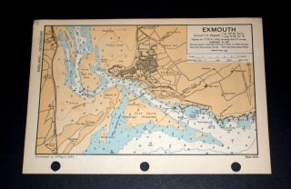
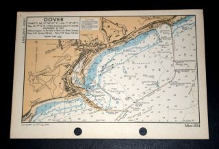
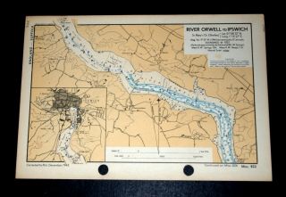
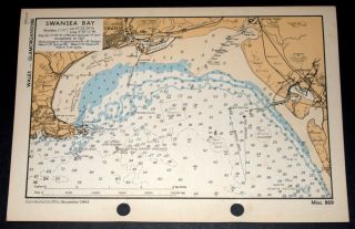
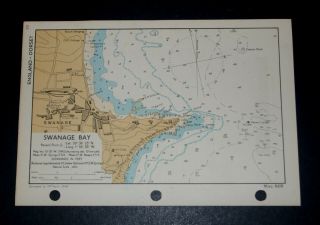
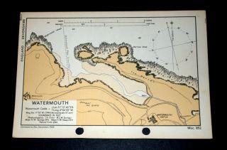
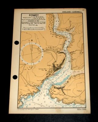
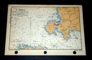
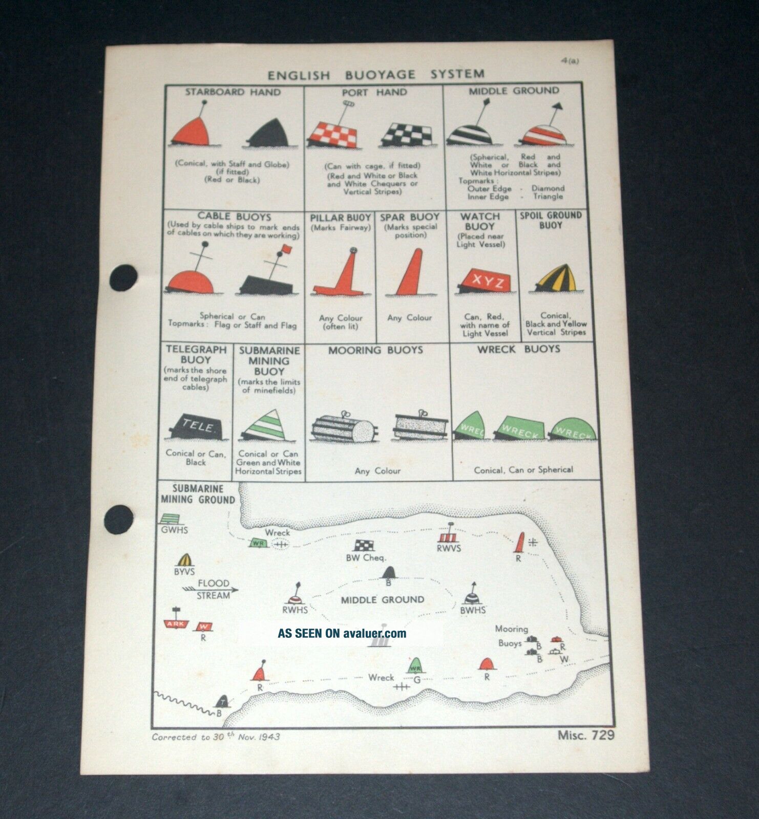
ENGLISH BUOYAGE SYSTEM - Vintage WW2 Naval Military Map Symbols 1943Published by the Hydrographic Department of the Admiralty, for a Naval Handbook.  OriginallyRESTRICTED but now declassified.In good condition showing amazing detail.  Used for Coastal Defence.  Delightful example of fine cartography.Corrected to 30th November 1943.  Printed on fine card.  Overall size: 6.5(w) x 9.5(h) ins.  Suitable for framing.Thisis a genuine map and not a... copy, facsimile or computer generated image.Please see my other auctions/sales for similar.   PAYPAL only.  UK P&P £1.30.  Combined postage available.
     

00049


    Similar items


  • Exmouth,  Devon - Vintage Ww2 Naval Military Map 1943

    Exmouth, Devon - Vintage Ww2 Naval Military Map 1943

  • Dover,  Kent - Vintage Ww2 Naval Military Map 1944

    Dover, Kent - Vintage Ww2 Naval Military Map 1944

  • River Orwell To Ipswich,  Suffolk - Vintage Ww2 Naval Military Map 1943

    River Orwell To Ipswich, Suffolk - Vintage Ww2 Naval Military Map 1943

  • Swansea Bay,  Glamorganshire,  Wales - Vintage Ww2 Naval/military Map 1943

    Swansea Bay, Glamorganshire, Wales - Vintage Ww2 Naval/military Map 1943

  • Swanage Bay,  Dorset - Vintage Ww2 Naval Military Map 1943

    Swanage Bay, Dorset - Vintage Ww2 Naval Military Map 1943

  • - Watermouth,  Devon - Rare Vintage Ww2 Naval Military Map 1943

    - Watermouth, Devon - Rare Vintage Ww2 Naval Military Map 1943

  • - Fowey & Polruan,  Cornwall - Rare Vintage Ww2 Naval Military Map 1943

    - Fowey & Polruan, Cornwall - Rare Vintage Ww2 Naval Military Map 1943

  • - St.  Mary

    - St. Mary ' S, Scilly Isles - Rare Vintage Ww2 Naval Military Map 1943


    • You might also like


    • Hungary & Romania 1579 (1584) Ortelius Unusual Antique Copper Engraved Map

      Hungary & Romania 1579 (1584) Ortelius Unusual Antique Copper Engraved Map

    • Brussels Bruxelles Belfium 1777 De Ferraris & Dupuis Large Antique Map Sheet Xxi

      Brussels Bruxelles Belfium 1777 De Ferraris & Dupuis Large Antique Map Sheet Xxi

    • 1616 Atlas Map Of Iceland.

      1616 Atlas Map Of Iceland.

    • Kazan Russia 1767 Le Clerc/lespinasse Antique Copper Engraved City View

      Kazan Russia 1767 Le Clerc/lespinasse Antique Copper Engraved City View

    • 1899 Stanford,  Folding Map Of Norwich,  Norfolk,  Arthur Collins,  Jarrold & Sons,

      1899 Stanford, Folding Map Of Norwich, Norfolk, Arthur Collins, Jarrold & Sons,

    • 1948 Vintage Linen Colour Map Geological Survey Ten Mile Of Great Britain

      1948 Vintage Linen Colour Map Geological Survey Ten Mile Of Great Britain

    • 1944 Map Flying Bombs Sussex Ww2 Newspaper Military Kent Courier German V1 V2

      1944 Map Flying Bombs Sussex Ww2 Newspaper Military Kent Courier German V1 V2

    • Dated 1638 Vellum Map Of Icklesham Sussex Showing Land Uses Owners Etc

      Dated 1638 Vellum Map Of Icklesham Sussex Showing Land Uses Owners Etc

Avaluer          About Us          Privacy Policy          Contact Us          UP
© 2022, avaluer.net, Inc. or its affiliates