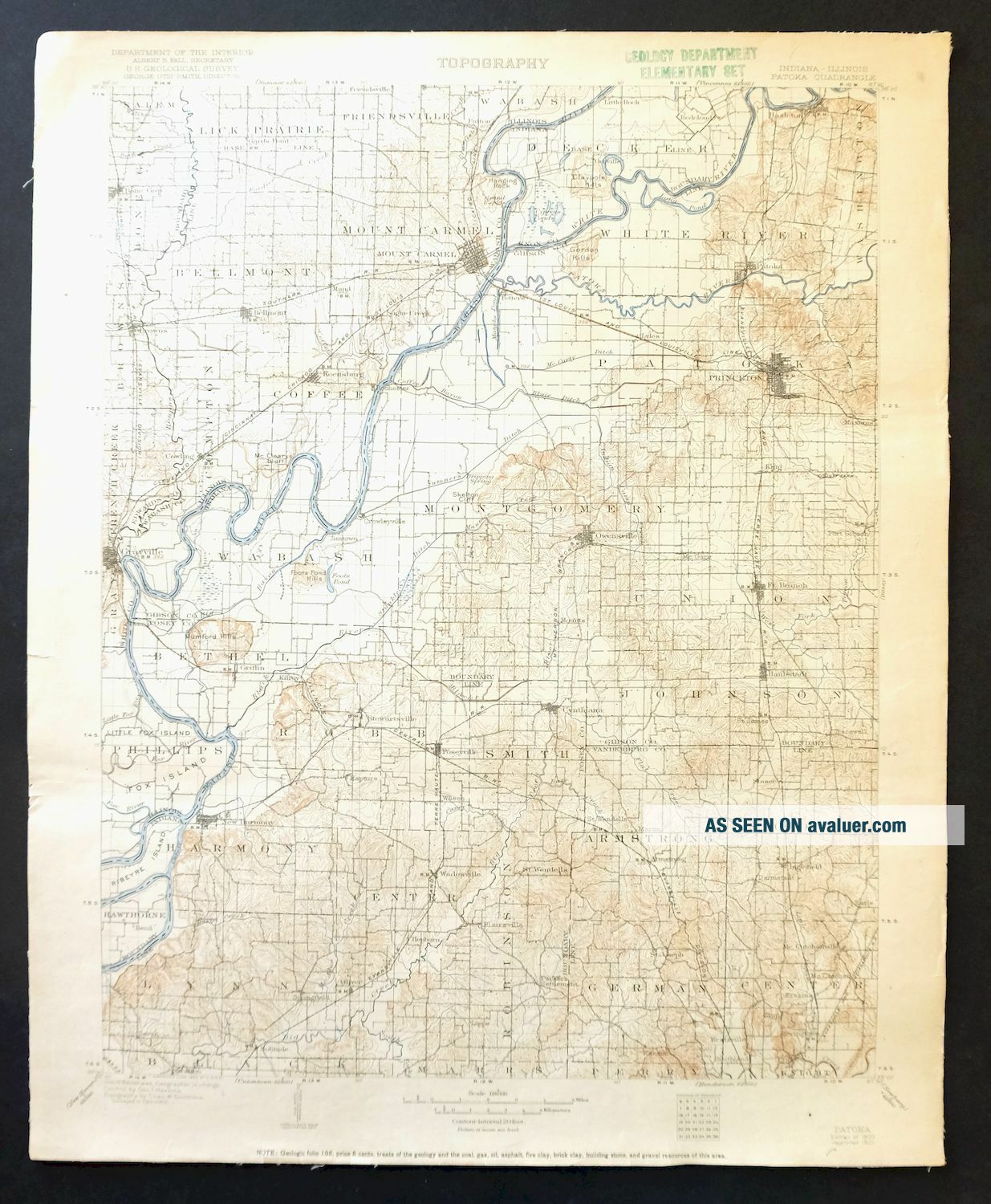
Patoka Indiana Illinois Vintage USGS Topo Map 1903 Evansville Topographical
Item History & Price
PATOKA INDIANA VINTAGE USGS TOPO MAP 1903 Vintage Cartographics Indiana Maps ∙ Antique Prints ∙ Bargain Bin ∙ Browse Nearby Sheets 1903
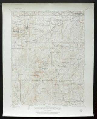
Patoka
Indiana-Illinois
USGS TOPOGRAPHIC MAP
1921 print in very good condition
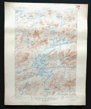
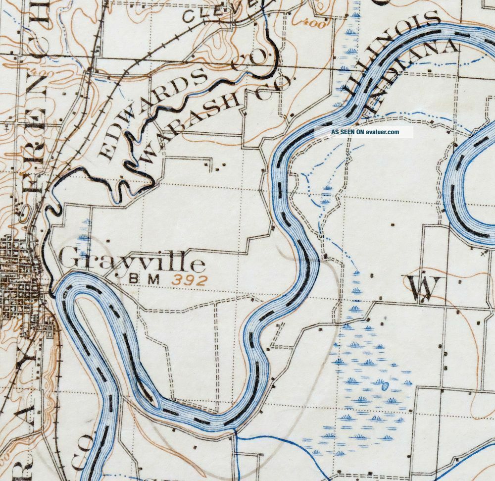
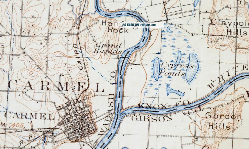
For sale is the 1903 edition of the Patoka 30-minute map. This map would be great for framing or display, historical refere...nce or research, genealogy studies, adding to a collection, treasure hunting, a nice conversation piece, a gift for a history or map enthusiast, or for anyone interested in this area. This sheet includes the only survey done by the United States Geological Survey for the Patoka 30-minute quadrangle. The map sheet is an original 1921 USGS print in very good condition. The Patoka 30-minute map shows roads, paths, towns, railroads, rivers, creeks, elevation contour lines, public land survey lines, county, state, and other administrative boundaries, and many structures (houses, churches, schools, barns, etc.) as they existed at the time of the survey in 1901 and 1902. The Patoka map was surveyed before aerial photography methods were widely used in map data gathering. It was drawn by Geological Survey cartographers based on plane table field survey information as well as information gathered from local residents in the area. It displays the remarkable abilities of the early USGS map makers, who placed a strong emphasis on creating complete, accurate, and cartographically appealing maps. Maps from the USGS 30-minute series have been out of print for many years. They have never been common and original prints are increasingly difficult to find. For areas where the 30-minute map was produced, it is usually the first large-scale survey done by the USGS for that area. These are a valuable historical record for an area, as they contain many placenames and features that have been dropped from more recent series' and editions. MAP DETAILS Title Patoka State Indiana-Illinois Series 30-minute Surveyed 1901 and 1902 Field Survey Geographer Jno. H. Renshawe Engraved 1903 Edition 1903 Printed 1921 Woodland Tint No Scale 1:125000 Contour Interval 20 Foot Sheet Dimensions 16 x 20 inches (approximate) Map Dimensions 13 3/4 x 17 1/2 inches Coverage Area Roughly 28 x 32 miles Notes canvas-backed sheet SHEET CONDITION For maps of this vintage, effort is made to note all visible flaws, no matter how minor. Overall Condition VERY GOOD Sheet Notes lightly handled, never folded, attractively age-toned paper, has original canvas-backing Map Area no wear, no blemishes, minor pencil markings within map area Collar Area minor edge wear or tears, very minor markings, very minor blemishes, inventory stamp on top collar MAP COVERAGE Quadrangle extent overlaid on current basemap. Browse Nearby
Sheets PLACENAMES Depending on map series and survey date, all of the features listed below may not be shown on this map. This list contains features that currently exist or historically existed within the area covered by this map. The list can be used as a reference to determine if this map covers your area of interest. Placenames are listed alphabetically next to each feature type. Cities and Towns (current) Bellmont, Bone Gap, Browns, Cynthiana, Darmstadt, Evansville, Fort Branch, Grayville, Griffin, Haubstadt, Hazleton, Highland, Inglefield, Kasson, Keensburg, Melody Hill, Mount Carmel, New Harmony, Owensville, Patoka, Patton, Poseyville, Princeton, Solitude, and Wadesville Counties Covered Edwards, Gibson, Knox, Posey, Vanderburgh, Wabash, and White Rivers and Streams Barr Creek, Big Bayou, Big Creek, Black River, Bonpas Creek, Book Run, Buck Creek, Buente Creek, Carpentier Creek, Coffee Bayou, Coffee Creek, Crawfish Creek, Fordice Creek, Fox River, French Creek, French Run, Fun Creek, Goad Brook, Greathouse Creek, Harmony Creek, Hawthorne Creek, Higginbotham Ditch, Hurricane Creek, Indian Creek, Jordan Creek, Large Drain, Lick Creek, Little Creek, Little Fox River, Little Pigeon Creek, Locust Creek, Long Run, McAdoo Creek, Mud Creek, Negro Creek, Neu Creek, Old Brook, Old Channel Wabash River, Olive Creek, Patoka River, Pigeon Creek, Robb Creek, Rush Creek, Sand Creek, Sandy Creek, Skelton Creek, Sugar Creek, Tri Brook, Wabash River, Wabash River Old Channel, Walser Creek, West Fork Pigeon Creek, and White River Water Bodies Bittner Lake, Broad Pond, Burnet Pond, Claypole Pond, Conservation Lake, Edgewater Lake, Foote Pond, Harold Mann Lake, Kahr Lake, Knowles Lake, Lake Gibson, LaRoche Lake, Long Pond, Lost Lake, Mater Dei Provincial Lake, Morgan Lake, North Estates Lake, Pahoka Camp Lake, Ray Nell Acres Lake, Russell Pond, Wabash Pond, and Weirs Lake IN INDIANA Populated Places: Armstrong, Baldwin Heights, Barrett, Blairsville, Country Club Meadows, Crawleyville, Cynthiana, Darmstadt, Decker Chapel, Douglas, Durham, Earle, East Mount Carmel, McCutchanville, McGary, Mechanicsville, Melody Hill, Egg Harbor, Erskine Station, Fort Branch, Grafton, Griffin, Harwood, Haubstadt, Hazleton, Hepburn, Hickory Ridge, Highland, Hillsdale, Inglefield, Jimtown, Johnson, Kasson, King, Knob Hill, Kratzville, Lakewood Hills, Lippe, Little Rock, Lyles, Martin, Mounts, New Baltimore, New Harmony, Nisbet, Oliver, Orrville, Owensville, Parkers Settlement, Patoka, Poseyville, Princeton, Rapture, Saint James, Saint Joseph, Saint Wendel, Savah, Skelton, Solitude, Springfield, Stacer, Stewartsville, Stringtown, Wadesville, Warrenton, and White River. Post Offices: Solitude Post Office. Locations: Clearcrest Country Club, Millers Station, Evansville Country Club, Fields Station, North Park Shopping Center, Princeton Country Club, Princeton Waterworks, and Wilson Community Center. Administrative Boundaries: Township of Armstrong, Township of Bethel, Township of Center, Township of Center, Township of Decker, Township of Montgomery, Township of German, Township of Harmony, Township of Johnson, Township of Lynn, Township of Patoka, Township of Robb, Township of Robinson, Township of Scott, Township of Smith, Township of Union, Township of Wabash, and Township of White River. Mountain Ranges: Foote Pond Hills, Gordon Hills, Mumford Hills, and Orrville Hills. Mountains, Peaks, and Summits: Bald Hill and Sand Hill. Reserves: Luke Decker Claim. Valleys and Canyons: Patton Hollow. Parks: Camp Carson, Camp Pahoka, Camp Reveal, Continental Camp, Harmonie State Park, Lafayette Park, Murphy Park, Nash Park, New Harmony State Memorial, South Side Park, and The Labyrinth State Memorial. Drainages: Alexander Creek, Andrews Run, Barr Creek, Barren Creek, Beech Grove Run, Bend Run, Big Bayou, Black River, Book Run, Buente Creek, Caney Creek, Clark Run, Coffee Bayou, Coon Creek, Cord Run, Cox Creek, David Run, Duo Run, Mauck Run, McAdoo Creek, Melody Run, French Run, Fun Creek, Gin Run, Goad Brook, Ha Brook Creek, Hand Branch, Harmony Creek, Hawthorne Creek, Hurricane Creek, Indian Creek, Johnson Drain, Jordan Creek, Large Drain, Lick Creek, Lilly Run, Little Creek, Little Pigeon Creek, Long Run, Maple Run, Murphy Run, Nest Run, Oka Run, Old Beech Creek, Old Brook, Old Channel Wabash River, Olive Creek, Oliver Run, Owen Run, Pahoka Creek, Paper Run, Patoka River, Raben Branch, Richland Creek, Road Brook, Robb Creek, Rush Creek, Sand Creek, Sandy Creek, Seed Run, Skelton Branch, Skelton Creek, Smith Run, Solitude Run, Swift Run, Thorn Run, Thrall Run, Tri Brook, Uno Run, Wabash River Old Channel, War Branch, West Fork Pigeon Creek, White River, and Wilson Brook. Islands: Coffee Island, Kingdom Island, Patoka Island, Pearl Island, and Ribeyre Island. Churches: Antioch Church, Bethel Church, Bethesda Church, Bethlehem Church, Bethsaida Church, Black River Church, Blythe Chapel, Calverts Chapel, Centenary Church, Columbia Church, Decker Chapel, Maumee Church, Memorial Church, Enon Church, Hight Chapel, Immanuel Church, Mount Pleasant Church, Mount Zion Church, New Liberty Church, Old Union Church, Olive Chapel, Richland Church, Saint Lucas Church, Saint Pauls Church, Saint Peters Church, Saint Stephen Church, Salem Church, Shiloh Church, Slate Hill Church, Steelman Chapel, Winfield Church, and Zoar Church. Lakes and Ponds: Burnet Pond, Claypole Pond, Maucks Pond, Foote Pond, Goose Pond, Knowles Lake, LaRoche Lake, Long Pond, Lost Lake, and Weirs Lake. Canals: Belcher Ditch, Blair Ditch, Blood Ditch, Brown Ditch, McCarty Ditch, McGary Ditch, McGray Ditch, Montgomery Ditch, Emerson Ditch, Franks Ditch, Hickory Ridge Lateral, Higginbotham Ditch, Hull Ditch, Hurricane Creek Ditch, Johnson Ditch, Keniepe Lateral, Lillard Ditch, Little Sumner Ditch, Loefler Ditch, Maidlow Ditch, Newman Lateral, Pond Flat Ditch, Saunders Ditch, Scott Ditch, Scott Lateral, Stormont Ditch, Thompson Ditch, Toops Ditch, Trippet Ditch, Wallenmeyer Ditch, Watson Lateral, and Watts Ditch. Dams: Bittner Lake Dam, Mater Dei Provincial Lake Dam, Edgewater Lake Dam, Gibson Public Service Generation Plant Dam, Harold Mann Lake Dam, Kahre Lake Dam, Lake Gibson Conservation Dam, Morgan Lake Dam, North Lake Estates Lake Dam, Pahoka Camp Lake Dam, Ray Nell Acres Lake Dam, and Schnake Lake Dam. Bends: Peankishaw Bend. Reservoirs and Tanks: Bittner Lake, Mater Dei Provincial Lake, Edgewater Lake, Harold Mann Lake, Kahr Lake, Lake Gibson, Morgan Lake, North Estates Lake, Pahoka Camp Lake, Ray Nell Acres Lake, and Schnake Lake. Swamps: Broad Pond and Cypress Swamps. Rapids: Grand Rapids and Kellys Ripple. Towers: WKKR-AM (Evansville), WPSR-FM (Evansville), WRAY-FM (Princeton), and WYNG-FM (Evansville). Oilfields: Oliver Underground Gas Storage Area. Airports: Evansville Dress Regional Airport, Hepler Airport, Hull Airport, Skylane Airport, and Stierley Airport. Bayous and Sloughs: Coffee Bayou. Schools: Baldwin Heights Elementary School, Cynthia Heights Elementary and Junior High School, Decker Elementary School, Evans Elementary and Junior High School, Franklin School, Harwood Elementary and Junior High School, Haubstadt Public School, Highland Elementary and Junior High School, Holy Redeemer School, Lowell Elementary School, Lynch School, North Posey Junior High School, North Posey Senior High School, Oak Hill Elementary and Junior High School, Owensville Public School, Princeton Community High School, Purdue University Horticultural Farm, Rex Mundi High School, Riley School, Saint Joseph School, South Terrace Elementary School, Stockwell Elementary School, Stringtown Elementary and Junior High School, Thompkins Elementary and Junior High School, and Upper Hill School. IN ILLINOIS Populated Places: Bellmont, Bone Gap, Browns, Cherry Hill Estates, Cowling, Gards Point, Grayville, Keensburg, Maud, Mount Carmel, Odgen, Patton, Rochester, and Schrodts Station. Post Offices: Mount Carmel Post Office. Locations: Webbs Ferry and Mount Carmel Ferry. Areas: Frazier Prairie. Administrative Boundaries: Bellmont Election Precinct, Browns Election Precinct, Coffee Election Precinct, Compton Election Precinct, Lick Prairie Election Precinct, and Mount Carmel Election Precinct. Woods: Beall Woods. Parks: Beall Woods State Conservation and Natural Area. Drainages: Fox River, French Creek, Little Fox River, Bonpas Creek, Buck Creek, Coffee Creek, Crawfish Creek, Fordice Creek, Greathouse Creek, Indian Creek, Mud Creek, Negro Creek, Sugar Creek, and Walser Creek. Islands: Bull Island, Fox Island, Little Fox Island, Turkey Island, and Duck Island. Churches: Abundant Life New Life Fellowship Church, Antioch Church, Asbury Chapel, Bone Gap Christian Church, Bone Gap United Methodist Church, Church of the Nazarene, Emmanuel Baptist Church, First Baptist Church, First Christian Church, First Presbyterian Church, First United Methodist Church, Fortney United Methodist Church, Free Methodist Church, Friedens Church, Gospel Kingdom Church, Lick Prairie Christian Church, Nisbet Chapel, Nye Chapel United Methodist Church, Pentecostal Assembly of God Church, Saint John the Baptist Episcopal Church, Saint Johns Church, Saint Marys Catholic Church, Saint Sebastian Catholic Church, Trinity United Methodist Church, and Zion Evangelical Lutheran Church. Hospitals: General Baptist Nursing Home and Wabash General Hospital. Lakes and Ponds: Lost Lake and Russell Pond. Bluffs: McCleary Bluff and Hanging Rock. Channels: Old Channel. Dams: Wabash Valley Club Conservation Lake Dam. Buildings: Grayville Public Library, Mount Carmel City Building, Mount Carmel Public Library, and Wabash County Courthouse. Bridges: New Harmony Bridge. Bends: Bowman Bend, Peankishaw Bend, and Schuh Bend. Ridges: Poplar Ridge. Reservoirs and Tanks: Conservation Lake. Towers: WRBT-FM (Mount Carmel), WVJC-FM (Mount Carmel), and WYER-AM (Mount Carmel). Levees: Denham Levee and Rochester And McCleary Bluffs Levee. Airports: Beckerman Field, Nelson Private Airport, Smith Airport, and Wabash General Hospital Heliport. Bayous and Sloughs: Rattling Slough. Schools: Bellmont Elementary School, Mount Carmel High School, North Middle School, Saint Marys School, South Elementary School, and Wabash Valley College. SHIPPING AND RETURNS This map sheet will be carefully rolled in a sturdy tube and shipped via the US Postal Service. Shipping and handling costs are included in the purchase price.
If you find that the sheet you receive is not as described in the listing, you may ship it back to us for a refund of the purchase price. 15~7755 15~7756 15~7757 15~7758 15~7759 15~7952 15~7953 15~7954 15~7955 15~7956 15~8148 15~8149 15~8150 15~8151 15~8152 15~8153 15~8154 15~8342 15~8343 15~8344 15~8345 15~8346 15~8347 15~8348 15~8349 15~8537 15~8538 15~8539 15~8540 15~8541 15~8542 15~8543 15~8544 15~8732 15~8733 15~8734 15~8735 15~8736 15~8737 30~2150 30~2151 75~30369 75~30370 75~30371 75~30372 75~30373 75~30374 75~30754 75~30755 75~30756 75~30757 75~30758 75~30759 75~30760 75~30761 75~31139 75~31140 75~31141 75~31142 75~31143 75~31144 75~31145 75~31146 75~31522 75~31523 75~31524 75~31525 75~31526 75~31527 75~31528 75~31529 75~31905 75~31906 75~31907 75~31908 75~31909 75~31910 75~31911 75~31912 75~32293 75~32294 75~32295 75~32296 75~32297 75~32298
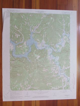
Patoka
Indiana-Illinois
USGS TOPOGRAPHIC MAP
1921 print in very good condition
For sale is the 1903 edition of the Patoka 30-minute map. This map would be great for framing or display, historical refere...nce or research, genealogy studies, adding to a collection, treasure hunting, a nice conversation piece, a gift for a history or map enthusiast, or for anyone interested in this area. This sheet includes the only survey done by the United States Geological Survey for the Patoka 30-minute quadrangle. The map sheet is an original 1921 USGS print in very good condition. The Patoka 30-minute map shows roads, paths, towns, railroads, rivers, creeks, elevation contour lines, public land survey lines, county, state, and other administrative boundaries, and many structures (houses, churches, schools, barns, etc.) as they existed at the time of the survey in 1901 and 1902. The Patoka map was surveyed before aerial photography methods were widely used in map data gathering. It was drawn by Geological Survey cartographers based on plane table field survey information as well as information gathered from local residents in the area. It displays the remarkable abilities of the early USGS map makers, who placed a strong emphasis on creating complete, accurate, and cartographically appealing maps. Maps from the USGS 30-minute series have been out of print for many years. They have never been common and original prints are increasingly difficult to find. For areas where the 30-minute map was produced, it is usually the first large-scale survey done by the USGS for that area. These are a valuable historical record for an area, as they contain many placenames and features that have been dropped from more recent series' and editions. MAP DETAILS Title Patoka State Indiana-Illinois Series 30-minute Surveyed 1901 and 1902 Field Survey Geographer Jno. H. Renshawe Engraved 1903 Edition 1903 Printed 1921 Woodland Tint No Scale 1:125000 Contour Interval 20 Foot Sheet Dimensions 16 x 20 inches (approximate) Map Dimensions 13 3/4 x 17 1/2 inches Coverage Area Roughly 28 x 32 miles Notes canvas-backed sheet SHEET CONDITION For maps of this vintage, effort is made to note all visible flaws, no matter how minor. Overall Condition VERY GOOD Sheet Notes lightly handled, never folded, attractively age-toned paper, has original canvas-backing Map Area no wear, no blemishes, minor pencil markings within map area Collar Area minor edge wear or tears, very minor markings, very minor blemishes, inventory stamp on top collar MAP COVERAGE Quadrangle extent overlaid on current basemap. Browse Nearby
Sheets PLACENAMES Depending on map series and survey date, all of the features listed below may not be shown on this map. This list contains features that currently exist or historically existed within the area covered by this map. The list can be used as a reference to determine if this map covers your area of interest. Placenames are listed alphabetically next to each feature type. Cities and Towns (current) Bellmont, Bone Gap, Browns, Cynthiana, Darmstadt, Evansville, Fort Branch, Grayville, Griffin, Haubstadt, Hazleton, Highland, Inglefield, Kasson, Keensburg, Melody Hill, Mount Carmel, New Harmony, Owensville, Patoka, Patton, Poseyville, Princeton, Solitude, and Wadesville Counties Covered Edwards, Gibson, Knox, Posey, Vanderburgh, Wabash, and White Rivers and Streams Barr Creek, Big Bayou, Big Creek, Black River, Bonpas Creek, Book Run, Buck Creek, Buente Creek, Carpentier Creek, Coffee Bayou, Coffee Creek, Crawfish Creek, Fordice Creek, Fox River, French Creek, French Run, Fun Creek, Goad Brook, Greathouse Creek, Harmony Creek, Hawthorne Creek, Higginbotham Ditch, Hurricane Creek, Indian Creek, Jordan Creek, Large Drain, Lick Creek, Little Creek, Little Fox River, Little Pigeon Creek, Locust Creek, Long Run, McAdoo Creek, Mud Creek, Negro Creek, Neu Creek, Old Brook, Old Channel Wabash River, Olive Creek, Patoka River, Pigeon Creek, Robb Creek, Rush Creek, Sand Creek, Sandy Creek, Skelton Creek, Sugar Creek, Tri Brook, Wabash River, Wabash River Old Channel, Walser Creek, West Fork Pigeon Creek, and White River Water Bodies Bittner Lake, Broad Pond, Burnet Pond, Claypole Pond, Conservation Lake, Edgewater Lake, Foote Pond, Harold Mann Lake, Kahr Lake, Knowles Lake, Lake Gibson, LaRoche Lake, Long Pond, Lost Lake, Mater Dei Provincial Lake, Morgan Lake, North Estates Lake, Pahoka Camp Lake, Ray Nell Acres Lake, Russell Pond, Wabash Pond, and Weirs Lake IN INDIANA Populated Places: Armstrong, Baldwin Heights, Barrett, Blairsville, Country Club Meadows, Crawleyville, Cynthiana, Darmstadt, Decker Chapel, Douglas, Durham, Earle, East Mount Carmel, McCutchanville, McGary, Mechanicsville, Melody Hill, Egg Harbor, Erskine Station, Fort Branch, Grafton, Griffin, Harwood, Haubstadt, Hazleton, Hepburn, Hickory Ridge, Highland, Hillsdale, Inglefield, Jimtown, Johnson, Kasson, King, Knob Hill, Kratzville, Lakewood Hills, Lippe, Little Rock, Lyles, Martin, Mounts, New Baltimore, New Harmony, Nisbet, Oliver, Orrville, Owensville, Parkers Settlement, Patoka, Poseyville, Princeton, Rapture, Saint James, Saint Joseph, Saint Wendel, Savah, Skelton, Solitude, Springfield, Stacer, Stewartsville, Stringtown, Wadesville, Warrenton, and White River. Post Offices: Solitude Post Office. Locations: Clearcrest Country Club, Millers Station, Evansville Country Club, Fields Station, North Park Shopping Center, Princeton Country Club, Princeton Waterworks, and Wilson Community Center. Administrative Boundaries: Township of Armstrong, Township of Bethel, Township of Center, Township of Center, Township of Decker, Township of Montgomery, Township of German, Township of Harmony, Township of Johnson, Township of Lynn, Township of Patoka, Township of Robb, Township of Robinson, Township of Scott, Township of Smith, Township of Union, Township of Wabash, and Township of White River. Mountain Ranges: Foote Pond Hills, Gordon Hills, Mumford Hills, and Orrville Hills. Mountains, Peaks, and Summits: Bald Hill and Sand Hill. Reserves: Luke Decker Claim. Valleys and Canyons: Patton Hollow. Parks: Camp Carson, Camp Pahoka, Camp Reveal, Continental Camp, Harmonie State Park, Lafayette Park, Murphy Park, Nash Park, New Harmony State Memorial, South Side Park, and The Labyrinth State Memorial. Drainages: Alexander Creek, Andrews Run, Barr Creek, Barren Creek, Beech Grove Run, Bend Run, Big Bayou, Black River, Book Run, Buente Creek, Caney Creek, Clark Run, Coffee Bayou, Coon Creek, Cord Run, Cox Creek, David Run, Duo Run, Mauck Run, McAdoo Creek, Melody Run, French Run, Fun Creek, Gin Run, Goad Brook, Ha Brook Creek, Hand Branch, Harmony Creek, Hawthorne Creek, Hurricane Creek, Indian Creek, Johnson Drain, Jordan Creek, Large Drain, Lick Creek, Lilly Run, Little Creek, Little Pigeon Creek, Long Run, Maple Run, Murphy Run, Nest Run, Oka Run, Old Beech Creek, Old Brook, Old Channel Wabash River, Olive Creek, Oliver Run, Owen Run, Pahoka Creek, Paper Run, Patoka River, Raben Branch, Richland Creek, Road Brook, Robb Creek, Rush Creek, Sand Creek, Sandy Creek, Seed Run, Skelton Branch, Skelton Creek, Smith Run, Solitude Run, Swift Run, Thorn Run, Thrall Run, Tri Brook, Uno Run, Wabash River Old Channel, War Branch, West Fork Pigeon Creek, White River, and Wilson Brook. Islands: Coffee Island, Kingdom Island, Patoka Island, Pearl Island, and Ribeyre Island. Churches: Antioch Church, Bethel Church, Bethesda Church, Bethlehem Church, Bethsaida Church, Black River Church, Blythe Chapel, Calverts Chapel, Centenary Church, Columbia Church, Decker Chapel, Maumee Church, Memorial Church, Enon Church, Hight Chapel, Immanuel Church, Mount Pleasant Church, Mount Zion Church, New Liberty Church, Old Union Church, Olive Chapel, Richland Church, Saint Lucas Church, Saint Pauls Church, Saint Peters Church, Saint Stephen Church, Salem Church, Shiloh Church, Slate Hill Church, Steelman Chapel, Winfield Church, and Zoar Church. Lakes and Ponds: Burnet Pond, Claypole Pond, Maucks Pond, Foote Pond, Goose Pond, Knowles Lake, LaRoche Lake, Long Pond, Lost Lake, and Weirs Lake. Canals: Belcher Ditch, Blair Ditch, Blood Ditch, Brown Ditch, McCarty Ditch, McGary Ditch, McGray Ditch, Montgomery Ditch, Emerson Ditch, Franks Ditch, Hickory Ridge Lateral, Higginbotham Ditch, Hull Ditch, Hurricane Creek Ditch, Johnson Ditch, Keniepe Lateral, Lillard Ditch, Little Sumner Ditch, Loefler Ditch, Maidlow Ditch, Newman Lateral, Pond Flat Ditch, Saunders Ditch, Scott Ditch, Scott Lateral, Stormont Ditch, Thompson Ditch, Toops Ditch, Trippet Ditch, Wallenmeyer Ditch, Watson Lateral, and Watts Ditch. Dams: Bittner Lake Dam, Mater Dei Provincial Lake Dam, Edgewater Lake Dam, Gibson Public Service Generation Plant Dam, Harold Mann Lake Dam, Kahre Lake Dam, Lake Gibson Conservation Dam, Morgan Lake Dam, North Lake Estates Lake Dam, Pahoka Camp Lake Dam, Ray Nell Acres Lake Dam, and Schnake Lake Dam. Bends: Peankishaw Bend. Reservoirs and Tanks: Bittner Lake, Mater Dei Provincial Lake, Edgewater Lake, Harold Mann Lake, Kahr Lake, Lake Gibson, Morgan Lake, North Estates Lake, Pahoka Camp Lake, Ray Nell Acres Lake, and Schnake Lake. Swamps: Broad Pond and Cypress Swamps. Rapids: Grand Rapids and Kellys Ripple. Towers: WKKR-AM (Evansville), WPSR-FM (Evansville), WRAY-FM (Princeton), and WYNG-FM (Evansville). Oilfields: Oliver Underground Gas Storage Area. Airports: Evansville Dress Regional Airport, Hepler Airport, Hull Airport, Skylane Airport, and Stierley Airport. Bayous and Sloughs: Coffee Bayou. Schools: Baldwin Heights Elementary School, Cynthia Heights Elementary and Junior High School, Decker Elementary School, Evans Elementary and Junior High School, Franklin School, Harwood Elementary and Junior High School, Haubstadt Public School, Highland Elementary and Junior High School, Holy Redeemer School, Lowell Elementary School, Lynch School, North Posey Junior High School, North Posey Senior High School, Oak Hill Elementary and Junior High School, Owensville Public School, Princeton Community High School, Purdue University Horticultural Farm, Rex Mundi High School, Riley School, Saint Joseph School, South Terrace Elementary School, Stockwell Elementary School, Stringtown Elementary and Junior High School, Thompkins Elementary and Junior High School, and Upper Hill School. IN ILLINOIS Populated Places: Bellmont, Bone Gap, Browns, Cherry Hill Estates, Cowling, Gards Point, Grayville, Keensburg, Maud, Mount Carmel, Odgen, Patton, Rochester, and Schrodts Station. Post Offices: Mount Carmel Post Office. Locations: Webbs Ferry and Mount Carmel Ferry. Areas: Frazier Prairie. Administrative Boundaries: Bellmont Election Precinct, Browns Election Precinct, Coffee Election Precinct, Compton Election Precinct, Lick Prairie Election Precinct, and Mount Carmel Election Precinct. Woods: Beall Woods. Parks: Beall Woods State Conservation and Natural Area. Drainages: Fox River, French Creek, Little Fox River, Bonpas Creek, Buck Creek, Coffee Creek, Crawfish Creek, Fordice Creek, Greathouse Creek, Indian Creek, Mud Creek, Negro Creek, Sugar Creek, and Walser Creek. Islands: Bull Island, Fox Island, Little Fox Island, Turkey Island, and Duck Island. Churches: Abundant Life New Life Fellowship Church, Antioch Church, Asbury Chapel, Bone Gap Christian Church, Bone Gap United Methodist Church, Church of the Nazarene, Emmanuel Baptist Church, First Baptist Church, First Christian Church, First Presbyterian Church, First United Methodist Church, Fortney United Methodist Church, Free Methodist Church, Friedens Church, Gospel Kingdom Church, Lick Prairie Christian Church, Nisbet Chapel, Nye Chapel United Methodist Church, Pentecostal Assembly of God Church, Saint John the Baptist Episcopal Church, Saint Johns Church, Saint Marys Catholic Church, Saint Sebastian Catholic Church, Trinity United Methodist Church, and Zion Evangelical Lutheran Church. Hospitals: General Baptist Nursing Home and Wabash General Hospital. Lakes and Ponds: Lost Lake and Russell Pond. Bluffs: McCleary Bluff and Hanging Rock. Channels: Old Channel. Dams: Wabash Valley Club Conservation Lake Dam. Buildings: Grayville Public Library, Mount Carmel City Building, Mount Carmel Public Library, and Wabash County Courthouse. Bridges: New Harmony Bridge. Bends: Bowman Bend, Peankishaw Bend, and Schuh Bend. Ridges: Poplar Ridge. Reservoirs and Tanks: Conservation Lake. Towers: WRBT-FM (Mount Carmel), WVJC-FM (Mount Carmel), and WYER-AM (Mount Carmel). Levees: Denham Levee and Rochester And McCleary Bluffs Levee. Airports: Beckerman Field, Nelson Private Airport, Smith Airport, and Wabash General Hospital Heliport. Bayous and Sloughs: Rattling Slough. Schools: Bellmont Elementary School, Mount Carmel High School, North Middle School, Saint Marys School, South Elementary School, and Wabash Valley College. SHIPPING AND RETURNS This map sheet will be carefully rolled in a sturdy tube and shipped via the US Postal Service. Shipping and handling costs are included in the purchase price.
If you find that the sheet you receive is not as described in the listing, you may ship it back to us for a refund of the purchase price. 15~7755 15~7756 15~7757 15~7758 15~7759 15~7952 15~7953 15~7954 15~7955 15~7956 15~8148 15~8149 15~8150 15~8151 15~8152 15~8153 15~8154 15~8342 15~8343 15~8344 15~8345 15~8346 15~8347 15~8348 15~8349 15~8537 15~8538 15~8539 15~8540 15~8541 15~8542 15~8543 15~8544 15~8732 15~8733 15~8734 15~8735 15~8736 15~8737 30~2150 30~2151 75~30369 75~30370 75~30371 75~30372 75~30373 75~30374 75~30754 75~30755 75~30756 75~30757 75~30758 75~30759 75~30760 75~30761 75~31139 75~31140 75~31141 75~31142 75~31143 75~31144 75~31145 75~31146 75~31522 75~31523 75~31524 75~31525 75~31526 75~31527 75~31528 75~31529 75~31905 75~31906 75~31907 75~31908 75~31909 75~31910 75~31911 75~31912 75~32293 75~32294 75~32295 75~32296 75~32297 75~32298