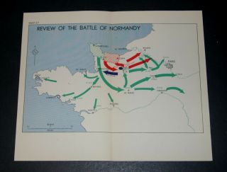
WW2 D - Day Overlord THE INITIAL DEVELOPMENT OF THE BRIDGEHEAD 13 - 18 June 1944


Item History & Price

Information:
Reference Number: Avaluer:1249399Cartographer/Publisher: Admiralty
Year: 1943Original/Reproduction: Vintage Original
City: Caen CherbourgFormat: School Map
Country/Region: FranceType: Military Map
Era: 1940s
Original Description:
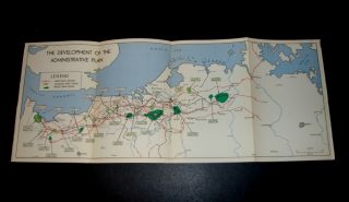
WW2 D-Day Overlord THE INITIAL DEVELOPMENT OF THE BRIDGEHEAD 13-18 June 1944On the western flank, operations against Cherbourg continued with the cutting off of the Cotentin peninsula and the concentration of forces for the drive on Cherbourg, while farther east enemy attempts to regain Carentan were successfully resisted.Map in good condition, folded.  Overall size 37.6(w) x 21.0(h) cms. Ref: M12Thisis a genuine map and not a copy, facsimile or computer generated image.Please see... my other auctions/sales for similar.   PAYPAL only.  UK P&P £1.30.  Combined postage available.
    

00037


    Similar items


  • Ww2 D - Day Overlord Map Of The Development Of The Administrative Plan June 1944

    Ww2 D - Day Overlord Map Of The Development Of The Administrative Plan June 1944

  • Ww2 D - Day Overlord Map The Advance To The River Seine 21 Aug 1944 France

    Ww2 D - Day Overlord Map The Advance To The River Seine 21 Aug 1944 France

  • Ww2 D - Day Overlord Invasion Of France,  Map Of The Situation On 30 June 1944

    Ww2 D - Day Overlord Invasion Of France, Map Of The Situation On 30 June 1944

  • Ww2 D - Day Overlord Map Review Of The Battle Of Normandy June 1944

    Ww2 D - Day Overlord Map Review Of The Battle Of Normandy June 1944

  • Ww2 D - Day Overlord Map Of Closing Of The Falaise " Pocket " 18 - 20 Aug 1944 France

    Ww2 D - Day Overlord Map Of Closing Of The Falaise " Pocket " 18 - 20 Aug 1944 France

  • Ww2 D - Day Overlord Map Of The Crossing Of River Seine 21 Army Group 25 Aug 1944

    Ww2 D - Day Overlord Map Of The Crossing Of River Seine 21 Army Group 25 Aug 1944

  • Ww2 D - Day Overlord Map Review Of The Battle Of Normandy June 1944

    Ww2 D - Day Overlord Map Review Of The Battle Of Normandy June 1944

  • Ww2 D - Day Overlord Map Of Closing Of The Falaise " Pocket " 18 - 20 Aug 1944 France

    Ww2 D - Day Overlord Map Of Closing Of The Falaise " Pocket " 18 - 20 Aug 1944 France


    • You might also like


    • Hungary & Romania 1579 (1584) Ortelius Unusual Antique Copper Engraved Map

      Hungary & Romania 1579 (1584) Ortelius Unusual Antique Copper Engraved Map

    • Brussels Bruxelles Belfium 1777 De Ferraris & Dupuis Large Antique Map Sheet Xxi

      Brussels Bruxelles Belfium 1777 De Ferraris & Dupuis Large Antique Map Sheet Xxi

    • 1616 Atlas Map Of Iceland.

      1616 Atlas Map Of Iceland.

    • Kazan Russia 1767 Le Clerc/lespinasse Antique Copper Engraved City View

      Kazan Russia 1767 Le Clerc/lespinasse Antique Copper Engraved City View

    • 1899 Stanford,  Folding Map Of Norwich,  Norfolk,  Arthur Collins,  Jarrold & Sons,

      1899 Stanford, Folding Map Of Norwich, Norfolk, Arthur Collins, Jarrold & Sons,

    • 1948 Vintage Linen Colour Map Geological Survey Ten Mile Of Great Britain

      1948 Vintage Linen Colour Map Geological Survey Ten Mile Of Great Britain

    • 1944 Map Flying Bombs Sussex Ww2 Newspaper Military Kent Courier German V1 V2

      1944 Map Flying Bombs Sussex Ww2 Newspaper Military Kent Courier German V1 V2

    • Dated 1638 Vellum Map Of Icklesham Sussex Showing Land Uses Owners Etc

      Dated 1638 Vellum Map Of Icklesham Sussex Showing Land Uses Owners Etc

Avaluer          About Us          Privacy Policy          Contact Us          UP
© 2022, avaluer.net, Inc. or its affiliates