ENGLISH CENTRAL MIDLANDS: A RARE ELONGATED ORDNANCE MAP - 1922 TOPOGRAPHIC COLOUR
Item History & Price
VINTAGEMAP- SOLD FOR £16 ONLY- NO AUCTION- NO POSTAGE FEE FOR 2ND CLASS UK. “PERSPECTIVES ON BRITAIN: TRAVELLING WITH ANANTIQUE OR VINTAGE MAP”seller'scode: 220320182
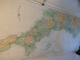
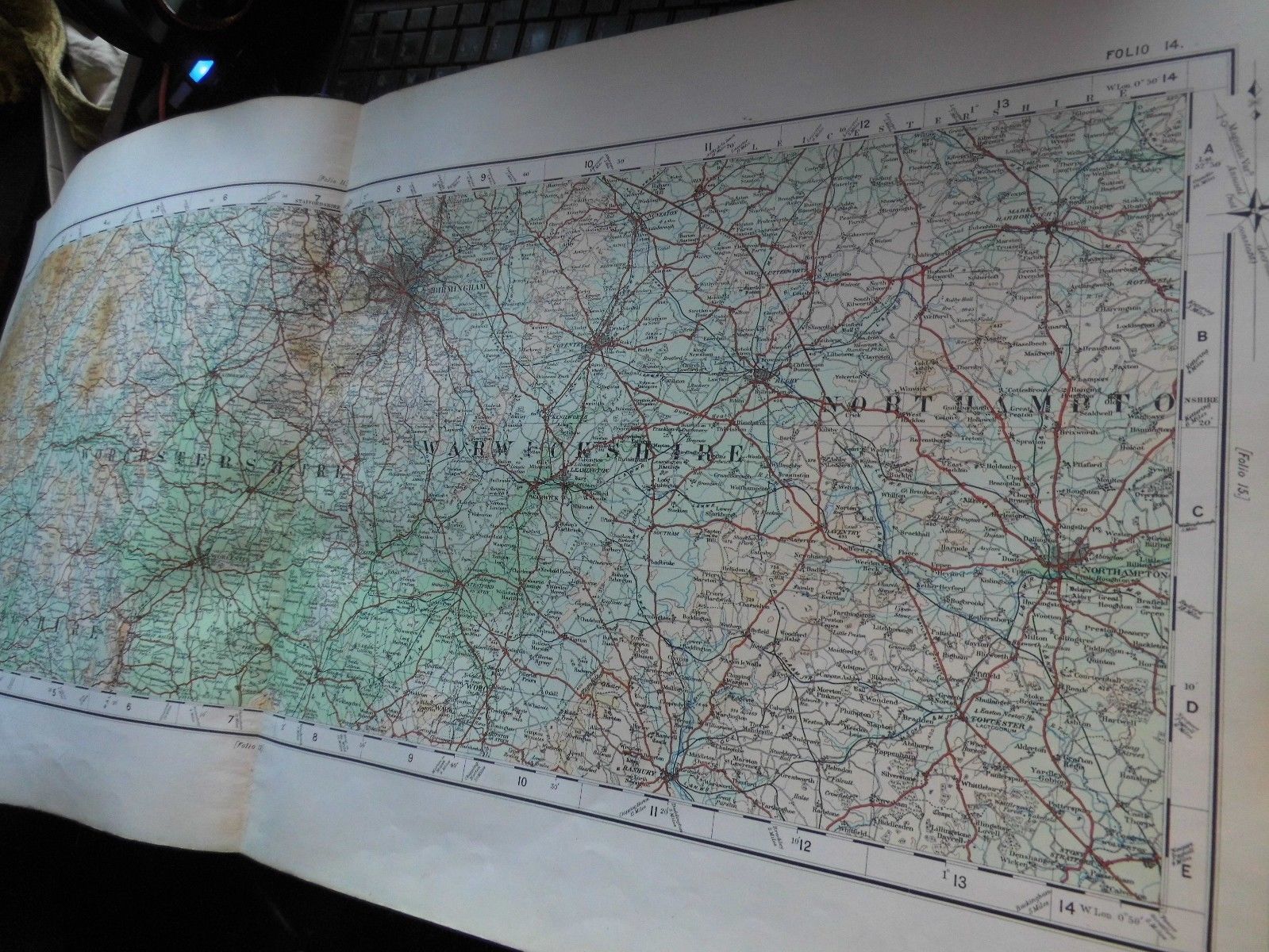
ARARE FOLIO MAP IN FULL TOPOGRAPHICAL COLOUR- BY THE ORDNANCE SURVEYTHEVERY SELDOM SEEN QUARTER INCH ELONGATED FOLIO SERIES OF1922FOLIO14RADNORSHIRETO NORTHAMPTONSHIRE, WORCESTERSHIREAND WARWICKSHIRE: ALL THECENTRAL MIDLANDS
.................GENERALNOTES ABOUT THIS UNUSUAL BESPOKE 1/4” ELONG...ATED SURVEY OF 1922
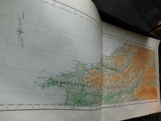
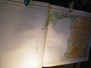
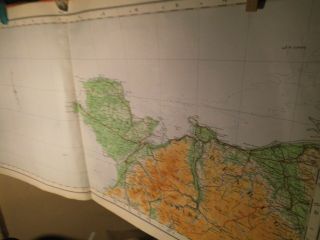
GENERALThismap is one of a fine survey of elongated maps mounted on bestlinen in full colour. The found frontispiece tells that they wereprinted in 1922 in the reign of George V and the full survey had 24very long maps: They covered all England Wales and the Isle of Manwith map 1 being in the far North Berwick, and map 24 being in thesouth west: Lands End, Scilly Isles to Torquay. Thus, map 1 wouldhave included large tracts of the Scottish borders as far west asDumfries and Lanark.Thisunusual survey was printed very methodically- thus occasionally asheet had a much smaller amount of land than sea: Folio 5 is anexample of this showing Lancaster and Preston in the east and theIrish Sea out to the southern tip of the Isle of Man in the west.
In1922 the A and B road system of the MOT was not established and thesemaps do not cite road numbers: driveable roads are tertiary red, allothers are uncoloured.TheColour Contour mapping is sometimes called Topographical Colouring, sometime “Orographic Colour” and sometimes “Coloured inLayers”. It is the manner famously preferred by Bartholomew but ishere seen in the OS form range from Apple Green ( 1-200ft) throughpale green, light ochre, and progressively darker through 5 othershaded to 2000 ft and above. That is not the usual OS range: theytended to use just ochres and umber on their tour maps, leaving greenfor woodland.Thesemaps also show: Railways, Stations, Tramways and Industrial Railways, Boundaries of Counties, Battle Sites, Windmills, Lighthouses, Light-Ships, Aerodromes (post Great War, pre 2nd War), Rivers and Contours both terrestrial and submarine.TheRailway companies are named in initials: LYR, NER, NBR, CR, GWR, S&DJR, SER, LB&SCR. Etc. So they are the old companies beforethe advent of the SR, LM&SR, GWR and L&NER.Themost interesting aspect of this map must be the elongated east westform. They present a novel swathe of the country roughly 100 mileseast west and 40 miles north south: it shows forms and geologicalrelationships between massifs, plains, littorals which are veryseldom seen.Theborders are marked in degrees and minutes and a grid is drawn , numbered and lettered on the border. The grid is 2 inches and thusrepresents 8 miles by 8 miles.Themap has good margins but unusually no printing on those margins. Thelinen back is much finer than that seen on a commercial folded map incovers. The high points are cited in feet and I assume in 1922 thedatum would be LMMT Liverpool, not the later Newlyn Datum.Theentire sheet measures 28 inches by 13 3/4 inchesFellmassifs are named, as are major dales, rivers, Roman roads andsummits.Ibelieve that this survey was only published in a limited folio form, which is why these maps almost never come to light. They wouldprobably have been bought by large reference libraries, orUniversities: leather bound. Probably bespoke (produced only to aspecific order by an institution.Thisis one of a few examples discovered and with this small group came afrontispiece from which I establish the nature of that 1922production. The former binding and covers were not found.Thissmall group of maps came to light in West Kent.
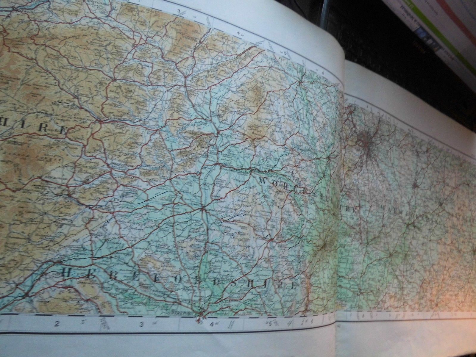
Hereis a section across the Midlands from the Radnorshire on the Welsh border, acrossthe Severn in the vicinity of Worcester, through Birmingham toNottingham with Watling Street nearing the south east of the maprunning to London.Againon such an unusually perspective it is relative position that mightsurprise. There is no River Trent on this map: that is altogether morenortherly. Nottingham in the East Midlands is on the same latitude asSt Davids. Banbury and Hereford are on the same latitude and both arenorth of the main Welsh coal mining valleys. Birmingham is on thelatitude of Aberystwyth to the west but only Cambridgeshire to theeast.Thereis a tendency for one to exaggerate the latitudes in the west andunderestimate them in the east.
Thetopographical colour gives a very good geological overview. There isa large flat basin south of Birmingham with the Vale of Evesham tothe east and the Severn Valley to the west. And land has not risenabove 200 ft even as far up as Bridgnorth or as far north east asLeamington.Birmingham, by contrast is set on a plateau with 1056 ft seen near Halesowen and876 ft seen at Oldbury near Smethwick. TheJurassic Hills of oolithic limestone run right up through this mapheading north eat to Market Harborough. These are the Cotswold Hillswhich have their south western end near Bath and some north easternremnant as far north as the Humber. They geologically divide England:Cretaceous and younger to the south and east: Older to the north andwest. A bit like the Tees Exe Line but expressing geological time.All the chalk of England is, therefore south and east of this line.
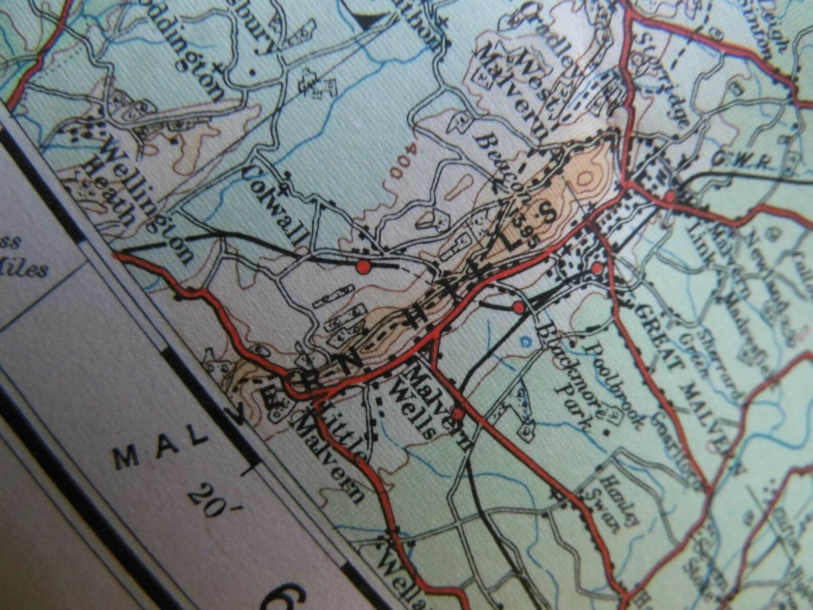
Birminghamis on a division between Permian and Triassic rocks- sandstones tothe west with mudstones to the east- then both those are sandwichedbetween late Westphalian types- this is late carboniferous and coalbearing. That is also what the hills are north of Coventry, but on thenorth east edge they run up against much older Ordovician rocks ofthe Cambrian age.Thenlooking west, the River Seven roughly divides the Devonian rocks on its westside from the Triassic mudstones on its east side but right in thesouth of the map are very close strata of rocks with igneous orvolcanic intrusions in the Malvern Hills.Heretoo, where Hereford meets Worcestershire, is an interesting culturalbarrier. To the west, one is in the Welsh Marches, and until recently Welshcould be heard in border Hereford towns and a wall runs along theMalvern Hills- one of several parallel series of dykes which show afluctuating meeting of various peoples: Britons, Romans, Siluriansand other tribes, M ercians and Welsh, Normans and the Welshprincipalities. It is interesting that all these dykes, The ShireDyke, Wat’s Dyke, Offa’s Dyke, seem to have been built to protect England or theEast from Wales or the West. Something is amiss between the archaeological evidence and the perceived history of England and this region.Alsothese Marcher Lordships of the west of the map were largely run by Breton (after the Conquest) and one wonders what their allegiance was; to the Welsh?, to theNormans? to other Bretons or the Church? or to nobody? Perhaps these people, such as the Fitz Baderons who governed Monmouth- had some cultural links with both communities east and west. Perhaps there was politics at work here with these imported barons controlling the western borders of the realm but being "deniable" by the crown if they acted badly. Heretoo in the west of the map is a “Watling Street” running northfrom Hereford to Shrewsbury. But that cannot be the same WatlingStreet as is named in the south east: so is that just a generic termfor any Roman Road?
BIRMINGHAMThisis a curious site and a curious position. It sits between watersheds: The River Weaver to the north west; the Severn to the west; Trent to the northeast; Avon to the south; but is itself almost devoid of naturally flowing water. It is served by canals- but it is interesting tospeculate how one gets canals onto this 800 ft plateau when the watersource for them must have been so limited. Perhapsit is exactly because it had some access north south east an west, that Birmingham grew. It also had iron ore and coal locally- and perhapsinitially charcoal from Arden, which seems to be a forest mentionedby Shakespeare but all but invisible on this or any other map- except in a coupleof place names- a shadow of a place- like Rheged and Elmet.IcknieldStreet runs south from Birmingham on this map: but again that cannotbe the Icknield Way of the Chilterns from the Wash to the Solent: itseems also to be being used as a generic term: perhaps in this caseindicating “Pre Roman”.
RIVERSTheSevern is a Welsh River to Welshpool and then an English River to itsEstuary at Tintern after which its tidal waters are shared. It riseson Plynlymon (Pumlumon) as do many other rivers including the Wye andthe Rheidol. It is met by the Avon at Tewkesbury and another atAvonmouth. There are many Avons- as far east as the Hampshire Border- but interesting none east of there. Many Roman roads mark theboundaries of catchment areas. Roman Roads were planned to run instraight lines but to avoid river crossings. But also sacred springs Nemeton were important places on them: or their clean water. Thusthe Avon can be defined as that river which runs west from whereFoss Way and Watling Street meet; where as the Thames and Cherwellrun south east from the Foss Way. The streams of the north west mustrun to the Ouse and thence to the Wash between Lincolnshire and NorfolkIfyou had to pick one spot as pivotal to the watersheds of the Midlandsand South; it would probably be Claybrook an insignificant villagewhere the Foss Way and Watling Street meet and were the Roman stationof Parva Bennones stood.Perhapsalso the Foss Way is as good a line as any at dividing the WestMidlands from the East Midlands.RAILWAYSHere, on this map, 1922 is the year before the amalgamation of the railwaysinto four big companies, which itself endured until British Railwayswas instigated in 1948-49.
The railway line west to Brecon is the Midland Railway with the Herefordshirerailways being operated jointly by the GWR and the L&NWR. Inthe Severn Valley the GWR and MR meet but do not share. Birmingham ismainly served by the LNWR and the MR.Thereis an interesting small grouping in the south east of the map wherethe Stratford Upon Avon and Midland Joint Railway runs several linesbetween Stratford and Towcester.Anothercompany which just makes and appearance in the north east of the mapis the Great Northern Railway, sharing lines with the L&NWR near MarketHarborough.
OLDAND NEW ROADSOnthis map which seems to coincidentally show the centre of the Roman road network, it isinteresting to note which are of those ancient highways were still used as major roads in 1922 andwhich are abandoned. Generally they were still in use. The greatexception is the Foss Way for the 32 miles between Halford andSapcote. It is interesting that if Roman engineers wanted to buildstraight roads an avoid wetlands, and the 19th centuryrailway engineers had exactly the same practical considerations: thenwhy do their routes almost never coincide? On reason might be thatthe Roman Roads connected ports. The early railways connected minesto canal basins. Romanroads are abandoned because the roads of the mediaeval age serveddroving and markets. Drove roads seek out water; market roads connectthe small local towns: Roman roads needed to do neither of thosethings.This1922 map is entirely prior to the idea of the by-pass or themotorway. A journey from Northampton to Knighton across this map is aroute through countless small town centres.
AVERY FINE, VERY UNUSUAL- ELONGATEDWEST-EASTPERSPECTIVE ON ENGLAND AND WALES.Knightonand Radnorshire to NorthamptonAn interesting section through the Midlands from West to East
MAPSTATS:TITLE: THEQUARTER INCHMAP OF ENGLAND FOLIO 14: RADNORSHIRE, HEREFORDSHIRE, WORCESTERSHIRE, WARWICKSHIRE, NORTHAMPTONSHIREDATES: 1922 PUBLISHER: THEORDNANCE SURVEY EDITION: 1/4FOLIO IN 24 MAPS- BESPOKE PRINTER: OrdnanceSurvey old England and Wales Office Southampton PRINTINGCODE: NOTSEENPRINTINGPROCESS: FULLCOLOUR LITHOGRAPHY WITH SOME LETTERPRESS IS BEST GUESS SCALE: 1/4 INCHTO THE MILE GRID: an8 mile grid, lettered and numbered OVERALLDIMENSIONS: 28 1/2 inchesby 13 1/4 inches, a very unusual formal COVERDIMENSIONS: nocover COVERDETAIL: nocover COVERCONDITION: nocover MAPPAPER OR LINEN BACKED: onbest linen FOLDWEAR: minor on single centre fold PINHOLES AT FOLD JUNCTIONS: no VERSO:plain linen FOXING:no REINFORCING: no SURFACEMARKING: light:evidence of a former binding tad horizontally on the plain linenverso- centre FOLDEDINTO: 2 atone time but now rolled not folded ANNOTATION: noneseen INTEREST:considerable: a bespoke folio map of the 1/4 inchtopographically coloured survey probably produced for reference onlyand not sold to general public: very unusual perspective of Britishlandscape seen in 100 mile by 40 mile strip.Here:from the Welsh Marches to the East Midlands, a most unusual viewGENERALCONDITION: good THENORTH WEST OF THIS MAP IS AT: Llanllwchaiarnnear Newtown.THENORTH EAST OF THIS MAP IS AT: BlastonTHESOUTH EAST OF THIS MAP IS AT: StonyStratfordTHESOUTH WEST OF THIS MAP IS AT: CrickadarnTHECENTRE OF THIS MAP IS AT: StokePriorXXXXXXXXXX