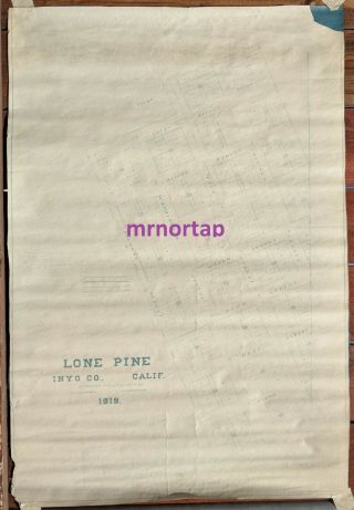
1914 Lone Pine Inyo CA Sherwin Survey Map Owens Valley Paiute Reservation


Item History & Price

Information:
Reference Number: Avaluer:14271138Format: Sheet Map
Printing Technique: Manuscript/Hand drawnType: Survey Map
US State: CaliforniaOriginal/Reproduction: Vintage Original
Country/Region: United States of AmericaDate Range: 1910-1919
Original Description:
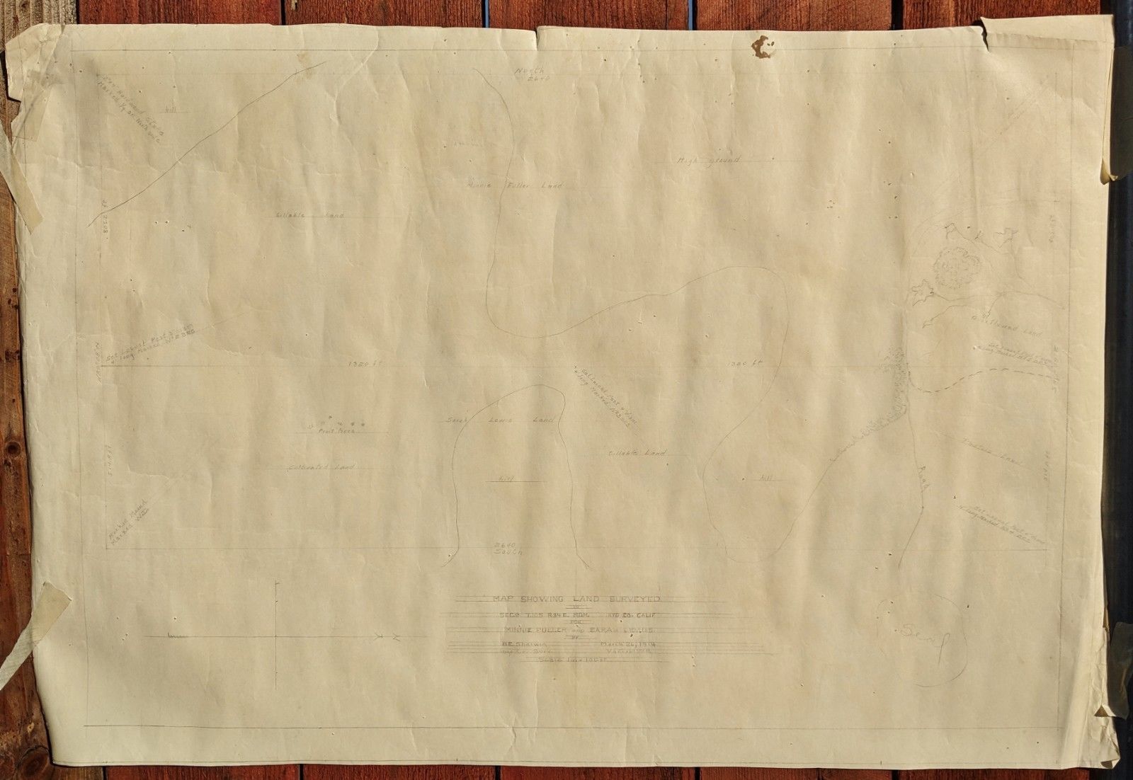
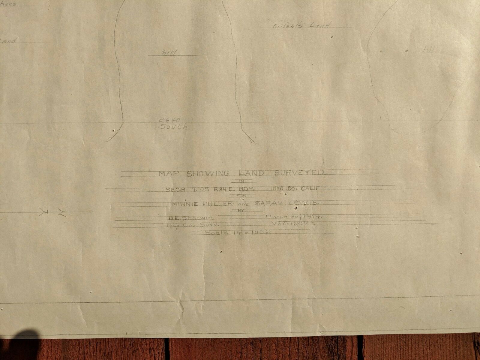
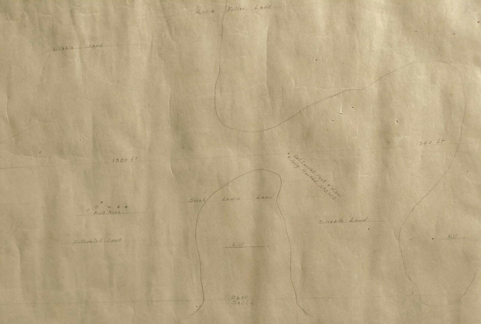
Interesting map showing land surveyed in SEC.9 T.105 R34E M.D.M, Inyo Co. Calif. for Minnie Fuller and Sarah Lewis.
Minnie Fuller and Sarah Lewis were linked to the Joe Dehy Ranch and both were indicted for murder in 1918 on the land surveyed here.

Original pencil hand drawn map surveyed by B. E. Sherwin in March 1914, approx. 31" x 21", very good condition w/ edge tears, map is sharper than in photos.
*******Pictures reflect exact product shipped. See pics for detail...s and feel free to request more. No items have been altered or repaired. Payment due within 3 days from sale day. Buyers outside the U. S. are responsible for custom fees. Check and agree with shipping & handling fees before bidding. Feel free to contact me for further info. Thank you for your visit.


    Similar items


  • 1919 Blue Print Map Of The Town Of Lone Pine Inyo Co California

    1919 Blue Print Map Of The Town Of Lone Pine Inyo Co California

  • Rare 1940

    Rare 1940 ' S Pyro Pint Milk Bottle Lone Pine Dairy Farm, Lone Pine, Inyo Co Ca

  • 1914 Annual Report Us Coast Geodetic Survey Maps Of Hawaii Alaska Philippines Pr

    1914 Annual Report Us Coast Geodetic Survey Maps Of Hawaii Alaska Philippines Pr

  • 1940s Dick

    1940s Dick ' S Farm House Fine Foods R. S. Dick Hiter Phone Lone Pine Olancha Ca

  • Geology Of The Independence Quadrangle Inyo Ca Geological Survey Bulletin 1181 - O

    Geology Of The Independence Quadrangle Inyo Ca Geological Survey Bulletin 1181 - O

  • Jawbone - Sunset On The Lone Pine Inyo Mojave - Owenyo Branch.

    Jawbone - Sunset On The Lone Pine Inyo Mojave - Owenyo Branch.

  • Rppc High Sierra Peaks Inc Mt Whitney As Seen From Lone Pine Cliff Ca - Frashers

    Rppc High Sierra Peaks Inc Mt Whitney As Seen From Lone Pine Cliff Ca - Frashers

  • Early Lone Pine Inyo Co Cal Ad Cover To L.  A.

    Early Lone Pine Inyo Co Cal Ad Cover To L. A.


    • You might also like


    • 1860 Mitchell Hand Colored Map Colorado,  Nebraska & Kansas - Civil War Era

      1860 Mitchell Hand Colored Map Colorado, Nebraska & Kansas - Civil War Era

    • 18th Century French Map Of North America

      18th Century French Map Of North America

    • Las Vegas Nevada Vintage 1967 Us Geological Survey Quadrangle Map 4 Panels

      Las Vegas Nevada Vintage 1967 Us Geological Survey Quadrangle Map 4 Panels

    • Rare Antique 1845 Maps United States Exploring Expedition Book Antartica Hawaii

      Rare Antique 1845 Maps United States Exploring Expedition Book Antartica Hawaii

    • Vintage 1926 Map Hollywood From The Best Surveys Of The Time

      Vintage 1926 Map Hollywood From The Best Surveys Of The Time

    • American Continent (western Hemisphere) 1747 Bowen Antique Copper Engraved Map

      American Continent (western Hemisphere) 1747 Bowen Antique Copper Engraved Map

    • Gulf Coast Florida Texas United States 1705 De Fer Unusual Antique Engraved Map

      Gulf Coast Florida Texas United States 1705 De Fer Unusual Antique Engraved Map

    • California As Island United States 1700 De Fer Unusual First Edition Antique Map

      California As Island United States 1700 De Fer Unusual First Edition Antique Map

Avaluer          About Us          Privacy Policy          Contact Us          UP
© 2022, avaluer.net, Inc. or its affiliates