Mitchell ' S General Atlas 1880 Turkey Berlin Congress Treaty Map


Item History & Price

Information:
Reference Number: Avaluer:14276179Year: 1880
Type: Political MapFormat: Atlas
Country/Region: Turkey
Original Description:
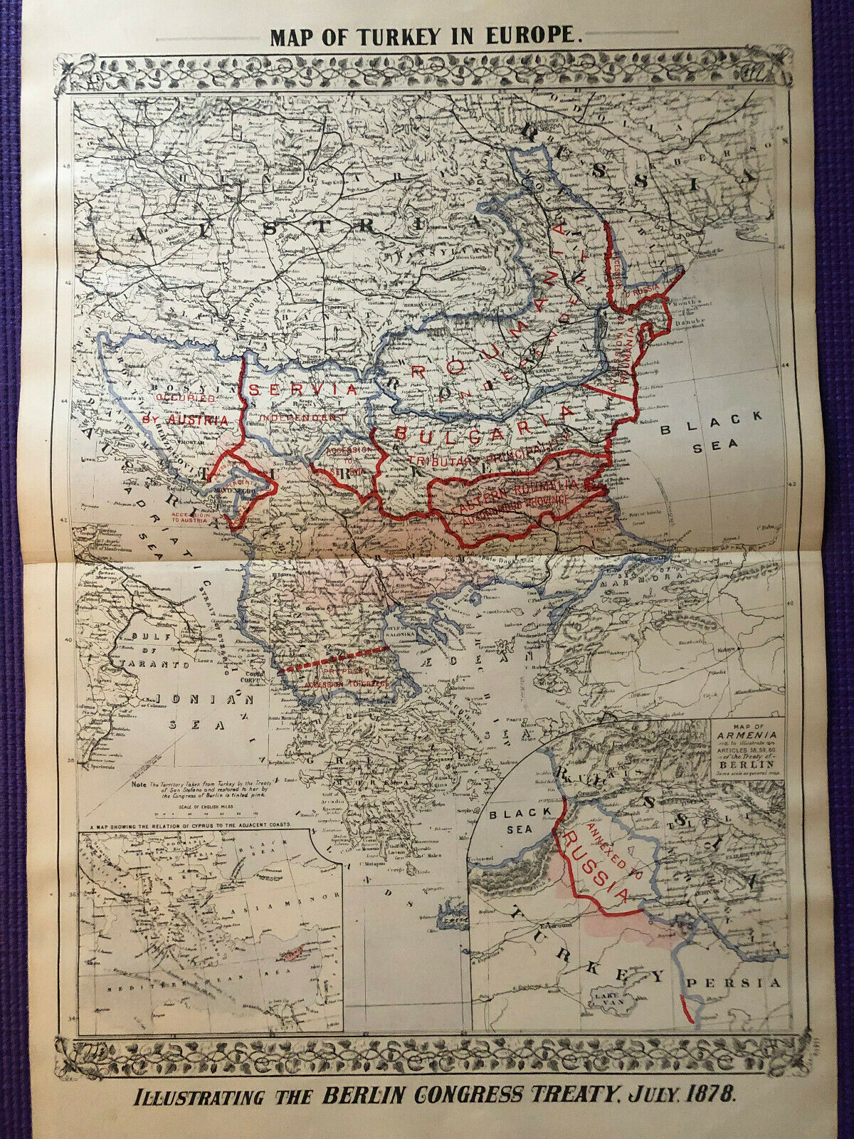
Mitchell's New General Atlas 1880 Turkey Map. Beautiful hand-colored 23 1/4 x 15 1/8 inch Political Map of Turkey with 1/2 inch margins on right border. Overall good condition, no tears, typical age coloring. Page 114 1/2 of Mitchell's Atlas.

Shipped with USPS Priority Mail, will be safely rolled and packaged in tube.


    Similar items


  • Mitchell

    Mitchell ' S General Atlas 1880 York Brooklyn Antique Plan

  • Mitchell

    Mitchell ' S General Atlas 1880 Texas Antique Map

  • Mitchell

    Mitchell ' S General Atlas 1880 Chicago Antique Plan

  • Mitchell

    Mitchell ' S General Atlas 1880 Philadelphia Antique Plan

  • Mitchell

    Mitchell ' S General Atlas 1880 City Of Boston Antique Plan

  • Mitchell

    Mitchell ' S General Atlas 1880 Antique Territory Of Dakota Map

  • Mitchell

    Mitchell ' S General Atlas 1880 Antique Plan Of Orleans

  • Mitchell

    Mitchell ' S General Atlas 1880 Antique " Indian Territory " Oklahoma Map


    • You might also like


    • Hungary & Romania 1579 (1584) Ortelius Unusual Antique Copper Engraved Map

      Hungary & Romania 1579 (1584) Ortelius Unusual Antique Copper Engraved Map

    • Brussels Bruxelles Belfium 1777 De Ferraris & Dupuis Large Antique Map Sheet Xxi

      Brussels Bruxelles Belfium 1777 De Ferraris & Dupuis Large Antique Map Sheet Xxi

    • 1616 Atlas Map Of Iceland.

      1616 Atlas Map Of Iceland.

    • Kazan Russia 1767 Le Clerc/lespinasse Antique Copper Engraved City View

      Kazan Russia 1767 Le Clerc/lespinasse Antique Copper Engraved City View

    • 1899 Stanford,  Folding Map Of Norwich,  Norfolk,  Arthur Collins,  Jarrold & Sons,

      1899 Stanford, Folding Map Of Norwich, Norfolk, Arthur Collins, Jarrold & Sons,

    • 1948 Vintage Linen Colour Map Geological Survey Ten Mile Of Great Britain

      1948 Vintage Linen Colour Map Geological Survey Ten Mile Of Great Britain

    • 1944 Map Flying Bombs Sussex Ww2 Newspaper Military Kent Courier German V1 V2

      1944 Map Flying Bombs Sussex Ww2 Newspaper Military Kent Courier German V1 V2

    • Dated 1638 Vellum Map Of Icklesham Sussex Showing Land Uses Owners Etc

      Dated 1638 Vellum Map Of Icklesham Sussex Showing Land Uses Owners Etc

Avaluer          About Us          Privacy Policy          Contact Us          UP
© 2022, avaluer.net, Inc. or its affiliates