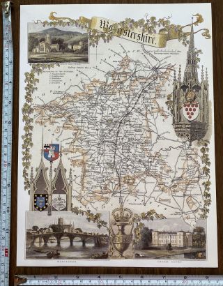
ANTIQUE TAPESTRY MAP WORCESTERSHIRE 1590 OLD ENGLISH NAMES IMAGE MOUNTED
Item History & Price
| Reference Number: Avaluer:14281906 | Type: Topographical Map |
| Country/Region: France |
SELLING HERE A FASCINATING HISTORICAL HARDBACK MAP
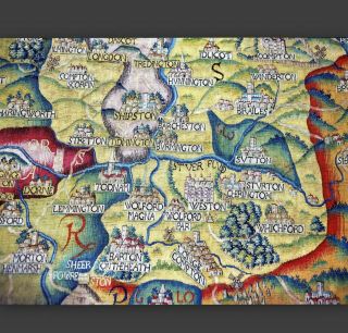
A TAPESTRY MAP OF WORCESTERSHIRE MADE DURING THE REIGN OF ELIZABETH 1.
A MAGNIFICENT REPLICA PRINT (NOT TAPESTRY) OF THE ORIGINAL MAP MADE AND PRODUCED FIFTEEN YEARS AGO IN LONDON PROFESSIONALLY MOUNTED BUT NOT FRAMED
ABOUT THIS MAP
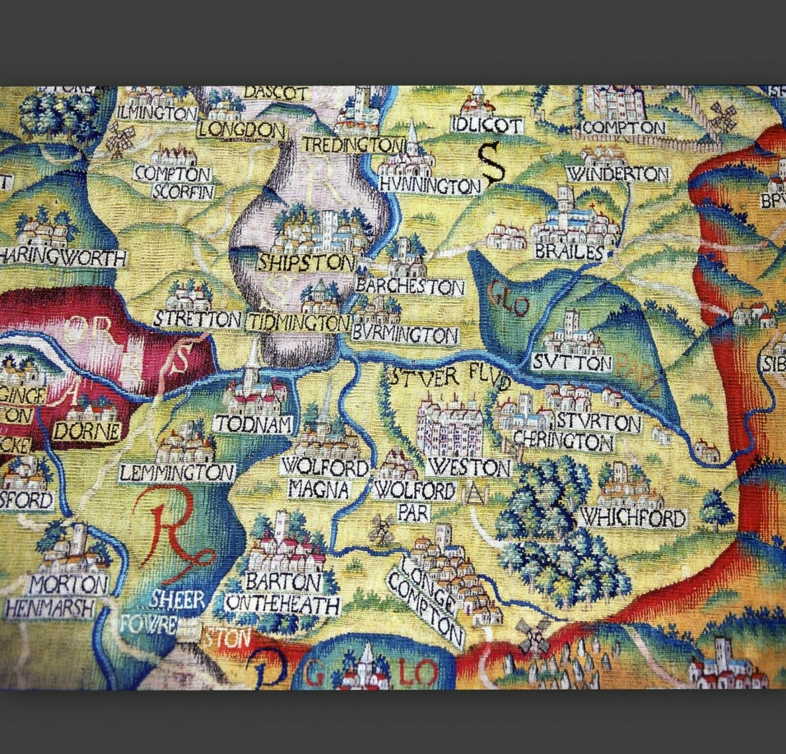
IN ENGLAND EXQUISITE and enormously expensive tapestries often played the same role that wall paintings did in warmer climes. In the 1590s, borrowing the idea of the wall map... to achieve a unique decorative scheme for 'his new house, Ralph Sheldon commissioned four woven tapestry maps showing the counties in which he lived, owned land and had friends and family — Warwickshire, Worcestershire, Oxfordshire and Gloucestershire. Each tapestry measured approximately 4 metres (20 feet) high and 6 metres (13 feet) wide; together, they formed a panoramic view across England from London to the Bristol Channel. The unknown designer composed his picture from information on the recent, and first, attempt at country-wide mapping, Christopher Saxton's county surveys. In this detailed view of Sheldon's home ground on the Warwickshire/Oxfordshire border, he may also have had local help. Separate colours demarcated the counties, four of which meet here. Hills, always emphasized with a green edge, became gently rounded or exaggeratedly conical to indicate change of terrain. Trees in more open country, as here, were short and squat, but in heavily wooded areas might be taller than the church towers or spires, illustrated without exactitude, which dominated the houses of the named villages. Bridges, differentiated between stone and wood, crossed rivers, some of them omitted from Saxton's maps. Palings and parkland surrounded the larger houses of gentlemen, including Sheldon's own at Weston, and those of many of his friends, depicted with at least an attempt at accuracy. Towns too, often shown in the conventional bird's-eye view from the south, were based on reality not imagination. However, the tapestry designer improved on his model; he included roads which, in yellow, wander uncertainly across a landscape dotted with windmills —usually Sheldon's property — the occasional fire beacon, or special landmarks such as the boundary marker known as the Four-Shire Stone close to Morton Henmarsh (now Moreton in the Marsh), or the Rollright Stones by the windmill south of Long Compton. The corners emphasized Sheldon's patriotic loyalty to Elizabeth I, despite his own Catholicism. They showed the royal arms, a scale and dividers, the family arms and a long descriptive passage paraphrasing William Camden's recently published Britannia, the verbal equivalent of Saxton's maps. The wide decorative borders, filled with architectural and allegorical motifs, also showed globes, named the points of the compass and contained doggerel verse celebrating the county's natural attractions.
SIZE: 28 x 24 cm
CONDITION: Excellent condition perfectly preserved in the archives.This superb historical image was printed and published fifteen years ago when the history of cartography was being compiled and since been professionally mounted to afford protection.This would make a superb item for display in your home or office and makes an ideal gift. This fascinating antique Map, especially if suitably framed, would make a stunning and eye catching displayTMB129 I offer a full money back guarantee on my descriptions please bid with confidence
VISIT THE ARCHIVES SHOP TO SEE OTHER HISTORIC PICTURES AND MAPS
WORLDWIDE POST
THANK YOU FOR VISITING