Antique Map Of North America By Robert De Vaugondy 1750


Item History & Price

Information:
Reference Number: Avaluer:14300052Cartographer/Publisher: Didier Robert de Vaugondy
Year: 1750Printing Technique: Copper Plate
Date Range: 1700-1799Original/Reproduction: Antique Original
Country/Region: North America, United States, CanadaType: Topographical Map
Era: 1700s
Original Description:
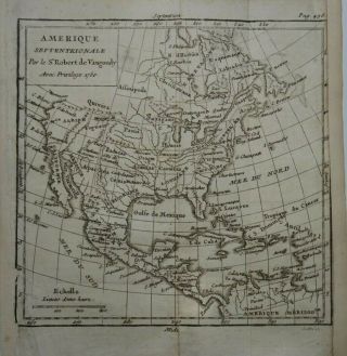
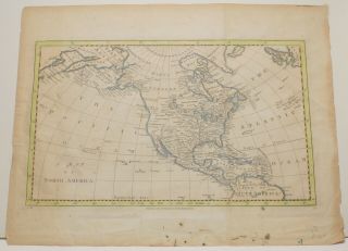
Map of North America by Didier Robert de Vaugondy 1750

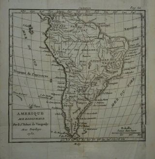
Copper engraved map on hand laid paper. Later hand colouring
Gilles Robert De Vaugondy (1688 - 1766) and Didier Robert De Vaugondy (1723 - 86) were descended from the cartographer and mapmaker Nicolas Sanson and they inherited much of his material.  They revised and corrected this material to produce their own maps. This map come from the 1751 edition of 'Geographie Universelle' by M. Crozat... published in Paris.
Page size is 16cm by 18cmMap area is in good condition for age, engravings are clear. Hand colouring.Blank on reverse.  Folds as issued.See photos for condition
All payments by paypal pleaseUK Postage freeWorldwide £5.00


    Similar items


  • Antique Map Of North America By Robert De Vaugondy 1750

    Antique Map Of North America By Robert De Vaugondy 1750

  • Antique Map Of South America By Robert De Vaugondy 1750

    Antique Map Of South America By Robert De Vaugondy 1750

  • Antique Map Of North America By William & Robert Chambers 1845

    Antique Map Of North America By William & Robert Chambers 1845

  • C1850 Antique Map Of North America By Tallis & Rapkin Hand - Colored Map

    C1850 Antique Map Of North America By Tallis & Rapkin Hand - Colored Map

  • C1850 Antique Map Of North America By Tallis & Rapkin Hand - Colored Map

    C1850 Antique Map Of North America By Tallis & Rapkin Hand - Colored Map

  • Antique Map Of North America By Charles Cooke 1700`s Rare

    Antique Map Of North America By Charles Cooke 1700`s Rare

  • Antique Map Of Spain & Portugal By Robert De Vaugondy 1750

    Antique Map Of Spain & Portugal By Robert De Vaugondy 1750

  • Antique Map Of North America By James Barlow 1806

    Antique Map Of North America By James Barlow 1806


    • You might also like


    • Hungary & Romania 1579 (1584) Ortelius Unusual Antique Copper Engraved Map

      Hungary & Romania 1579 (1584) Ortelius Unusual Antique Copper Engraved Map

    • Brussels Bruxelles Belfium 1777 De Ferraris & Dupuis Large Antique Map Sheet Xxi

      Brussels Bruxelles Belfium 1777 De Ferraris & Dupuis Large Antique Map Sheet Xxi

    • 1616 Atlas Map Of Iceland.

      1616 Atlas Map Of Iceland.

    • Kazan Russia 1767 Le Clerc/lespinasse Antique Copper Engraved City View

      Kazan Russia 1767 Le Clerc/lespinasse Antique Copper Engraved City View

    • 1899 Stanford,  Folding Map Of Norwich,  Norfolk,  Arthur Collins,  Jarrold & Sons,

      1899 Stanford, Folding Map Of Norwich, Norfolk, Arthur Collins, Jarrold & Sons,

    • 1948 Vintage Linen Colour Map Geological Survey Ten Mile Of Great Britain

      1948 Vintage Linen Colour Map Geological Survey Ten Mile Of Great Britain

    • 1944 Map Flying Bombs Sussex Ww2 Newspaper Military Kent Courier German V1 V2

      1944 Map Flying Bombs Sussex Ww2 Newspaper Military Kent Courier German V1 V2

    • Dated 1638 Vellum Map Of Icklesham Sussex Showing Land Uses Owners Etc

      Dated 1638 Vellum Map Of Icklesham Sussex Showing Land Uses Owners Etc

Avaluer          About Us          Privacy Policy          Contact Us          UP
© 2022, avaluer.net, Inc. or its affiliates