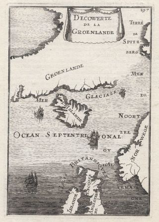
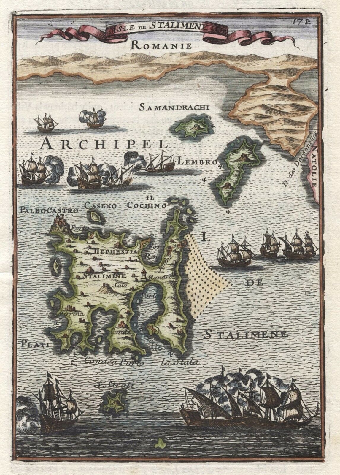
1683 Lemnos Limnos Hand Coloured 17th Century Copper Plate Engraved Map Mallet


Item History & Price

Information:
Reference Number: Avaluer:15680996Year: 1683
Date Range: 1600-1699Original/Reproduction: Antique Original
Printing Technique: Copper PlateFormat: Atlas Map
Era: 1700sCartographer/Publisher: Allain Manesson Mallet
Original Description:
GENUINE ANTIQUE COPPER PLATE MAP TAKEN FROMDescription de l'Univers contenant les différents Systèmes du Monde...by Allain Manesson MalletPublished 1683GENUINE ANTIQUE MAP. NOT A COPY. NOT A REPRODUCTION.Description/Condition:  image measures 15cm x 10cm with good margins beyond, French text verso, good condition - please refer to images and examine carefully.Perfectly suitable for framingGENUINE ANTIQUE MAP GUARANTEED OVER 300 YEARS OLDMONEY B...ACK GUARANTEE IF NOT COMPLETELY SATISFIEDPOSTAGE AT COST. WILL COMBINE POSTAGE FOR MULTIPLE PURCHASES - PLEASE ASK.If you have any questions, please ask. Thank you.m39


Track Page Views With
Auctiva's FREE Counter


    Similar items


  • 1683 Greenland Iceland Arctic Lands 17th Century Copper Plate Map Mallet

    1683 Greenland Iceland Arctic Lands 17th Century Copper Plate Map Mallet

  • Rare Hand Coloured 17th Century Map Of Tartary By John Speed

    Rare Hand Coloured 17th Century Map Of Tartary By John Speed

  • Rare Antique 17th Century Copper Relic Reliquary Brooch Hand Gauntlet Mourning

    Rare Antique 17th Century Copper Relic Reliquary Brooch Hand Gauntlet Mourning

  • 1858 Antique Map Of Australia Old Hand Coloured 19th Century Victorian

    1858 Antique Map Of Australia Old Hand Coloured 19th Century Victorian

  • Antique Map Of Spain Portugal Europe Old Hand Coloured 19th Century

    Antique Map Of Spain Portugal Europe Old Hand Coloured 19th Century

  • Antique Map Tuscany Papal States Italy Europe Old Hand Coloured 19th Century

    Antique Map Tuscany Papal States Italy Europe Old Hand Coloured 19th Century

  • Antique Map Of Barbados The Leeward Islands Trinidad Hand Coloured 19th Century

    Antique Map Of Barbados The Leeward Islands Trinidad Hand Coloured 19th Century

  • Antique Map Of Zealand South Island Middle Old Hand Coloured 19th Century

    Antique Map Of Zealand South Island Middle Old Hand Coloured 19th Century


    • You might also like


    • Hungary & Romania 1579 (1584) Ortelius Unusual Antique Copper Engraved Map

      Hungary & Romania 1579 (1584) Ortelius Unusual Antique Copper Engraved Map

    • Brussels Bruxelles Belfium 1777 De Ferraris & Dupuis Large Antique Map Sheet Xxi

      Brussels Bruxelles Belfium 1777 De Ferraris & Dupuis Large Antique Map Sheet Xxi

    • 1616 Atlas Map Of Iceland.

      1616 Atlas Map Of Iceland.

    • Kazan Russia 1767 Le Clerc/lespinasse Antique Copper Engraved City View

      Kazan Russia 1767 Le Clerc/lespinasse Antique Copper Engraved City View

    • 1899 Stanford,  Folding Map Of Norwich,  Norfolk,  Arthur Collins,  Jarrold & Sons,

      1899 Stanford, Folding Map Of Norwich, Norfolk, Arthur Collins, Jarrold & Sons,

    • 1948 Vintage Linen Colour Map Geological Survey Ten Mile Of Great Britain

      1948 Vintage Linen Colour Map Geological Survey Ten Mile Of Great Britain

    • 1944 Map Flying Bombs Sussex Ww2 Newspaper Military Kent Courier German V1 V2

      1944 Map Flying Bombs Sussex Ww2 Newspaper Military Kent Courier German V1 V2

    • Dated 1638 Vellum Map Of Icklesham Sussex Showing Land Uses Owners Etc

      Dated 1638 Vellum Map Of Icklesham Sussex Showing Land Uses Owners Etc

Avaluer          About Us          Privacy Policy          Contact Us          UP
© 2022, avaluer.net, Inc. or its affiliates