POLAND CA. 1550 ANTIQUE MAP LITHUANIA RUSSIA BELARUS UKRAINE MUNSTER
Item History & Price
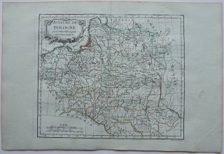
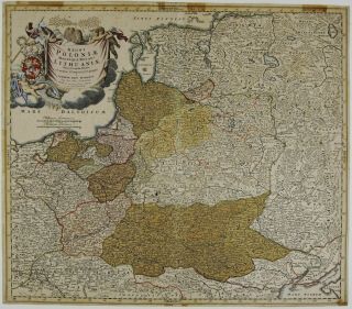
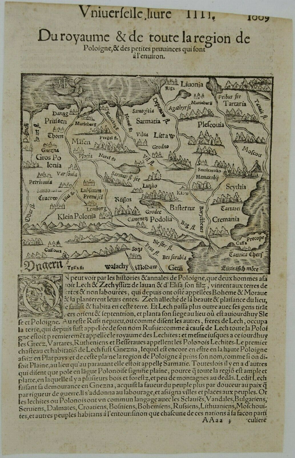
Title: “Du royaume & de toute la region de Poloigne & des petits provinces qui sont a l’enivron”
Description:Early map of Poland with a brief description extending from Posen and the Oder to Hungary, Walachy, Moldaw and the Black Sea, north to include Moscow and Latvia. Taken from a French edition of Sebastian Münster’s encyclopedic work, the “Cosmographia Universalis“. The Cosmographia by Sebastian Münster from 1544 is t...he earliest German description of the world.
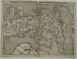
Cartographer: Sebastian Munster (1488 – 1552)Sheet size: 27, 0 x 17, 5 cmYear: ca. 1550Technique: woodcut Condition:Good condition. Strong print and paper, wide margins. Slight top margin trim.This is a genuine antique mappublished in ca. 1550 and NOT a modern copy or reprint! Due to the ageof this map some imperfections to be expected! Do not hesitate to ask for moreinformation! Combine shippingis possible! POLANDPOLONIA POLEN POLOGNE POLSKA POLSKI LITHUANIA LITAUEN LITUANIA LITHUANIA LITUANIE UKRAINE UKRAINA UKRANIA UKRANIAE BELARUS BELORUS WEISSRUSSLAND RUSSIA RUSSLANDOSTROLEKA PLONSK OSTROW WYSZKOW PRUSZKOW SOCHACZEW RUSSIE WARSAW WARSCHAU WARSZAWAVARSOVIE KRAKOW CRACOW KRAKAU GDANSK DANZIG KIEV KYIV KIOW MINSK WILNA VILNIUS VILNA WILNOLVIV LWOW LEOPOL LEMBERG BRESLAU WROCLAW TROKI TRAKAI KAUNAS KOWNO SAMOGITIA LUBLIN KAMIENEZ CZESTOCHOWASOSNOWIEC GRODNO HRODNA BREST KALISZ POZNAN RAVA RADOM KURLANDKIELCE GLIWICE RZESZOW COURLANDE LODZ SZCZECINSTETTIN POSEN BYDGOSZCZ BROMBERG THORN TORUN GDYNIA KATOWICE BIALYSTOK PULTUSK LIETUVA POLSKA
Description:Early map of Poland with a brief description extending from Posen and the Oder to Hungary, Walachy, Moldaw and the Black Sea, north to include Moscow and Latvia. Taken from a French edition of Sebastian Münster’s encyclopedic work, the “Cosmographia Universalis“. The Cosmographia by Sebastian Münster from 1544 is t...he earliest German description of the world.
Cartographer: Sebastian Munster (1488 – 1552)Sheet size: 27, 0 x 17, 5 cmYear: ca. 1550Technique: woodcut Condition:Good condition. Strong print and paper, wide margins. Slight top margin trim.This is a genuine antique mappublished in ca. 1550 and NOT a modern copy or reprint! Due to the ageof this map some imperfections to be expected! Do not hesitate to ask for moreinformation! Combine shippingis possible! POLANDPOLONIA POLEN POLOGNE POLSKA POLSKI LITHUANIA LITAUEN LITUANIA LITHUANIA LITUANIE UKRAINE UKRAINA UKRANIA UKRANIAE BELARUS BELORUS WEISSRUSSLAND RUSSIA RUSSLANDOSTROLEKA PLONSK OSTROW WYSZKOW PRUSZKOW SOCHACZEW RUSSIE WARSAW WARSCHAU WARSZAWAVARSOVIE KRAKOW CRACOW KRAKAU GDANSK DANZIG KIEV KYIV KIOW MINSK WILNA VILNIUS VILNA WILNOLVIV LWOW LEOPOL LEMBERG BRESLAU WROCLAW TROKI TRAKAI KAUNAS KOWNO SAMOGITIA LUBLIN KAMIENEZ CZESTOCHOWASOSNOWIEC GRODNO HRODNA BREST KALISZ POZNAN RAVA RADOM KURLANDKIELCE GLIWICE RZESZOW COURLANDE LODZ SZCZECINSTETTIN POSEN BYDGOSZCZ BROMBERG THORN TORUN GDYNIA KATOWICE BIALYSTOK PULTUSK LIETUVA POLSKA