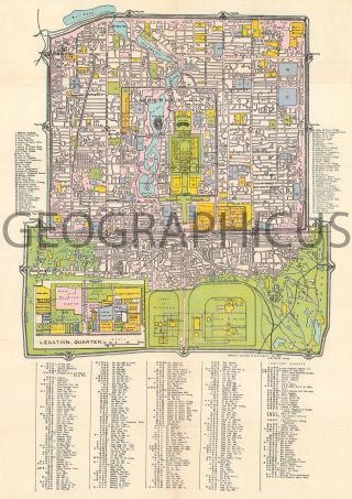
1890 Koke City Map Or Plan Of Vienna, Austria

Item History & Price
| Reference Number: Avaluer:16386 |
1890 Koke City Map or Plan of Vienna, Austria
WE SELL ONLY ORIGINAL ANTIQUE MAPS - NOT REPRODUCTIONS
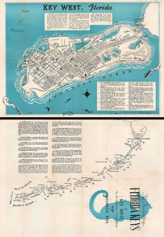
Title: Neuer Orientirungs-Plan von Wien mit allen Strassenbenennungen.
Description: This is an 1890 F. Köke city map or plan of Vienna, Austria. The map depicts the city from Währing and Neulerchenfeld to Leopoldstadt and Simmering and from Brigittenau to Favoriten. Each of the different cadastrals are numbered, labeled, and colored diff...erently for easy differentiation. Individual buildings are illustrated and several of the important locations throughout the city are labeled. Numerous streets are labeled, along with rail lines, bidges, and squares. The Danube River is situated in the upper right corner, with the Viennese Danube Canal cutting through town. An index of tramway signals is situated along the bottom border, indicating the line on which the tramway operates.
This map was produced by F. Köke in 1890.
Size: Printed area measures 19.5 inches high by 17.25 inches wide.
Condition: Very good. Light wear along original fold lines. Attached to original binder. Blank on verso.
Shipping: Shipping rates are not negotiable. Items are shipped within three business days of receiving payment. We are happy to consolidate shipping where possible. The following shipping options are available: 1. FedEx Overnight (45 USD). USA Only. Signature Required.
2. FedEx Ground or Home Delivery (15 USD). USA Only. 1 - 10 days. If your address is a P.O. Box and cannot ship FedEx we will ship USPS Priority and, while we ship promptly, recent postal personnel cutbacks mean that delivery may take time. Signature Required.
3. FedEx International or DHL International EXPRESS (45 USD).
4. We can use your FedEx Account.
Customs: International buyers are responsible for paying duty and taxes on delivery. DHL or FedEx will contact the buyer by telephone to arrange tax payment if it is levied. Duty varies by country and we cannot predict the amount you will be charged. Some countries are duty free, others are not. Typically, a customs duty and/or VAT tax will be assessed on all parcels to continental Europe. Sometimes duty or tax is due in China, but is seems very random. Hong Kong, Singapore, Korea, and Taiwan have never assessed duty on a map we shipped. Maps shipped to the UK should be duty free as educational materials, but from time to time duty of 5% is assessed incorrectly by the UK customs agents.
Insurance: All shipments are insured privately against loss and damage. All of our shipments require a signature for insurance purposes.
If you have any questions please feel free to email us through eBay.
Other ServicesConservation Framing: Geographicus recommends basic conservation framing services for any antique paper. We do not offer this service.
Antique Map Restoration: Geographicus can repair and restore your antique map. Services include deacidification cleaning flattening and backing.
BEWARE anyone attempting to contact you, from a different eBay account, claiming to represent Geographicus Antique Maps. My eBay handle is GeographicusMaps. If you are contacted by email by someone offering you my items, please call me directly to be certain you are not dealing with a con artist. "