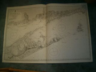
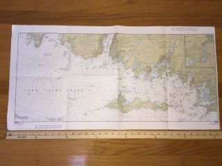
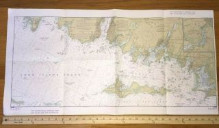
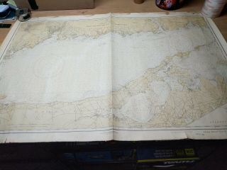
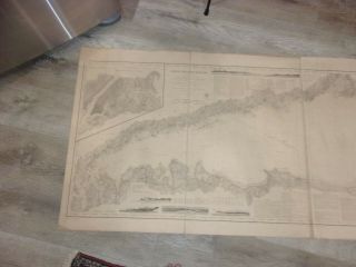
1919 LONG ISLAND SOUND EAST COAST U. S. GEODETIC SURVEY CHART CONN - N. Y.


Item History & Price

Information:
Reference Number: Avaluer:20057603Year: 1919
Publication Year: 1916Country/Region: United States of America
Country Of Manufacture: United StatesCity: New York Conneticut
Type: MapCountry Region: United States
Product: MapTopic: United States
Original Description:
1919 LONG ISLAND SOUND EAST COAST U.S.GEODETIC SURVEY CHART CONN - N.Y.
United States East Coast  Connecticut - New York..Marked 1919.Measures 32" x 43".Shows some wear, rips & stains..Great Framing Piece..Please See Photos.Thanks..


    Similar items


  • Vintage Admiralty Chart 2754 Usa - Long Island Sound (east Part) 1911 Edn

    Vintage Admiralty Chart 2754 Usa - Long Island Sound (east Part) 1911 Edn

  • Vintage Nautical Chart,  Long Island Sound & Ct Coast,  116 - Sc,  9th Edition,  1970

    Vintage Nautical Chart, Long Island Sound & Ct Coast, 116 - Sc, 9th Edition, 1970

  • Vintage Nautical Chart,  Long Island Sound & Ct Coast,  116 - Sc,  9th Edition,  1970

    Vintage Nautical Chart, Long Island Sound & Ct Coast, 116 - Sc, 9th Edition, 1970

  • Vintage Nautical Chart,  Long Island Sound & Ct Coast,  116 - Sc,  9th Edition,  1970

    Vintage Nautical Chart, Long Island Sound & Ct Coast, 116 - Sc, 9th Edition, 1970

  • Vintage Map C&gs 1213 Us East Coast Long Island Sound Eastern Part Dated 5/23/27

    Vintage Map C&gs 1213 Us East Coast Long Island Sound Eastern Part Dated 5/23/27

  • Maps Charts Survey Of Usa Coast U.  S.  C.  & G.  Long Island Sound

    Maps Charts Survey Of Usa Coast U. S. C. & G. Long Island Sound

  • U.  S.  S.  Paducah In Long Island Sound J L Wolfe Ship City Selected Jeweler Ny Ky

    U. S. S. Paducah In Long Island Sound J L Wolfe Ship City Selected Jeweler Ny Ky

  • U.  S.  S.  Texas At Anchor In Long Island Sound York Vintage Postcard An9

    U. S. S. Texas At Anchor In Long Island Sound York Vintage Postcard An9


    • You might also like


    • 1860 Mitchell Hand Colored Map Colorado,  Nebraska & Kansas - Civil War Era

      1860 Mitchell Hand Colored Map Colorado, Nebraska & Kansas - Civil War Era

    • 18th Century French Map Of North America

      18th Century French Map Of North America

    • Las Vegas Nevada Vintage 1967 Us Geological Survey Quadrangle Map 4 Panels

      Las Vegas Nevada Vintage 1967 Us Geological Survey Quadrangle Map 4 Panels

    • Rare Antique 1845 Maps United States Exploring Expedition Book Antartica Hawaii

      Rare Antique 1845 Maps United States Exploring Expedition Book Antartica Hawaii

    • Vintage 1926 Map Hollywood From The Best Surveys Of The Time

      Vintage 1926 Map Hollywood From The Best Surveys Of The Time

    • American Continent (western Hemisphere) 1747 Bowen Antique Copper Engraved Map

      American Continent (western Hemisphere) 1747 Bowen Antique Copper Engraved Map

    • Gulf Coast Florida Texas United States 1705 De Fer Unusual Antique Engraved Map

      Gulf Coast Florida Texas United States 1705 De Fer Unusual Antique Engraved Map

    • California As Island United States 1700 De Fer Unusual First Edition Antique Map

      California As Island United States 1700 De Fer Unusual First Edition Antique Map

Avaluer          About Us          Privacy Policy          Contact Us          UP
© 2022, avaluer.net, Inc. or its affiliates