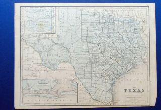
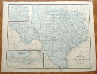
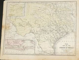
1852 Hand - Colored Mitchell Map Of Texas W/Indian Tribes


Item History & Price

Information:
Reference Number: Avaluer:20308001
Original Description:
An authentic, hand-colored, map of Texas from a dis-bound Mitchell's School and Family Geography book. Size = about 9" X 12." 
Every item I sell is guaranteed authentic. I never sell reproductions. Ever.
Shipping is $2.95 forthe first map and free for any additional. Maps are shipped in study mailing tubes to insure you receive the item you purchased in its advertised condition.If you have anyquestions feel free to ask. Thanks for looking. 

...


    Similar items


  • 1869 Hand - Colored Mitchell Map Of Texas,  Comanches

    1869 Hand - Colored Mitchell Map Of Texas, Comanches

  • 1852 Hand - Colored Mitchell Map Of North America/british America/russian America

    1852 Hand - Colored Mitchell Map Of North America/british America/russian America

  • 1852 Hand - Colored Mitchell Map United States And Gold Region Of California

    1852 Hand - Colored Mitchell Map United States And Gold Region Of California

  • 1860 Full Hand Colored Mitchell Map Of Austrian Empire,  Italian States,  Greece,  I

    1860 Full Hand Colored Mitchell Map Of Austrian Empire, Italian States, Greece, I

  • 1858 Hand - Colored Mitchell Map The State Of Texas W/galveston,  Kiowa Indians

    1858 Hand - Colored Mitchell Map The State Of Texas W/galveston, Kiowa Indians

  • 1852 Mitchell,  Map Of Texas,  No.  13 Map Of The State Of Texas - Framed

    1852 Mitchell, Map Of Texas, No. 13 Map Of The State Of Texas - Framed

  • 1847 Hand Colored Engraved Map Of Europe - Mitchell

    1847 Hand Colored Engraved Map Of Europe - Mitchell ' S Atlas

  • Antique American Map: Mexico,  Texas,  Guatemala,  W.  Indies - 1852 - Hand - Colored

    Antique American Map: Mexico, Texas, Guatemala, W. Indies - 1852 - Hand - Colored


    • You might also like


    • 1860 Mitchell Hand Colored Map Colorado,  Nebraska & Kansas - Civil War Era

      1860 Mitchell Hand Colored Map Colorado, Nebraska & Kansas - Civil War Era

    • 18th Century French Map Of North America

      18th Century French Map Of North America

    • Las Vegas Nevada Vintage 1967 Us Geological Survey Quadrangle Map 4 Panels

      Las Vegas Nevada Vintage 1967 Us Geological Survey Quadrangle Map 4 Panels

    • Rare Antique 1845 Maps United States Exploring Expedition Book Antartica Hawaii

      Rare Antique 1845 Maps United States Exploring Expedition Book Antartica Hawaii

    • Vintage 1926 Map Hollywood From The Best Surveys Of The Time

      Vintage 1926 Map Hollywood From The Best Surveys Of The Time

    • American Continent (western Hemisphere) 1747 Bowen Antique Copper Engraved Map

      American Continent (western Hemisphere) 1747 Bowen Antique Copper Engraved Map

    • Gulf Coast Florida Texas United States 1705 De Fer Unusual Antique Engraved Map

      Gulf Coast Florida Texas United States 1705 De Fer Unusual Antique Engraved Map

    • California As Island United States 1700 De Fer Unusual First Edition Antique Map

      California As Island United States 1700 De Fer Unusual First Edition Antique Map

Avaluer          About Us          Privacy Policy          Contact Us          UP
© 2022, avaluer.net, Inc. or its affiliates