1908 Sumas Washington Bellingham Rare Antique USGS Topographic Topo Map


Item History & Price
1908 SUMAS WASHINGTON ANTIQUE USGS TOPO MAP Vintage Cartographics Washington Maps ∙ Antique Prints ∙ Bargain Bin ∙ Browse Nearby Sheets 1908
Sumas
Washington
USGS TOPOGRAPHIC MAP
first-year print in very good condition
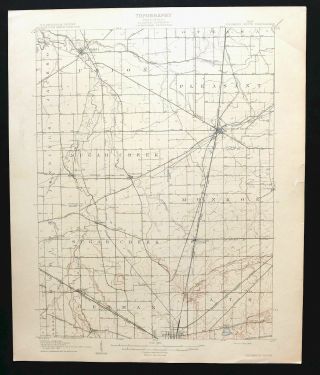
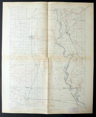
For sale is the 1908 edition of the Sumas 15-minute map. This map would be ideal for framing or display, historical ref...erence or research, genealogy studies, adding to your collection, treasure hunting, a nice conversation piece, a gift for a history or map enthusiast, or for anyone interested in this area. This sheet includes the only survey produced by the United States Geological Survey for the Sumas 15-minute quadrangle. The map is an original 1908 USGS print. This rare 111-year-old-year-old sheet is a first-year printing and is in very good condition. The Sumas 15-minute map shows all roads, paths, towns, railroads, rivers, creeks, elevation contour lines, public land survey lines, county, state, and other administrative boundaries as they existed at the time of the survey in 1906. All known structures (houses, businesses, churches, schools, barns, cabins, etc) are also shown, with exceptions in some urban areas, where only landmark buildings may be shown. The Sumas map was field surveyed before aerial photography methods were widely used in map data gathering. It was drawn by cartographers based on plane table field survey information as well as information gathered from local residents in the area. It displays the remarkable abilities of early government map makers, who placed a strong emphasis on creating complete, accurate, and cartographically appealing maps. Maps from the 15-minute series for the continental United States are no longer produced or printed by the USGS and original prints are becoming increasingly difficult to find. They are a valuable historical record for an area, as they contain many placenames and features that have been dropped from more recent maps. MAP DETAILS Title Sumas State Washington Series 15-minute Surveyed 1906 Field Survey Geographer E.M. Douglas Engraved 1908 Edition 1908 Printed 1908, thick paper stock Woodland Tint No Scale 1:62500 Contour Interval 20 Foot Sheet Dimensions 16 1/2 x 20 inches (approximate) Map Dimensions 11 1/2 x 17 1/2 inches Coverage Area 11 x 17 miles SHEET CONDITION For maps of this vintage, effort is made to note all visible flaws, no matter how minor. Overall Condition VERY GOOD Sheet Notes lightly handled, midsheet horizontal and vertical foldlines, subtle age-toning along fold lines Map Area no markings, no blemishes, pinhole separation at fold line intersection Collar Area no wear, very minor blemishes, small inventory notation in upper right collar corner, inventory stamp on lower collar MAP COVERAGE Quadrangle extent overlaid on current basemap. Browse Nearby
Sheets PLACENAMES Depending on map series and survey date, all of the features listed below may not be shown on this map. This list contains features that currently exist or historically existed within the area covered by this map. The list can be used as a reference to determine if this map covers your area of interest. Placenames are listed alphabetically next to each feature type. Cities and Towns (current) Acme, Bellingham, Deming, Everson, Geneva, Lynden, Nooksack, Strandell, and Sumas Counties Covered Whatcom Rivers and Streams Anderson Creek, Bone Creek, Breckenridge Creek, Carpenter Creek, Dale Creek, Deer Creek, Fishtrap Creek, Fourmile Creek, Johnson Creek, Kinney Creek, Macaulay Creek, Nooksack River, Olsen Creek, Pepin Creek, Silver Creek, Smith Creek, Squalicum Creek, Squaw Creek, Sumas River, Swift Creek, Sygitowicz Creek, Tenmile Creek, and Whatcom Creek Water Bodies Lake Fazon, Fountain Lake, Green Lake, Judson Lake, Lake Whatcom, Squalicum Lake, Toad Lake, and Wiser Lake Populated Places: Agate Bay, Bellingham, Cedarville, Clearbrook, Dewey, Eureka, Everson, Goshen, Greenwood, Hampton, Larson Mill, Laurel, Lawrence, Lynden, Nooksack, Noon, Northwood, Nugents Corner, Roosevelt, Silver Beach, Strandell, Van Wyck, Victor, and Wahl. Locations: Bartlett Beach, Bellingham Country Club, Bellis Fair Mall, Cordata Place, Dutch Village Mall, Haggen Shopping Center, Laurel Gardens, Meridian Village, Northwest Center, Park Manor Shopping Center, Tenmile, and Tenmile Grange. Mountains, Peaks, and Summits: King Mountain, Squalicum Mountain, Stewart Mountain, and Toad Mountain. Parks: Battersby Field, Bloede Donovan Park, Broadway Park, Elizabeth Park, Roosevelt Field, Saint Clair Park, and Whatcom Falls Park. Drainages: Anderson Creek, Breckenridge Creek, Bone Creek, Carpenter Creek, Dale Creek, Fourmile Creek, Kinney Creek, Macaulay Creek, Olsen Creek, Pepin Creek, Smith Creek, Squaw Creek, Swift Creek, Toad Creek, Whatcom Creek, and Wiser Lake Creek. Hospitals: Needham Hospital and Saint Josephs Hospital. Lakes and Ponds: Lake Fazon, Fountain Lake, Green Lake, Squalicum Lake, Toad Lake, Lake Whatcom, and Wiser Lake. Canals: Double Ditch, Kamm Ditch, and Mormon Ditch. Crossings: Iowa Street Interchange, Meridian Street Interchange, and Sunset Street Interchange. Channels: I and J Street Waterway. Dams: Heavens-Lass Lagoon Dam and Whatcom Lake Dam. Reservoirs and Tanks: Heavens-Lass Lagoon and Lake Whatcom. Swamps: Pangborn Lake. Towers: KBFW-AM (Bellingham), KPUG-AM (Bellingham), and KZAZ-FM (Bellingham). Airports: Lynden Airport and Saint Joseph Hospital Campus Heliport. Schools: Assumption School, Bellingham Christian School, Bellingham Senior High School, Christian High School, Columbia Elementary School, Covenant Christian School, Ebenezer Christian School, Everson-Nooksack Elementary School, Fisher Elementary School, Fisher School, Harmony Elementary School, Harmony School, Irene Reither Primary School, Lynden Christian High School, Lynden Christian Schools, Lynden High School, Lynden Middle School, Meridian High School, Meridian Middle School, Nooksack Valley Junior-Senior High School, Nooksack Valley Primary School, Parkview Elementary School, Roeder School, Shuksan Middle School, Silver Beach Elementary School, Sunnyland Elementary School, Washington School, and Whatcom Junior High School. BACKSIDE LEGEND A map summary is printed on the back side of the Sumas sheet similar to the one shown in the picture. It outlines the history, purpose, and status of the USGS mapping program at the time of the printing in 1908. It also provides instructions on how to read contour lines and a description of how they are used to depict the terrain. At the bottom of the page is a legend showing all of the symbols used to represent the cultural, relief, and water features found on the map. SHIPPING AND RETURNS This map sheet will be carefully rolled in a sturdy tube and shipped via the US Postal Service. Shipping and handling costs are included in the purchase price.
If you find that the sheet you receive is not as described in the listing, you may ship it back to us for a refund of the purchase price. 15~114 15~115 15~237 15~238 15~239 15~240 15~241 15~242 15~243 15~365 15~366 15~367 15~368 15~369 30~126 30~127 30~62 30~63 75~17 75~18 75~19 75~20 75~21 75~22 75~23 75~256 75~295 75~296 75~297 75~298 75~299 75~461 75~462 75~523 75~524 75~525 75~526 75~527 75~528 75~58 75~67 75~68 75~69 75~70 75~71 75~718 75~719 75~72 75~73 75~764 75~765 75~766 75~946
Sumas
Washington
USGS TOPOGRAPHIC MAP
first-year print in very good condition
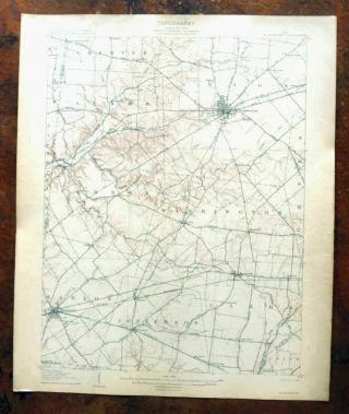
For sale is the 1908 edition of the Sumas 15-minute map. This map would be ideal for framing or display, historical ref...erence or research, genealogy studies, adding to your collection, treasure hunting, a nice conversation piece, a gift for a history or map enthusiast, or for anyone interested in this area. This sheet includes the only survey produced by the United States Geological Survey for the Sumas 15-minute quadrangle. The map is an original 1908 USGS print. This rare 111-year-old-year-old sheet is a first-year printing and is in very good condition. The Sumas 15-minute map shows all roads, paths, towns, railroads, rivers, creeks, elevation contour lines, public land survey lines, county, state, and other administrative boundaries as they existed at the time of the survey in 1906. All known structures (houses, businesses, churches, schools, barns, cabins, etc) are also shown, with exceptions in some urban areas, where only landmark buildings may be shown. The Sumas map was field surveyed before aerial photography methods were widely used in map data gathering. It was drawn by cartographers based on plane table field survey information as well as information gathered from local residents in the area. It displays the remarkable abilities of early government map makers, who placed a strong emphasis on creating complete, accurate, and cartographically appealing maps. Maps from the 15-minute series for the continental United States are no longer produced or printed by the USGS and original prints are becoming increasingly difficult to find. They are a valuable historical record for an area, as they contain many placenames and features that have been dropped from more recent maps. MAP DETAILS Title Sumas State Washington Series 15-minute Surveyed 1906 Field Survey Geographer E.M. Douglas Engraved 1908 Edition 1908 Printed 1908, thick paper stock Woodland Tint No Scale 1:62500 Contour Interval 20 Foot Sheet Dimensions 16 1/2 x 20 inches (approximate) Map Dimensions 11 1/2 x 17 1/2 inches Coverage Area 11 x 17 miles SHEET CONDITION For maps of this vintage, effort is made to note all visible flaws, no matter how minor. Overall Condition VERY GOOD Sheet Notes lightly handled, midsheet horizontal and vertical foldlines, subtle age-toning along fold lines Map Area no markings, no blemishes, pinhole separation at fold line intersection Collar Area no wear, very minor blemishes, small inventory notation in upper right collar corner, inventory stamp on lower collar MAP COVERAGE Quadrangle extent overlaid on current basemap. Browse Nearby
Sheets PLACENAMES Depending on map series and survey date, all of the features listed below may not be shown on this map. This list contains features that currently exist or historically existed within the area covered by this map. The list can be used as a reference to determine if this map covers your area of interest. Placenames are listed alphabetically next to each feature type. Cities and Towns (current) Acme, Bellingham, Deming, Everson, Geneva, Lynden, Nooksack, Strandell, and Sumas Counties Covered Whatcom Rivers and Streams Anderson Creek, Bone Creek, Breckenridge Creek, Carpenter Creek, Dale Creek, Deer Creek, Fishtrap Creek, Fourmile Creek, Johnson Creek, Kinney Creek, Macaulay Creek, Nooksack River, Olsen Creek, Pepin Creek, Silver Creek, Smith Creek, Squalicum Creek, Squaw Creek, Sumas River, Swift Creek, Sygitowicz Creek, Tenmile Creek, and Whatcom Creek Water Bodies Lake Fazon, Fountain Lake, Green Lake, Judson Lake, Lake Whatcom, Squalicum Lake, Toad Lake, and Wiser Lake Populated Places: Agate Bay, Bellingham, Cedarville, Clearbrook, Dewey, Eureka, Everson, Goshen, Greenwood, Hampton, Larson Mill, Laurel, Lawrence, Lynden, Nooksack, Noon, Northwood, Nugents Corner, Roosevelt, Silver Beach, Strandell, Van Wyck, Victor, and Wahl. Locations: Bartlett Beach, Bellingham Country Club, Bellis Fair Mall, Cordata Place, Dutch Village Mall, Haggen Shopping Center, Laurel Gardens, Meridian Village, Northwest Center, Park Manor Shopping Center, Tenmile, and Tenmile Grange. Mountains, Peaks, and Summits: King Mountain, Squalicum Mountain, Stewart Mountain, and Toad Mountain. Parks: Battersby Field, Bloede Donovan Park, Broadway Park, Elizabeth Park, Roosevelt Field, Saint Clair Park, and Whatcom Falls Park. Drainages: Anderson Creek, Breckenridge Creek, Bone Creek, Carpenter Creek, Dale Creek, Fourmile Creek, Kinney Creek, Macaulay Creek, Olsen Creek, Pepin Creek, Smith Creek, Squaw Creek, Swift Creek, Toad Creek, Whatcom Creek, and Wiser Lake Creek. Hospitals: Needham Hospital and Saint Josephs Hospital. Lakes and Ponds: Lake Fazon, Fountain Lake, Green Lake, Squalicum Lake, Toad Lake, Lake Whatcom, and Wiser Lake. Canals: Double Ditch, Kamm Ditch, and Mormon Ditch. Crossings: Iowa Street Interchange, Meridian Street Interchange, and Sunset Street Interchange. Channels: I and J Street Waterway. Dams: Heavens-Lass Lagoon Dam and Whatcom Lake Dam. Reservoirs and Tanks: Heavens-Lass Lagoon and Lake Whatcom. Swamps: Pangborn Lake. Towers: KBFW-AM (Bellingham), KPUG-AM (Bellingham), and KZAZ-FM (Bellingham). Airports: Lynden Airport and Saint Joseph Hospital Campus Heliport. Schools: Assumption School, Bellingham Christian School, Bellingham Senior High School, Christian High School, Columbia Elementary School, Covenant Christian School, Ebenezer Christian School, Everson-Nooksack Elementary School, Fisher Elementary School, Fisher School, Harmony Elementary School, Harmony School, Irene Reither Primary School, Lynden Christian High School, Lynden Christian Schools, Lynden High School, Lynden Middle School, Meridian High School, Meridian Middle School, Nooksack Valley Junior-Senior High School, Nooksack Valley Primary School, Parkview Elementary School, Roeder School, Shuksan Middle School, Silver Beach Elementary School, Sunnyland Elementary School, Washington School, and Whatcom Junior High School. BACKSIDE LEGEND A map summary is printed on the back side of the Sumas sheet similar to the one shown in the picture. It outlines the history, purpose, and status of the USGS mapping program at the time of the printing in 1908. It also provides instructions on how to read contour lines and a description of how they are used to depict the terrain. At the bottom of the page is a legend showing all of the symbols used to represent the cultural, relief, and water features found on the map. SHIPPING AND RETURNS This map sheet will be carefully rolled in a sturdy tube and shipped via the US Postal Service. Shipping and handling costs are included in the purchase price.
If you find that the sheet you receive is not as described in the listing, you may ship it back to us for a refund of the purchase price. 15~114 15~115 15~237 15~238 15~239 15~240 15~241 15~242 15~243 15~365 15~366 15~367 15~368 15~369 30~126 30~127 30~62 30~63 75~17 75~18 75~19 75~20 75~21 75~22 75~23 75~256 75~295 75~296 75~297 75~298 75~299 75~461 75~462 75~523 75~524 75~525 75~526 75~527 75~528 75~58 75~67 75~68 75~69 75~70 75~71 75~718 75~719 75~72 75~73 75~764 75~765 75~766 75~946