HIRAM MAINE 7. 5 Min Quad Topo Map 1964/1966 Saco River Denmark Brownfield ME


Item History & Price
| Reference Number: Avaluer:20439147 | Type: Topographic Map |
| US State: Maine | Format: Sheet Map |
| Date Range: 1960-1969 | Country/Region: United States of America |
| Cartographer/Publisher: USGS | Year: 1966 |
HIRAM QUADRANGLE
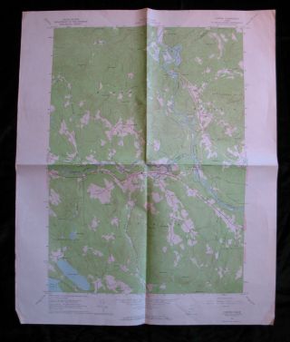
Topographic Map 7.5 Minute Series This 7.5-minute topo map of the Hiram Quadrangle in Maine, is from the United States Department of the Interior Geological Survey. The back is blank.
Title: HIRAM, MAINE
N4352.5 ... - W7045/7.5
Edition: 1964
Reprint Date: 1966 Size: 22 x 27 inches Scale: 1:24, 000 Contour Interval: 20 feet Towns/Cities: Contains all or part of: Denmark, Brownfield, Hiram, Baldwin
Other Features: Saco River, Moose Pond, Beaver Pond, Granger Pond, Walden Pond, Hancock Pond, Barker Pond, Pequawket Pond, Pickett Hill, Fessenden Hill, Allen Mountain, Boston Hills,
Condition: Fair, margins are wrinkled and discolored. Creased where the map was folded in quarters and at the map borders.
Please see my other listings for many more topo maps.
Shipping & Handling is FREE by USPS First Class Mail in the US. Please use the Shipping Calculator to determine the S&H charge to all International addresses. I will gladly discount shipping for multiple auction winners if it is possible to pack the items together. THANK YOU FOR LOOKING!
00077