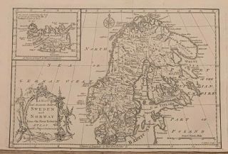
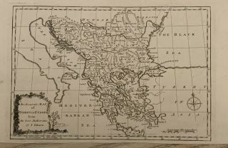
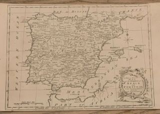
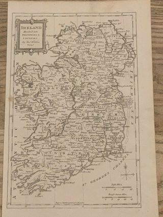
1773 DENMARK ANTIQUE MAP BY JOHN GIBSON 246 YEARS OLD


Item History & Price

Information:
Reference Number: Avaluer:20448960Year: 1773
Original/Reproduction: Antique OriginalFormat: Atlas Map
Date Range: 1700-1799Era: 1700s
Printing Technique: Copper PlateCartographer/Publisher: John Gibson
Country/Region: DenmarkType: Political Map
Original Description:
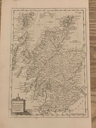
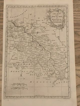
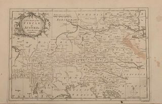
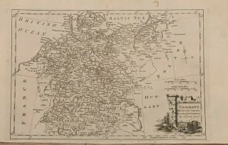
This beautiful map is from A New System of Geography by D. Fenning and J. Collyer, published by J. Payne and J. Johnson, London, 1773.This is an original copper plate engraved map which is printed on one side only and measures 36 cm x 22 cm. This is an original antique which is 246 years old. John Gibson (flourished in London 1750 to his death in 1792) was an English cartographer, geographer, draughtsman and engraver.Recognized as an important late eighteenth-century British carto...grapher, a contemporary of Jacques-Nicolas Bellin and skilled engraver, spent most of his life in prison because of several debts, however, produced thousands of maps and its best-known work in 1758 was called the pocket atlas Atlas Minimus. He worked also for the Gentleman's Magazine for which engraved different decorative maps. He also published his own work in The Universal Magazine of Knowledge and Pleasure, The Universal Museum and The Universal Traveller.Please check my other listings for more antique maps, antique prints and antiquarian books and atlases.


    Similar items


  • 1773 Sweden Norway Iceland Antique Map By John Gibson 246 Years Old

    1773 Sweden Norway Iceland Antique Map By John Gibson 246 Years Old

  • 1773 Turkey In Europe Balkans Antique Map By John Gibson 246 Years Old

    1773 Turkey In Europe Balkans Antique Map By John Gibson 246 Years Old

  • 1773 Spain & Portugal Antique Map By John Gibson 246 Years Old

    1773 Spain & Portugal Antique Map By John Gibson 246 Years Old

  • 1773 Ireland Antique Map By Thomas Kitchin 246 Years Old

    1773 Ireland Antique Map By Thomas Kitchin 246 Years Old

  • 1773 Scotland Antique Map By Thomas Kitchin 246 Years Old

    1773 Scotland Antique Map By Thomas Kitchin 246 Years Old

  • 1773 Silesia Antique Map By George Rollos 246 Years Old

    1773 Silesia Antique Map By George Rollos 246 Years Old

  • 1773 Austria Antique Map By George Rollos 246 Years Old

    1773 Austria Antique Map By George Rollos 246 Years Old

  • 1773 Germany Antique Map By Thomas Kitchin 246 Years Old

    1773 Germany Antique Map By Thomas Kitchin 246 Years Old


    • You might also like


    • Hungary & Romania 1579 (1584) Ortelius Unusual Antique Copper Engraved Map

      Hungary & Romania 1579 (1584) Ortelius Unusual Antique Copper Engraved Map

    • Brussels Bruxelles Belfium 1777 De Ferraris & Dupuis Large Antique Map Sheet Xxi

      Brussels Bruxelles Belfium 1777 De Ferraris & Dupuis Large Antique Map Sheet Xxi

    • 1616 Atlas Map Of Iceland.

      1616 Atlas Map Of Iceland.

    • Kazan Russia 1767 Le Clerc/lespinasse Antique Copper Engraved City View

      Kazan Russia 1767 Le Clerc/lespinasse Antique Copper Engraved City View

    • 1899 Stanford,  Folding Map Of Norwich,  Norfolk,  Arthur Collins,  Jarrold & Sons,

      1899 Stanford, Folding Map Of Norwich, Norfolk, Arthur Collins, Jarrold & Sons,

    • 1948 Vintage Linen Colour Map Geological Survey Ten Mile Of Great Britain

      1948 Vintage Linen Colour Map Geological Survey Ten Mile Of Great Britain

    • 1944 Map Flying Bombs Sussex Ww2 Newspaper Military Kent Courier German V1 V2

      1944 Map Flying Bombs Sussex Ww2 Newspaper Military Kent Courier German V1 V2

    • Dated 1638 Vellum Map Of Icklesham Sussex Showing Land Uses Owners Etc

      Dated 1638 Vellum Map Of Icklesham Sussex Showing Land Uses Owners Etc

Avaluer          About Us          Privacy Policy          Contact Us          UP
© 2022, avaluer.net, Inc. or its affiliates