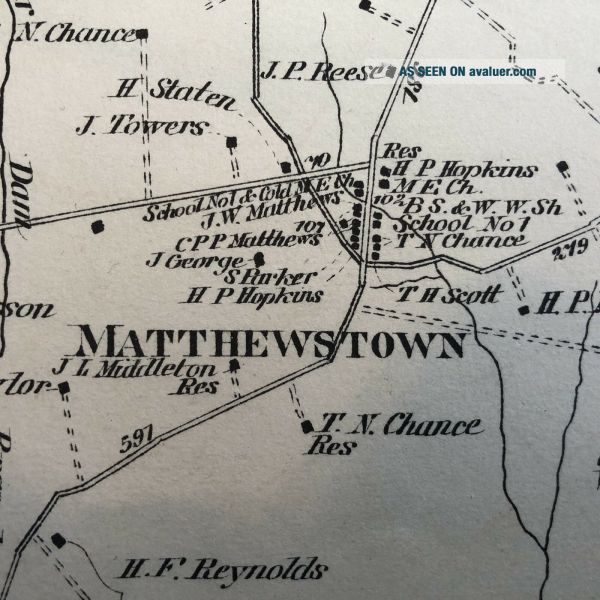
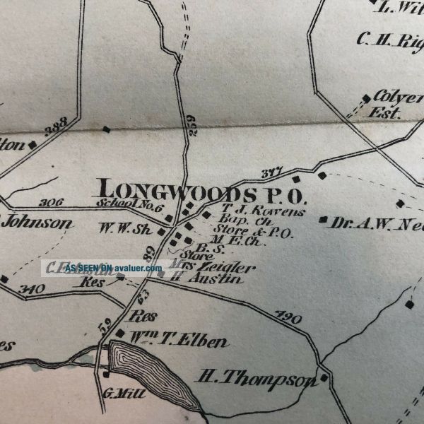
Rare 1877 TALBOT COUNTY Maryland Hand Color STREET MAP Matthewstown WYE MILLS
Item History & Price
| Reference Number: Avaluer:23755468 |
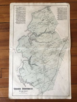
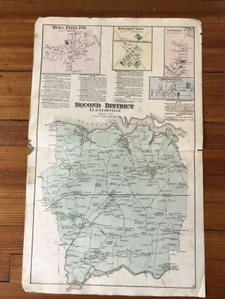
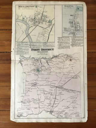
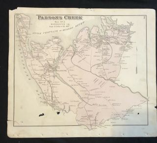
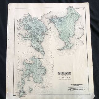
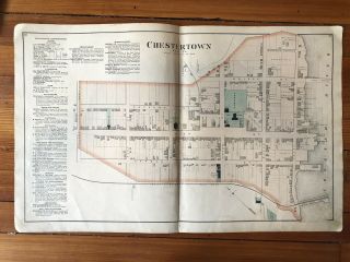
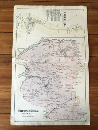
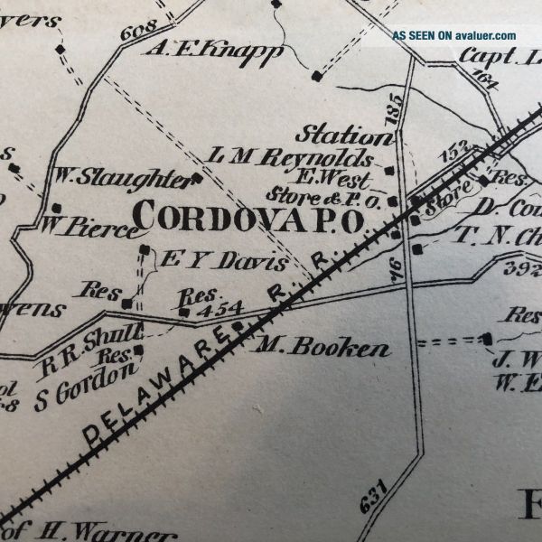
Rare 1877 TALBOT COUNTY, Maryland Hand-Colored double-page, poster-like STREET MAP of of the Chapel District, including Matthewstown, Wye Mills, Cordova, Longwoods and more, depicting property footprints in Oakland Mills and PROPERTY OWNER NAMES - #mb049Please visit our ebay store for printed on the front page other FANTASTIC Americana, Antiquarian Books and Ephemera.SEE PHOTO-----COMPLETE, ORIGINAL RARE 1877 EASTERN SHORE of MARYLAND street map of the Chapel District in Talbo...t County, from the scarce Lake, Griffing & Stevenson Atlas of The Eastern Shore of Maryland.Perfect for framing and display, this beautiful piece measures 16" X 26" and would look GREAT hanging in any modern-day water front TALBOT COUNTY home!The founding date of Talbot County is not known. It existed by February 12, 1661, when a writ was issued to its sheriff. It was initially divided into nine Hundreds and three parishes: St. Paul's, St. Peter's and St. Michael's.In 1667, the first meeting of Commissions was held in the home known as Widow Winkles on the Skipton Creek near the town of York. The town of York was vacated once the courthouse was to be built on Armstrongs Old Field in 1709 near Pitts' Bridge. The new courthouse designated because York was too far north in the county once Queen Anne's County received their charter and was lopped off of Talbot County.[5] Pitts' Bridge was just north of the Quaker Meeting House, but most importantly, it faced the Indian trail (Washington Street - Easton).After the American Revolutionary War in 1786, Act to Assemble in Annapolis appointed John Needles to survey and "to erect a town in Talbot County to be called Talbottown"—laying out a town around then existing court house with 118 number parcels of land and designated streets, alleys and lanes. Talbottown was to be known as the county seat of Easton. Another act was passed in 1789 to build a larger courthouse on the site of the old one. This court house was completed in 1794 and today parts of it still stand today inside of the present court house.Lt. Col. Tench Tilghman, Gen. George Washington's Aide-De-Camp, was born on Fausley in Talbot County on December 25, 1744. He died on April 18, 1786, and is buried in Oxford, Maryland.On the monument at the grave site, an inscription reads: Tench Tilghman Lt. Col. in the Continental Army And Aid de-camp of Washington Who spoke Him thus: He was in Every Action in which the Main Army was concerned a great part of the Time. He refused to receive Pay. While living no man could be more Esteemed and since dead none more Lamented than Col. Tilghman. No one had imbibed Sentiments of greater Friendship for Him than I had done. He left as Fair a Reputation as Ever belonged to a Human Character. Died April 18, 1786 Aged 42On his actual grave an inscription reads "In memory of Col. Tench Tilghman who died April 18, 1786 in the 42nd year of his age. Very much lamented. He took an early and active part in the great contest that secured the Independence of the United States of America. He was an Aide-de-Camp to His Excellency General George Washington Commander in Chief of the American Armies and was Honoured with his Friendship, Confidence and he was one of those whose merit were Disinguished and Honourable Reward By the Congress But Still more to his Praise He was a Good Man".Founding Father John Dickinson was born in Trappe; the abolitionist Frederick Douglass was born into slavery near Tuckahoe Creek. A statue of Douglass stand in front of the Talbot County Courthouse.The first established hospital on the Eastern Shore was near McDaniel at Dr. Absolom Thompson farm, the old Mary's Delight Farm.The county has a number of properties on the National Register of Historic Places.The river was named for the powerful Nanticoke Indian Confederacy that dwelled along its shores, and navigated its waters from the Chesapeake Bay to the inland reaches of Delaware. The first recorded European contact came when Captain John Smith encountered the Nanticokes near present day Vienna on his historic voyage of exploration around the bay and up the Nanticoke in 1608.Vienna is currently embarked on a long range waterfront development plan called Emperor's Landing, which when completed will showcase the town's rich Nanticoke River and Chesapeake Bay legacy. We invite you to visit and join our journey of discovery.Very Good condition, with mild edge wear along the edges. This listing includes the complete entire original map. VINTAGE BOOKS AND FINE ART stands behind all of the items that we sell with a no questions asked, money back guarantee. Every item we sell is original printed on the date indicated at the beginning of its description, unless clearly stated as a reproduction in the header AND text body. U.S. buyers pay calculated priority postage which includes waterproof plastic and a heavy cardboard flat to protect your purchase from damage in the mail. International postage is quoted when we are informed as to where the package is to be sent. We do combine postage (to reduce postage costs) for multiple purchases sent in the same package. We accept payment by PAYPAL. We ship packages daily. This is truly a piece OF HISTORY that YOU CAN OWN!