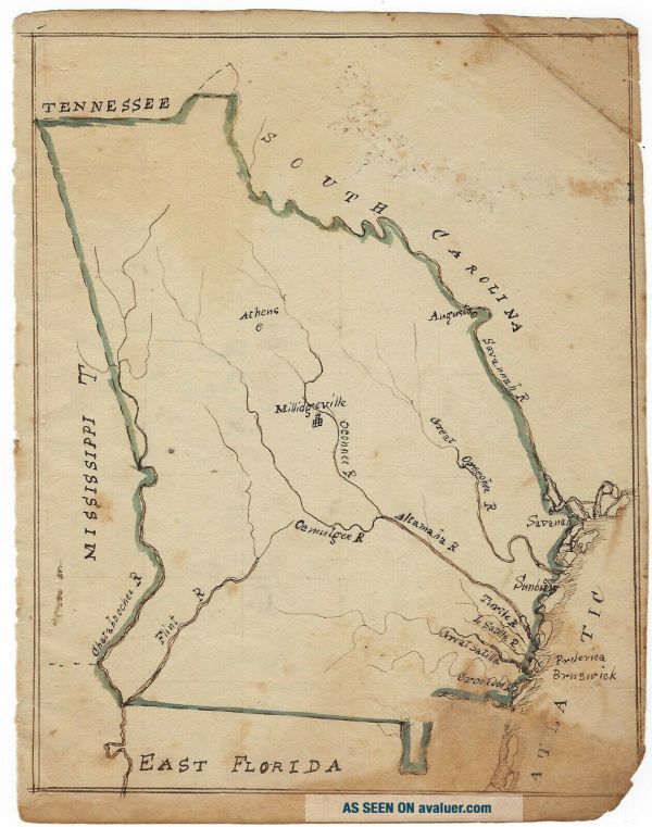
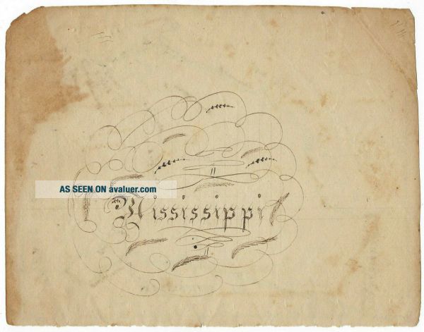
Georgia - Early 19th - Century Hand - Drawn Map
Item History & Price
| Reference Number: Avaluer:23756098 | Printing Technique: Manuscript/Hand drawn |
| Date Range: 1800-1899 | Original/Reproduction: Antique Original |
| Country/Region: United States of America | US State: Georgia |
A hand-drawn map of the state of Georgia, approximately 8" x 6". It was most likely created by a schoolchild in the early-19th century. There is toning along the bottom edge, chipping on the edges, and wear to the top right corner. #7-20 #1
TERMS AND CONDITIONS My name is Stuart Lutz and I am a full time dealer of autographs, letters, documents and historic manuscripts. I am a member of the Manuscript Society, theProfessional Autograph Dealers Association, the Antiq...uarian Booksellers Associationof America, the Appraisers Association of America (Certified in the field of Historic Documents), the Universal AutographCollectors Club (Registered Dealer #166) and the Ephemera Society. I am the historical document appraiser andauthenticator for the History Channel program Pawn Stars. I guarantee the authenticity of this piece forever, and will gladlyrefund your money if it is ever proven not to be authentic (not many Ebayautograph dealers boast of that!). All itemsare issued with an invoice that states in writing at the bottom "All autographsand historical papers are guaranteed authentic for life by me. If any piece is ever proven not to begenuine, I will gladly refund the full purchase price to the original buyer." Your piece will be professionally packed and shipped, will befully insured, and will be sent by trackable USPS mail. I offer interest-free layaway plans, but please contact me beforebidding to notify me that you would like a payment plan. These plans spread out three equal paymentsover three consecutive months; the first payment is due within seven days ofthe purchase agreement and is NON-REFUNDABLE for any reason. Full payment is expected within five days, unless other previousarrangements have been made. New Jersey residents, please add 7% for the Governor's salary ;-). Buyers who do not live in the United States must pay using PayPal Best of luck bidding and thanks for your business!
TERMS AND CONDITIONS My name is Stuart Lutz and I am a full time dealer of autographs, letters, documents and historic manuscripts. I am a member of the Manuscript Society, theProfessional Autograph Dealers Association, the Antiq...uarian Booksellers Associationof America, the Appraisers Association of America (Certified in the field of Historic Documents), the Universal AutographCollectors Club (Registered Dealer #166) and the Ephemera Society. I am the historical document appraiser andauthenticator for the History Channel program Pawn Stars. I guarantee the authenticity of this piece forever, and will gladlyrefund your money if it is ever proven not to be authentic (not many Ebayautograph dealers boast of that!). All itemsare issued with an invoice that states in writing at the bottom "All autographsand historical papers are guaranteed authentic for life by me. If any piece is ever proven not to begenuine, I will gladly refund the full purchase price to the original buyer." Your piece will be professionally packed and shipped, will befully insured, and will be sent by trackable USPS mail. I offer interest-free layaway plans, but please contact me beforebidding to notify me that you would like a payment plan. These plans spread out three equal paymentsover three consecutive months; the first payment is due within seven days ofthe purchase agreement and is NON-REFUNDABLE for any reason. Full payment is expected within five days, unless other previousarrangements have been made. New Jersey residents, please add 7% for the Governor's salary ;-). Buyers who do not live in the United States must pay using PayPal Best of luck bidding and thanks for your business!