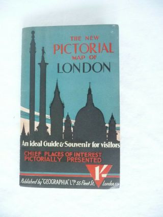
Old Map Of England The Pictorial Map Of London Cloth Map


Item History & Price

Information:
Reference Number: Avaluer:23756566Cartographer/Publisher: Geographia
City: LondonOriginal/Reproduction: Vintage Original
Date Range: 1930-1939Format: Folding Map
Country/Region: EnglandType: City Map
Original Description:
this is an old map in an old booklet cover. It is titled The New Pictorial Map of London "an ideal guide & souvenir for visitors. Chief Places of interest pictorially presented on cloth 2' published by Geographia Ltd. made in Londona. It does not have a date printed on it but looks like it might be from the 1930's. the map is 29.75 x 19 3/8 inches.  the cover has a little wear. and inside the map unfolds but is still attached to the map in one small  spot at the top. the ...map itself is in very good condition aside from The National  Gallery area being circled in felt pen. Paypal accepted. Buyer pays shipping and handling of $4.00 in the US more for international shipping. 


    Similar items


  • Old Art Map Of England The Pictorial Map Of London

    Old Art Map Of England The Pictorial Map Of London

  • Vtg Old English Staffordshire England The Little White House Plate Blue White

    Vtg Old English Staffordshire England The Little White House Plate Blue White

  • Old Royal Doulton England - The Gardener - Toby Water Pitcher - Perfect

    Old Royal Doulton England - The Gardener - Toby Water Pitcher - Perfect

  • Old Royal Doulton England The Vernon Pat Blue D5124 Lrg 17 X 14 Serving Platter

    Old Royal Doulton England The Vernon Pat Blue D5124 Lrg 17 X 14 Serving Platter

  • Postcard Old Vintage Card England The Royal Family Rare 1940

    Postcard Old Vintage Card England The Royal Family Rare 1940 ' S

  • Carte Postale Old Postcard Kingdom England The Lion In His Mane Written 1919

    Carte Postale Old Postcard Kingdom England The Lion In His Mane Written 1919

  • The Kingdom Of England Old Map Framed

    The Kingdom Of England Old Map Framed

  • 1930

    1930 ' S Pictoral /pictorial Map Of White Mountains Nh. W/ Old Man Of The Mountain


    • You might also like


    • Hungary & Romania 1579 (1584) Ortelius Unusual Antique Copper Engraved Map

      Hungary & Romania 1579 (1584) Ortelius Unusual Antique Copper Engraved Map

    • Brussels Bruxelles Belfium 1777 De Ferraris & Dupuis Large Antique Map Sheet Xxi

      Brussels Bruxelles Belfium 1777 De Ferraris & Dupuis Large Antique Map Sheet Xxi

    • 1616 Atlas Map Of Iceland.

      1616 Atlas Map Of Iceland.

    • Kazan Russia 1767 Le Clerc/lespinasse Antique Copper Engraved City View

      Kazan Russia 1767 Le Clerc/lespinasse Antique Copper Engraved City View

    • 1899 Stanford,  Folding Map Of Norwich,  Norfolk,  Arthur Collins,  Jarrold & Sons,

      1899 Stanford, Folding Map Of Norwich, Norfolk, Arthur Collins, Jarrold & Sons,

    • 1948 Vintage Linen Colour Map Geological Survey Ten Mile Of Great Britain

      1948 Vintage Linen Colour Map Geological Survey Ten Mile Of Great Britain

    • 1944 Map Flying Bombs Sussex Ww2 Newspaper Military Kent Courier German V1 V2

      1944 Map Flying Bombs Sussex Ww2 Newspaper Military Kent Courier German V1 V2

    • Dated 1638 Vellum Map Of Icklesham Sussex Showing Land Uses Owners Etc

      Dated 1638 Vellum Map Of Icklesham Sussex Showing Land Uses Owners Etc

Avaluer          About Us          Privacy Policy          Contact Us          UP
© 2022, avaluer.net, Inc. or its affiliates