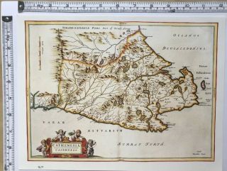
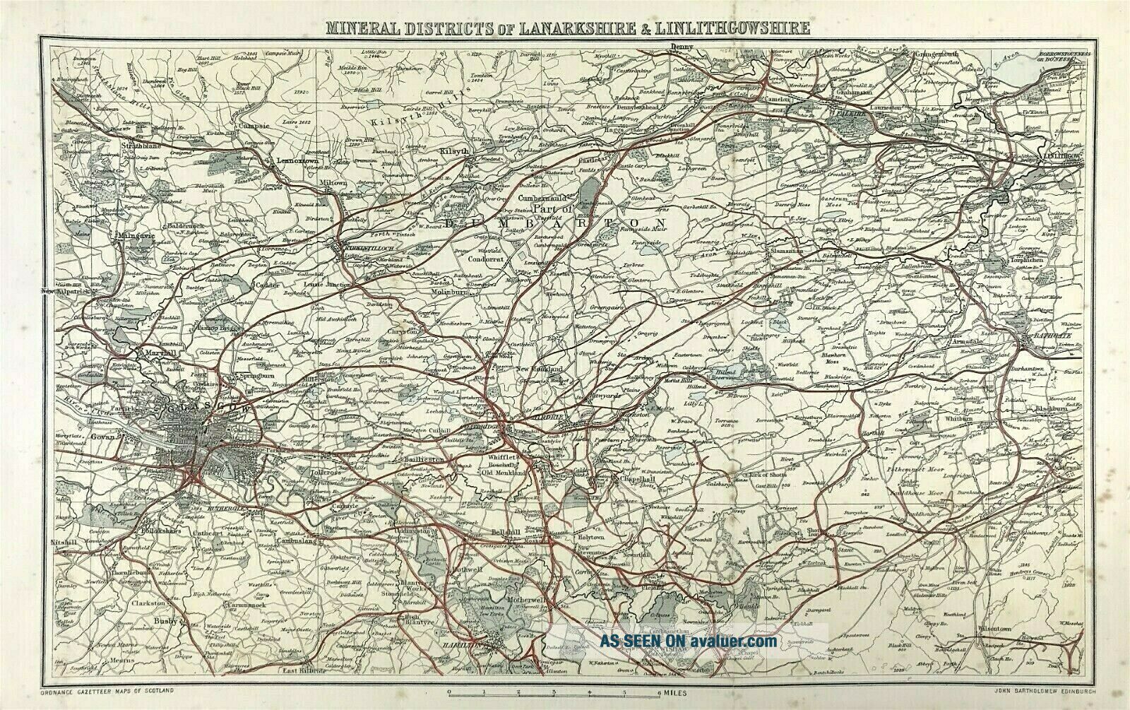
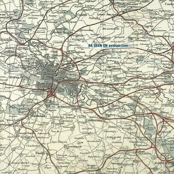
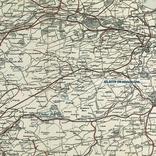
Old Map Lanarkshire Linlithgowshire Mineral Districts Gazetteer Scotland 1882


Item History & Price

Information:
Reference Number: Avaluer:25486714County: Lanarkshire, Linlithgowshire
Type: County MapCartographer/Publisher: John Bartholomew
Year: 1882Original/Reproduction: Antique Original
Country/Region: ScotlandFormat: Atlas
Era: 1800s
Original Description:

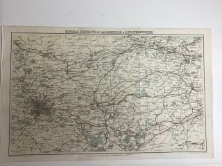
Antique Map Lanarkshire Linlithgowshire Mineral Districts c1882
Original plate from the Ordnance Gazetteer of Scotland
Compiled from the most recent authorities. Published by John Bartholomew, Edinburgh c1882.
Good condition, fine detail, some age tone, creasing to boarders, colour,
Approx engraved area: 230mm x 375mm (9" x 14.75")
Blank to verso and folds as published

ANOTHER GENUINE ANTIQUE PRINT
FROM RARE MAPS AND PRINTS


    Similar items


  • Antique Map Tweed Manufacturing Districts Gazetteer Scotland 1882 Bartholomew

    Antique Map Tweed Manufacturing Districts Gazetteer Scotland 1882 Bartholomew

  • 1884 Old Antique Colour Map,  Scotland,  Lanarkshire & Linlithgowshire,  Glasgow

    1884 Old Antique Colour Map, Scotland, Lanarkshire & Linlithgowshire, Glasgow

  • Old Ordnance Survey Maps Bathgate Linlithgowshire Scotland 1896 Special Offer

    Old Ordnance Survey Maps Bathgate Linlithgowshire Scotland 1896 Special Offer

  • Historic Antique Vintage Old Map: Orkney & Shetland,  Scotland 1600s Reprint

    Historic Antique Vintage Old Map: Orkney & Shetland, Scotland 1600s Reprint

  • Historic Antique Vintage Old Map Of Caithness,  Scotland 1600

    Historic Antique Vintage Old Map Of Caithness, Scotland 1600 ' S: Reprint

  • Historic Antique Vintage Old Map: Lewis,  Harris,  Flannan Scotland 1600s Reprint

    Historic Antique Vintage Old Map: Lewis, Harris, Flannan Scotland 1600s Reprint

  • Northern Lake District,  Old Map,  1880s,  Wh Smith,  Cumbria

    Northern Lake District, Old Map, 1880s, Wh Smith, Cumbria

  • Old Ordnance Survey Map Hampshire Alresford Alton District & Plan Selborne 1893

    Old Ordnance Survey Map Hampshire Alresford Alton District & Plan Selborne 1893


    • You might also like


    • Hungary & Romania 1579 (1584) Ortelius Unusual Antique Copper Engraved Map

      Hungary & Romania 1579 (1584) Ortelius Unusual Antique Copper Engraved Map

    • Brussels Bruxelles Belfium 1777 De Ferraris & Dupuis Large Antique Map Sheet Xxi

      Brussels Bruxelles Belfium 1777 De Ferraris & Dupuis Large Antique Map Sheet Xxi

    • 1616 Atlas Map Of Iceland.

      1616 Atlas Map Of Iceland.

    • Kazan Russia 1767 Le Clerc/lespinasse Antique Copper Engraved City View

      Kazan Russia 1767 Le Clerc/lespinasse Antique Copper Engraved City View

    • 1899 Stanford,  Folding Map Of Norwich,  Norfolk,  Arthur Collins,  Jarrold & Sons,

      1899 Stanford, Folding Map Of Norwich, Norfolk, Arthur Collins, Jarrold & Sons,

    • 1948 Vintage Linen Colour Map Geological Survey Ten Mile Of Great Britain

      1948 Vintage Linen Colour Map Geological Survey Ten Mile Of Great Britain

    • 1944 Map Flying Bombs Sussex Ww2 Newspaper Military Kent Courier German V1 V2

      1944 Map Flying Bombs Sussex Ww2 Newspaper Military Kent Courier German V1 V2

    • Dated 1638 Vellum Map Of Icklesham Sussex Showing Land Uses Owners Etc

      Dated 1638 Vellum Map Of Icklesham Sussex Showing Land Uses Owners Etc

Avaluer          About Us          Privacy Policy          Contact Us          UP
© 2022, avaluer.net, Inc. or its affiliates