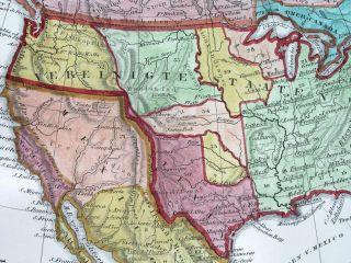
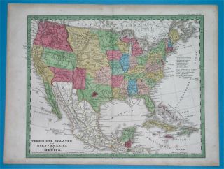
1874 USA ATLANTIC OCEAN STATES FLORIDA YORK VIRGINIA CAROLINA AMERICA Map

Item History & Price
| Reference Number: Avaluer:25570585 | Date Range: 1800-1899 |
| Printing Technique: Lithography | Original/Reproduction: Vintage Original |
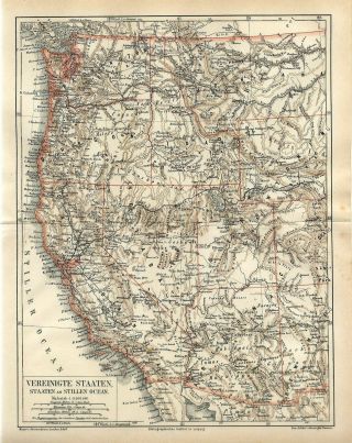
1874 USA ATLANTIC OCEAN STATES FLORIDA NEW YORK VIRGINIA CAROLINA AMERICA Map
...
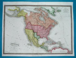
!!!!!!!! Bright stripes on the print does only the scanner it is not on the original picture !!!!!!!! Original old German map/double page OLD BOOK PLATE. This is authentic antique(not a modern reproduction)beautiful map comes from a German lexicon. Very decorative.Looks great when framed. Printed by Bibliographisches Institut Leipzig, 1874. The overall size of this print with margins approx 11 3/4" x 9 3/4" or 30cm x 24, 5cm and suitable for framing. The print was folded inside the book and has original centrefold. Condition can be see from the scan. PLEASE NOTE !!!!!!!!! FOR MULTIPLE BUYERS. All combined items must be paid once a week.After reading all of auction, Please ask any and all questions BEFORE bidding! Thank YouIf you have questions or problems before OR after you receive an item, PLEASE contact me ASAP. I leave feedback for everyone, once transaction is complete and feedback has been left for us. I believe in and encourage good communication! Selling from a private collection. We accept returns ONLY if there is a problem(or damage) on the item.
Shipping $8.00 for 1-3 prints via registered airmail or up to 20 regular size prints for $14.00 via registered airmail. Shipping will be in a strong tube!!!FOR MULTIPLE BUYERS Please contact us about multiple purchases.All combined items must be paid once a week.PLEASE NOTE !!!! 24 days after auction ends, eBay will automatically open a case for unpaid items. Shipping from Europe, Slovakia. Please allow approximately two-three weeks for delivery from Europe after payment received. Payment by PayPal. DO NOT DUPLICATE OR COPY! Template Made By: © Inkfrog Template Center
Auction Templates, Logos, Store fronts and more!
inkfrog terapeak
...
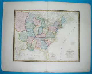
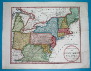
!!!!!!!! Bright stripes on the print does only the scanner it is not on the original picture !!!!!!!! Original old German map/double page OLD BOOK PLATE. This is authentic antique(not a modern reproduction)beautiful map comes from a German lexicon. Very decorative.Looks great when framed. Printed by Bibliographisches Institut Leipzig, 1874. The overall size of this print with margins approx 11 3/4" x 9 3/4" or 30cm x 24, 5cm and suitable for framing. The print was folded inside the book and has original centrefold. Condition can be see from the scan. PLEASE NOTE !!!!!!!!! FOR MULTIPLE BUYERS. All combined items must be paid once a week.After reading all of auction, Please ask any and all questions BEFORE bidding! Thank YouIf you have questions or problems before OR after you receive an item, PLEASE contact me ASAP. I leave feedback for everyone, once transaction is complete and feedback has been left for us. I believe in and encourage good communication! Selling from a private collection. We accept returns ONLY if there is a problem(or damage) on the item.
Shipping $8.00 for 1-3 prints via registered airmail or up to 20 regular size prints for $14.00 via registered airmail. Shipping will be in a strong tube!!!FOR MULTIPLE BUYERS Please contact us about multiple purchases.All combined items must be paid once a week.PLEASE NOTE !!!! 24 days after auction ends, eBay will automatically open a case for unpaid items. Shipping from Europe, Slovakia. Please allow approximately two-three weeks for delivery from Europe after payment received. Payment by PayPal. DO NOT DUPLICATE OR COPY! Template Made By: © Inkfrog Template Center
Auction Templates, Logos, Store fronts and more!
inkfrog terapeak