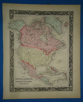
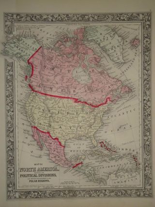
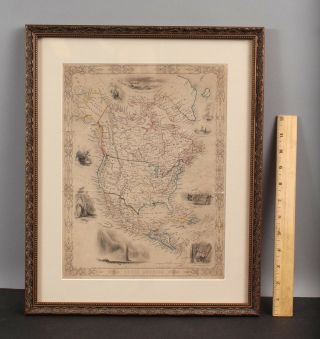
Antique Framed 1860 NORTH AMERICA MAP Vibrant Hand Colored


Item History & Price

Information:
Reference Number: Avaluer:28461198Cartographer/Publisher: Mitchell's General Atlas
Type: 1860 Mitchell Atlas MapPrinting Technique: Authentic 1860 Map
Genuine: Authentic Early Map not a ReproductionOriginal/Reproduction: Antique Original
COLOR: Vibrant Crisp Original Hand ColoringFormat: Atlas Map
Year: 1860Publication Year: 1860
US State: REF#MITCHELL1860/081719Features: Vintage Hand Colored
Date Range: 1800-1899Map: Early American Map
Country/Region: American States & Territories
Original Description:
Original hand colored map of North America from Mitchell's atlas in pristine condition, professionally matted and framed, image size, including the floral border is 10 1/2" x 13 1/2"


    Similar items


  • Vintage Circa 1860 North America Map Old Antique Vibrant Hand Colored

    Vintage Circa 1860 North America Map Old Antique Vibrant Hand Colored

  • Vintage 1860 North America Map Old Antique Atlas Map 082417

    Vintage 1860 North America Map Old Antique Atlas Map 082417

  • 19thc Antique George Virtue North America Map Engraving W/ Western Vignettes

    19thc Antique George Virtue North America Map Engraving W/ Western Vignettes

  • Vintage Circa 1860 Maine Map Old Antique Vibrant Hand Colored

    Vintage Circa 1860 Maine Map Old Antique Vibrant Hand Colored

  • Vintage Circa 1860 Pacific Ocean Map Old Antique Vibrant Hand Colored

    Vintage Circa 1860 Pacific Ocean Map Old Antique Vibrant Hand Colored

  • Vintage Circa 1860 Ireland Scotland Map Old Antique Vibrant Hand Color

    Vintage Circa 1860 Ireland Scotland Map Old Antique Vibrant Hand Color

  • Vintage Circa 1860 Texas Map Old Antique Vibrant Hand Colored Atlas Map

    Vintage Circa 1860 Texas Map Old Antique Vibrant Hand Colored Atlas Map

  • Vintage Circa 1860 California Map Old Antique Vibrant Hand Colored

    Vintage Circa 1860 California Map Old Antique Vibrant Hand Colored


    • You might also like


    • 1860 Mitchell Hand Colored Map Colorado,  Nebraska & Kansas - Civil War Era

      1860 Mitchell Hand Colored Map Colorado, Nebraska & Kansas - Civil War Era

    • 18th Century French Map Of North America

      18th Century French Map Of North America

    • Las Vegas Nevada Vintage 1967 Us Geological Survey Quadrangle Map 4 Panels

      Las Vegas Nevada Vintage 1967 Us Geological Survey Quadrangle Map 4 Panels

    • Rare Antique 1845 Maps United States Exploring Expedition Book Antartica Hawaii

      Rare Antique 1845 Maps United States Exploring Expedition Book Antartica Hawaii

    • Vintage 1926 Map Hollywood From The Best Surveys Of The Time

      Vintage 1926 Map Hollywood From The Best Surveys Of The Time

    • American Continent (western Hemisphere) 1747 Bowen Antique Copper Engraved Map

      American Continent (western Hemisphere) 1747 Bowen Antique Copper Engraved Map

    • Gulf Coast Florida Texas United States 1705 De Fer Unusual Antique Engraved Map

      Gulf Coast Florida Texas United States 1705 De Fer Unusual Antique Engraved Map

    • California As Island United States 1700 De Fer Unusual First Edition Antique Map

      California As Island United States 1700 De Fer Unusual First Edition Antique Map

Avaluer          About Us          Privacy Policy          Contact Us          UP
© 2022, avaluer.net, Inc. or its affiliates