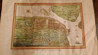
Antique Map, Nouveau Plan De Ville De Rome


Item History & Price

Information:
Reference Number: Avaluer:29296
Original Description:
Title: Nouveau plan de ville de Rome tire par ordre du Pape par Matteo Gregoria de Romans tres utille pour les voiageurs Description:A fine bird's-eye view of Rome with inset views of churches and papal palaces. An index identifies over 300 places of note. As the title implies, this map was intended as a tourist guide.Publication: Atlas Historique, ou nouvelle introduction a l'histoire, a la chronologie & a la geographie ancienne & moderne. A Amersterdam, chez L'Hoinore & C...hatelain Libraires. Author: Chatelain. H, . Vol. 1, publ. 1721Cartographer: Henri Abraham Chatelain (1684 - 1743) was a Huguenot pastor of Parisian origins. He lived consecutively in Paris, St. Martins, London (c. 1710), The Hague (c. 1721) and Amsterdam (c. 1728). He is best known as a Dutch cartographer and more specifically for his cartographic contribution in the seminal seven volume Atlas Historique, published in Amsterdam between 1705 and 1720. Innovative for its time, the Atlas Historique combined fine engraving and artwork with scholarly studies of geography, history, ethnology, heraldry, and cosmography. Some scholarship suggests that the Atlas Historique was not exclusively compiled by Henri Chatelain, as is commonly believed, but rather was a family enterprise involving Henri, his father Zacharie (d.1723) and his brother, also Zacharie (1690 – 1754). They worked as a partnership publishing the Atlas under several different Chatelain imprints, depending on the Chatelain family partnerships at the time of publication. The atlas was published in seven volumes between 1705 and 1720, with a second edition appearing in 1732. The maps were accompanied by information pertaining to cosmography, geography, history, chronology, genealogy, topography, heraldry, and costume of the world. The images incorporated into the plates and tables were drawn from the best available contemporary sources, including the works of Dapper, Chardin, de Bruyn and Le Hay. Many of the maps are based on the work of Guillaume de l'Lisle. Condition: Very good. The sheet is evenly aged toned, commensurate with its age. Folds as issued. Blank verso. If there are minor tears they have been mended with archival tissue. The attached photo is part of the item description, please examine carefully. Color: UncolouredSize (h x w): 44.0 x 52.5 cm. (Sheet)Technique: copper-plate engraving.Ref: JJB2357
Powered by eBay Turbo Lister


    Similar items


  • 1761 Antique Map Bellin - Plan De La Ville De Cochin India Kochi Kerala

    1761 Antique Map Bellin - Plan De La Ville De Cochin India Kochi Kerala

  • Nouveau Plan De Paris En 20 Arrondissements By J.  Migeon C1869

    Nouveau Plan De Paris En 20 Arrondissements By J. Migeon C1869

  • Beauvais Antique Town City Plan De La Ville.  Oise Carte.  Baedeker 1909 Old Map

    Beauvais Antique Town City Plan De La Ville. Oise Carte. Baedeker 1909 Old Map

  • Epinal Antique Town City Plan De La Ville.  Vosges.  Épinal Carte 1899 Old Map

    Epinal Antique Town City Plan De La Ville. Vosges. Épinal Carte 1899 Old Map

  • Troyes Antique Town City Plan De La Ville.  Aube Carte.  Baedeker 1909 Old Map

    Troyes Antique Town City Plan De La Ville. Aube Carte. Baedeker 1909 Old Map

  • Amiens Antique Town City Plan De La Ville.  Somme Carte.  Baedeker 1900 Old Map

    Amiens Antique Town City Plan De La Ville. Somme Carte. Baedeker 1900 Old Map

  • Le Mans Antique Town City Plan De La Ville.  Sarthe Carte.  Baedeker 1905 Map

    Le Mans Antique Town City Plan De La Ville. Sarthe Carte. Baedeker 1905 Map

  • Lille Antique Town City Plan De La Ville.  Nord.  France Carte.  Baedeker 1905 Map

    Lille Antique Town City Plan De La Ville. Nord. France Carte. Baedeker 1905 Map


    • You might also like


    • Hungary & Romania 1579 (1584) Ortelius Unusual Antique Copper Engraved Map

      Hungary & Romania 1579 (1584) Ortelius Unusual Antique Copper Engraved Map

    • Brussels Bruxelles Belfium 1777 De Ferraris & Dupuis Large Antique Map Sheet Xxi

      Brussels Bruxelles Belfium 1777 De Ferraris & Dupuis Large Antique Map Sheet Xxi

    • 1616 Atlas Map Of Iceland.

      1616 Atlas Map Of Iceland.

    • Kazan Russia 1767 Le Clerc/lespinasse Antique Copper Engraved City View

      Kazan Russia 1767 Le Clerc/lespinasse Antique Copper Engraved City View

    • 1899 Stanford,  Folding Map Of Norwich,  Norfolk,  Arthur Collins,  Jarrold & Sons,

      1899 Stanford, Folding Map Of Norwich, Norfolk, Arthur Collins, Jarrold & Sons,

    • 1948 Vintage Linen Colour Map Geological Survey Ten Mile Of Great Britain

      1948 Vintage Linen Colour Map Geological Survey Ten Mile Of Great Britain

    • 1944 Map Flying Bombs Sussex Ww2 Newspaper Military Kent Courier German V1 V2

      1944 Map Flying Bombs Sussex Ww2 Newspaper Military Kent Courier German V1 V2

    • Dated 1638 Vellum Map Of Icklesham Sussex Showing Land Uses Owners Etc

      Dated 1638 Vellum Map Of Icklesham Sussex Showing Land Uses Owners Etc

Avaluer          About Us          Privacy Policy          Contact Us          UP
© 2022, avaluer.net, Inc. or its affiliates