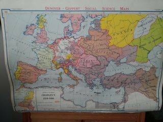
Vintage Denoyer - Geppert Large Pull Down 1965 Map Of Europe


Item History & Price

Information:
Reference Number: Avaluer:30339765Cartographer/Publisher: Denoyer-Geppert
Type: Political MapOriginal/Reproduction: Vintage Original
Year: 1965Format: Pull Down Map
Country/Region: Europe
Original Description:
1965 classroom pull down map of Europe on cloth with brackets 


    Similar items


  • Vintage Denoyer - Geppert Large Pull Down 1960 Map Of Africa

    Vintage Denoyer - Geppert Large Pull Down 1960 Map Of Africa

  • Vintage Denoyer - Geppert Large Pull Down Us Map 12 Layers Canvas Us History

    Vintage Denoyer - Geppert Large Pull Down Us Map 12 Layers Canvas Us History

  • Vintage Denoyer - Geppert Large Pull Down Roll Up 7 Layer Canvas Map Set

    Vintage Denoyer - Geppert Large Pull Down Roll Up 7 Layer Canvas Map Set

  • Vintage 1960

    Vintage 1960 ' S Denoyer - Geppert Large Pull Down Roll Up 7 Layer Canvas Map

  • Vintage Europe Roll Up Map Denoyer - Geppert School Pull Down

    Vintage Europe Roll Up Map Denoyer - Geppert School Pull Down

  • Antique Denoyer - Geppert Co.  Pull Down U.  S.  Chalk Map

    Antique Denoyer - Geppert Co. Pull Down U. S. Chalk Map

  • Vintage 1910

    Vintage 1910 ' S Large Pull Down Valentine ' S Day Card W/ Windmill & Boy On Boat

  • Vintage Africa African Large Pull Down Style World Map Benefic Press Wallpaper

    Vintage Africa African Large Pull Down Style World Map Benefic Press Wallpaper


    • You might also like


    • Hungary & Romania 1579 (1584) Ortelius Unusual Antique Copper Engraved Map

      Hungary & Romania 1579 (1584) Ortelius Unusual Antique Copper Engraved Map

    • Brussels Bruxelles Belfium 1777 De Ferraris & Dupuis Large Antique Map Sheet Xxi

      Brussels Bruxelles Belfium 1777 De Ferraris & Dupuis Large Antique Map Sheet Xxi

    • 1616 Atlas Map Of Iceland.

      1616 Atlas Map Of Iceland.

    • Kazan Russia 1767 Le Clerc/lespinasse Antique Copper Engraved City View

      Kazan Russia 1767 Le Clerc/lespinasse Antique Copper Engraved City View

    • 1899 Stanford,  Folding Map Of Norwich,  Norfolk,  Arthur Collins,  Jarrold & Sons,

      1899 Stanford, Folding Map Of Norwich, Norfolk, Arthur Collins, Jarrold & Sons,

    • 1948 Vintage Linen Colour Map Geological Survey Ten Mile Of Great Britain

      1948 Vintage Linen Colour Map Geological Survey Ten Mile Of Great Britain

    • 1944 Map Flying Bombs Sussex Ww2 Newspaper Military Kent Courier German V1 V2

      1944 Map Flying Bombs Sussex Ww2 Newspaper Military Kent Courier German V1 V2

    • Dated 1638 Vellum Map Of Icklesham Sussex Showing Land Uses Owners Etc

      Dated 1638 Vellum Map Of Icklesham Sussex Showing Land Uses Owners Etc

Avaluer          About Us          Privacy Policy          Contact Us          UP
© 2022, avaluer.net, Inc. or its affiliates