1862 WV MAP HARRISON MINERAL WAYNE BOONE COUNTY West Virginia History ITS HUGE


Item History & Price

Information:
Reference Number: Avaluer:30527077
Original Description:
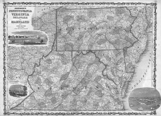
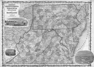
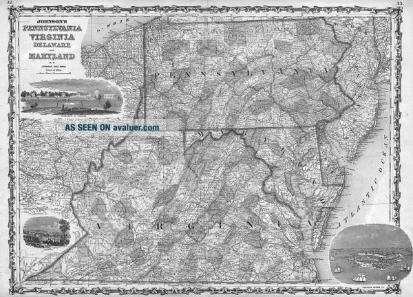
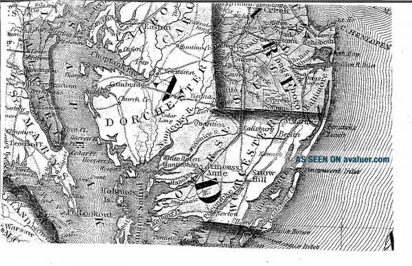
   This is a huge Black and White COPY (No Color) of an original 1862 (undated) Map of PENNSYLVANIA, VIRGINIA, DELAWARE, and MARYLAND by A.J. Johnson This map offers a fascinating snapshot of the north-south borderlands shortly following the outbreak of the American Civil War. Map shows all four states in full . This is the last edition of this Johnson map to feature an undivided Virginia. Engraved decorative views depicting the “Univ...ersity of Virginia, ” “Richmond, ” and “Fortress Monroe” decorate the upper left, lower left and lower right hand quadrants, respectively. Features the strapwork style border common to Johnson’s atlas work from 1860 to 1863. Published by A. J. Johnson and Ward as plate numbers 32 and 33 in the 1862 edition of Johnson’s New Illustrated Family Atlas . This is the first edition of the Johnson’s Atlas to bear the Johnson & Ward imprint. CHECK OUT THE ODD SHAPE OF VIRGINIA BEFORE WEST VIRGINIA SPLIT OFF THE VERY NEXT YEAR !! This map is HUGE ---- 33 inches by 24 inches!!!The city and county names in the title block do not necessarily mean they are shown on the map. I will mail out in a large mailing tube.Again, this is a Black & White COPY of the huge map, NOT THE ORIGINAL. I have the original and it is not for sale. Would make a great gift !!Thanks for looking! 

01125


    Similar items


  • 1862 Wv Map Marion Pendleton Ritchie Wyoming County West Virginia History It Big

    1862 Wv Map Marion Pendleton Ritchie Wyoming County West Virginia History It Big

  • 1862 Wv Map Brooke Roane Preston Berkeley County West Virginia History Its Huge

    1862 Wv Map Brooke Roane Preston Berkeley County West Virginia History Its Huge

  • 1862 Wv Map Ohio Mingo Mcdowell Doddridge County West Virginia History Its Huge

    1862 Wv Map Ohio Mingo Mcdowell Doddridge County West Virginia History Its Huge

  • 1862 Wv Map Monongalia Randolph Nicholas Calhoun County West Virginia History Xl

    1862 Wv Map Monongalia Randolph Nicholas Calhoun County West Virginia History Xl

  • 1862 Wv Map Wood Jackson Mercer Monroe County West Virginia Old History Its Huge

    1862 Wv Map Wood Jackson Mercer Monroe County West Virginia Old History Its Huge

  • United Confederate States 1862 Wv Map Kanawha Putnam Greenbrier County Its Huge

    United Confederate States 1862 Wv Map Kanawha Putnam Greenbrier County Its Huge

  • 1862 Wv Map Kanawha Putnam Greenbrier County Old West Virginia History Its Huge

    1862 Wv Map Kanawha Putnam Greenbrier County Old West Virginia History Its Huge

  • Us Confederate States 1862 Wv Map Lincoln Logan Marion Marshall Mason County Xl

    Us Confederate States 1862 Wv Map Lincoln Logan Marion Marshall Mason County Xl


    • You might also like


    • 1860 Mitchell Hand Colored Map Colorado,  Nebraska & Kansas - Civil War Era

      1860 Mitchell Hand Colored Map Colorado, Nebraska & Kansas - Civil War Era

    • 18th Century French Map Of North America

      18th Century French Map Of North America

    • Las Vegas Nevada Vintage 1967 Us Geological Survey Quadrangle Map 4 Panels

      Las Vegas Nevada Vintage 1967 Us Geological Survey Quadrangle Map 4 Panels

    • Rare Antique 1845 Maps United States Exploring Expedition Book Antartica Hawaii

      Rare Antique 1845 Maps United States Exploring Expedition Book Antartica Hawaii

    • Vintage 1926 Map Hollywood From The Best Surveys Of The Time

      Vintage 1926 Map Hollywood From The Best Surveys Of The Time

    • American Continent (western Hemisphere) 1747 Bowen Antique Copper Engraved Map

      American Continent (western Hemisphere) 1747 Bowen Antique Copper Engraved Map

    • Gulf Coast Florida Texas United States 1705 De Fer Unusual Antique Engraved Map

      Gulf Coast Florida Texas United States 1705 De Fer Unusual Antique Engraved Map

    • California As Island United States 1700 De Fer Unusual First Edition Antique Map

      California As Island United States 1700 De Fer Unusual First Edition Antique Map

Avaluer          About Us          Privacy Policy          Contact Us          UP
© 2022, avaluer.net, Inc. or its affiliates